Anderson County, Texas facts for kids
Quick facts for kids
Anderson County
|
|
|---|---|

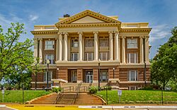
The Anderson County Courthouse in Palestine
|
|

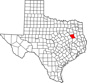
Location within the U.S. state of Texas
|
|
 Texas's location within the U.S. |
|
| Country | |
| State | |
| Founded | March 24, 1846 |
| Named for | Kenneth L. Anderson |
| Seat | Palestine |
| Largest city | Palestine |
| Area | |
| • Total | 1,078 sq mi (2,790 km2) |
| • Land | 1,063 sq mi (2,750 km2) |
| • Water | 15 sq mi (40 km2) 1.4% |
| Population
(2020)
|
|
| • Total | 57,922 |
| • Density | 54/sq mi (21/km2) |
| Time zone | UTC−6 (Central) |
| • Summer (DST) | UTC−5 (CDT) |
| Congressional district | 6th |
Anderson County is a place in Texas, a state in the United States. It's located in East Texas, and its main city, or county seat, is Palestine. In 2020, about 57,922 people lived here. Anderson County was created in 1846. It was named after Kenneth Lewis Anderson, who was the last vice president of the Republic of Texas. The county is part of the Palestine micropolitan area, which is a small city area.
Contents
History
Native American Tribes
Long ago, different Native American tribes lived in East Texas. Some of these tribes were the Kiowa, Kickapoo, Kichai, Apache, and Comanche. They hunted, farmed the land, and traded goods. By the 1770s, some tribes like the Tawakoni had settled near the Brazos and Trinity rivers. The Tawakoni were part of the Wichita Indians and made treaties with both the Republic of Texas and the United States.
In 1836, a group of tribes attacked Fort Parker. This fort was built in Anderson County in 1835 to protect settlers. Many settlers were killed or kidnapped. One famous person captured was Cynthia Ann Parker. She later became the mother of Comanche Chief Quanah Parker. Some people in Anderson County today are related to Cynthia Ann Parker.
In 1838, General Thomas Jefferson Rusk led a raid against some tribes near Frankston. This helped to end conflicts with Native Americans in East Texas for that year.
Early Settlers
In 1826, a person named David G. Burnet received permission to bring 300 families to what is now Anderson County. Most of these early settlers came from the southern states and Missouri.
A religious leader named Daniel Parker and eight other men started a church in Illinois. In 1833, their entire group moved to Texas. They were among the first settlers in the area. Fort Parker was one of the earliest settlements. After the attack on the fort, some survivors moved to Anderson County.
County Formation
Anderson County was officially formed on March 24, 1846. It was created from Houston County by the first Texas state legislature. The county was named after Kenneth Lewis Anderson. Palestine was chosen as the county seat, which is the main city where the county government is located.
During the American Civil War, Anderson County supported the Southern states that wanted to leave the Union. Judge John H. Reagan from Palestine served in the government of the Confederate States of America.
In 1875, the International – Great Northern Railroad built its repair shops and offices in Palestine. This caused the city to grow very quickly, doubling in size in just five years.
In 1928, the first successful oil well was found in Anderson County. By the year 2000, over 295 million barrels of oil had been taken from the county's land since 1929.
The Gus Engeling Wildlife Management Area was bought by the state between 1950 and 1960. It was renamed in 1952 after Gus A. Engeling, a biologist who was killed by a poacher there.
Geography
Anderson County covers about 1,078 square miles. Most of this area, 1,063 square miles, is land. The remaining 15 square miles, or about 1.4%, is water.
Major Roads
 U.S. Highway 79
 U.S. Highway 84
 U.S. Highway 175
 U.S. Highway 287
 State Highway 19
 State Highway 155
 State Highway 294
Neighboring Counties
- Henderson County (north)
- Cherokee County (east)
- Houston County (south)
- Leon County (southwest)
- Freestone County (west)
Protected Natural Areas
- Neches River National Wildlife Refuge (part)
Communities
Cities
- Palestine (county seat)
Towns
Unincorporated Areas
- Alderbranch
- Bethel
- Blackfoot
- Bois d'Arc
- Bradford
- Brushy Creek
- Cayuga
- Cronin
- Crystal Lake
- Deanwright
- Elmtown
- Elmwood
- Fosterville
- Greens Bluff
- Long Lake
- Montalba
- Mound City (partly in Houston County)
- Neches
- Pert
- Salmon
- Slocum
- Tennessee Colony
Ghost Town
Population Information
| Historical population | |||
|---|---|---|---|
| Census | Pop. | %± | |
| 1850 | 2,684 | — | |
| 1860 | 10,398 | 287.4% | |
| 1870 | 9,229 | −11.2% | |
| 1880 | 17,395 | 88.5% | |
| 1890 | 20,923 | 20.3% | |
| 1900 | 28,015 | 33.9% | |
| 1910 | 29,650 | 5.8% | |
| 1920 | 34,318 | 15.7% | |
| 1930 | 34,643 | 0.9% | |
| 1940 | 37,092 | 7.1% | |
| 1950 | 31,875 | −14.1% | |
| 1960 | 28,162 | −11.6% | |
| 1970 | 27,789 | −1.3% | |
| 1980 | 38,381 | 38.1% | |
| 1990 | 48,024 | 25.1% | |
| 2000 | 55,109 | 14.8% | |
| 2010 | 58,458 | 6.1% | |
| 2020 | 57,922 | −0.9% | |
| U.S. Decennial Census 1850–2010 2010-2020 |
|||
| Race / Ethnicity (NH = Non-Hispanic) | Pop 2000 | Pop 2010 | Pop 2020 | % 2000 | % 2010 | % 2020 |
|---|---|---|---|---|---|---|
| White alone (NH) | 34,762 | 35,792 | 33,098 | 63.08% | 61.23% | 57.14% |
| Black or African American alone (NH) | 12,897 | 12,222 | 11,430 | 23.40% | 20.91% | 19.73% |
| Native American or Alaska Native alone (NH) | 135 | 192 | 193 | 0.24% | 0.33% | 0.33% |
| Asian alone (NH) | 243 | 283 | 381 | 0.44% | 0.48% | 0.66% |
| Pacific Islander alone (NH) | 7 | 16 | 13 | 0.01% | 0.03% | 0.02% |
| Other race alone (NH) | 11 | 37 | 113 | 0.02% | 0.06% | 0.20% |
| Mixed race or Multiracial (NH) | 349 | 629 | 1,583 | 0.63% | 1.08% | 2.73% |
| Hispanic or Latino (any race) | 6,705 | 9,287 | 11,111 | 12.17% | 15.89% | 19.18% |
| Total | 55,109 | 58,458 | 57,922 | 100.00% | 100.00% | 100.00% |
Anderson County's population has changed over the years. In 1850, there were 2,684 people. By 2000, this grew to 55,109. In 2020, the population was 57,922, which was a small decrease from 2010.
The county is mostly made up of non-Hispanic white people. However, the number of Hispanic and Latino residents has grown a lot. In 2020, over 11,000 people were Hispanic or Latino. This shows how the county's population is becoming more diverse. The number of African American residents has stayed about the same. Also, the number of people who identify as mixed race has increased.
In 2020, there were about 16,555 homes in Anderson County. About 71.5% of people owned their homes. The average rent for a home was $829 per month. The average value of a home owned by its resident was $110,000.
Education
These school districts serve students in Anderson County:
- Athens Independent School District (partial)
- Cayuga Independent School District
- Elkhart Independent School District (partial)
- Frankston Independent School District (partial)
- La Poynor Independent School District (partial)
- Neches Independent School District
- Palestine Independent School District
- Slocum Independent School District
- Westwood Independent School District
Media
Anderson County is part of the Dallas/Fort Worth TV market. Local TV channels include KDFW-TV, KXAS-TV, WFAA-TV, KTVT-TV, KERA-TV, KTXA-TV, KDFI-TV, and KDAF-TV. Other TV stations from the Tyler/Longview/Jacksonville area also provide news for Anderson County. These include KLTV, KTRE-TV, KYTX-TV, KFXK-TV, and KETK-TV.
Newspapers that serve Anderson County are the Palestine Herald-Press in Palestine and the online weekly Frankston Citizen in Frankston.
See also
 In Spanish: Condado de Anderson (Texas) para niños
 | Georgia Louise Harris Brown |
 | Julian Abele |
 | Norma Merrick Sklarek |
 | William Sidney Pittman |

