Houston County, Texas facts for kids
Quick facts for kids
Houston County
|
||
|---|---|---|

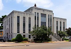
The Houston County Courthouse in Crockett is located at the intersections of Texas State Highway 21 and U.S. Highway 287.
|
||
|
||

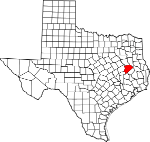
Location within the U.S. state of Texas
|
||
 Texas's location within the U.S. |
||
| Country | ||
| State | ||
| Founded | 1837 | |
| Named for | Sam Houston | |
| Seat | Crockett | |
| Largest city | Crockett | |
| Area | ||
| • Total | 1,237 sq mi (3,200 km2) | |
| • Land | 1,231 sq mi (3,190 km2) | |
| • Water | 5.7 sq mi (15 km2) 0.5% | |
| Population
(2020)
|
||
| • Total | 22,066 | |
| • Density | 17.838/sq mi (6.8874/km2) | |
| Time zone | UTC−6 (Central) | |
| • Summer (DST) | UTC−5 (CDT) | |
| Congressional district | 17th | |
Houston County is a county in the state of Texas, USA. In 2020, about 22,066 people lived there. The main town and center of the county government is Crockett.
For a long time, Houston County did not allow the sale of alcohol. But in 2007, people voted to allow it.
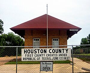
Houston County was the very first new county created when Texas was its own country, called the Republic of Texas. This happened on June 12, 1837. Back then, it was much bigger and included parts of other counties we know today.
The county is named after Sam Houston. He was a very important leader who was the President of the Republic of Texas and later the Governor of Texas. Even though they share a name, Houston County is not connected to the big city of Houston. That city is about 100 miles (160 km) south in Harris County.
Contents
History of Houston County
In the early 1900s, a large sawmill called the Four C Mill operated in Houston County. It was owned by the Central Coal and Coke Company from Missouri. They started buying huge amounts of trees in 1899.
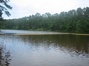
The mill began making a lot of lumber by 1902. Ratcliff Lake, which is now a fun place to visit, used to be the pond for this mill. A railroad was built to carry the lumber away. The town of Ratcliff grew up around the mill.
The mill kept working until all the trees in the area were used up. By 1920, the Four C Mill closed down.
Geography

Houston County covers about 1,237 square miles (3,204 square kilometers). Most of this area is land, with a small part being water.
Neighboring Counties
Houston County shares borders with these other counties:
- Anderson County (north)
- Cherokee County (northeast)
- Angelina County (east)
- Trinity County (southeast)
- Walker County (south)
- Madison County (southwest)
- Leon County (west)
Protected Natural Areas
Part of the Davy Crockett National Forest is located in Houston County. This is a large forest area protected by the government.
Population Information
| Historical population | |||
|---|---|---|---|
| Census | Pop. | %± | |
| 1850 | 2,721 | — | |
| 1860 | 8,058 | 196.1% | |
| 1870 | 8,147 | 1.1% | |
| 1880 | 16,702 | 105.0% | |
| 1890 | 19,360 | 15.9% | |
| 1900 | 25,452 | 31.5% | |
| 1910 | 29,564 | 16.2% | |
| 1920 | 28,601 | −3.3% | |
| 1930 | 30,017 | 5.0% | |
| 1940 | 31,137 | 3.7% | |
| 1950 | 22,825 | −26.7% | |
| 1960 | 19,276 | −15.5% | |
| 1970 | 17,855 | −7.4% | |
| 1980 | 22,299 | 24.9% | |
| 1990 | 21,375 | −4.1% | |
| 2000 | 23,185 | 8.5% | |
| 2010 | 23,732 | 2.4% | |
| 2020 | 22,066 | −7.0% | |
In 2000, there were 23,185 people living in Houston County. The population density was about 19 people per square mile. This means it's not a very crowded place.
About 28.7% of households had children under 18. The average household had 2.44 people. The median age in the county was 40 years old. This means half the people were younger than 40 and half were older.
The average income for a household in 2000 was about $28,119. About 21% of the people in the county lived below the poverty line.
Transportation
Main Roads
Several important highways pass through Houston County:
All these highways meet in downtown Crockett. State Highway 21 follows a very old path called the Old San Antonio Road, which is over 300 years old! There's also a loop road, Texas State Highway Loop 304, that goes around the city of Crockett.
Trains
The Union Pacific Railroad provides freight train service in Houston County. The old Crockett Depot, built in 1909, has been fixed up and is now the Houston County Museum.
Air Travel
The Houston County Airport (KDKR) is located about 3 miles (5 km) east of Crockett. It has a 4,000-foot (1,219 meter) runway.
Public Transport
If you need a ride, the Brazos Transit District offers public transportation services in Houston County. You can call them to arrange a ride.
Towns and Communities
Cities
- Crockett (This is the county seat, where the main government offices are)
- Grapeland
- Kennard
- Latexo
- Lovelady
Other Communities
- Ash
- Augusta
- Austonio
- Belott
- Berea
- Burrantown
- Center Hill
- Cooper
- Creath
- Fodice
- Germany
- Hagerville
- Hickory Creek
- Holly
- Hopewell
- Lone Pine
- Mapleton
- Mound City‡
- Pennington‡
- Percilla
- Porter Springs
- Ratcliff
- Refuge
- Reynard
- Stubblefield
- Tadmor
- Weches
- Weldon
Old Ghost Towns
- Allen Chapel
- Antioch
- Arbor Grove
- Center Grove
- Coltharp
- Creek
- Cut
- Druso
- Easley Chapel
- Elkins
- Givens Hill
- Guiceland
- Halls Bluff
- Liberty Hill
- Livelyville
- Mount Vernon
- Pearson's Chapel
- Plain
- Plainview
- Pleasant Grove
- Pleasant Hill
- Post Oak
- Prairie Point
- Randolph
- San Pedro
- Sand Ridge
- Shady Grove
- Shiloh
- Smith Grove
- Sorghumville
- Vistula
- Volga
- Waneta
- Wesley Chapel
- Wheeler Springs
Education
Most students in Houston County attend one of these five school districts:
- Crockett Independent School District
- Lovelady Independent School District
- Kennard Independent School District
- Latexo Independent School District
- Grapeland Independent School District
Small parts of the Groveton Independent School District and Elkhart Independent School District also reach into Houston County.
For college, students in Houston County can attend Angelina College.
See also
 In Spanish: Condado de Houston (Texas) para niños
 | Percy Lavon Julian |
 | Katherine Johnson |
 | George Washington Carver |
 | Annie Easley |


