
Cherokee County, Texas facts for kids
Quick facts for kids
Cherokee County
|
|
|---|---|

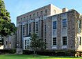
The Cherokee County Courthouse in Rusk
|
|

Location within the U.S. state of Texas
|
|
 Texas's location within the U.S. |
|
| Country | |
| State | |
| Founded | July 13, 1846 |
| Named for | Cherokee people |
| Seat | Rusk |
| Largest city | Jacksonville |
| Area | |
| • Total | 1,062 sq mi (2,750 km2) |
| • Land | 1,053 sq mi (2,730 km2) |
| • Water | 9.3 sq mi (24 km2) 0.9% |
| Population
(2020)
|
|
| • Total | 50,412 |
| • Density | 47.469/sq mi (18.328/km2) |
| Time zone | UTC−6 (Central) |
| • Summer (DST) | UTC−5 (CDT) |
| Congressional district | 6th |
Cherokee County is a county in the state of Texas. It's like a smaller region within a state, with its own local government. In 2020, about 50,412 people lived here.
The main town, called the county seat, is Rusk. Rusk is about 130 miles southeast of Dallas and 160 miles north of Houston. The county got its name from the Cherokee people, who lived in this area a long time ago.
Cherokee County is also part of the Jacksonville area, which is a group of towns that are connected.
Contents
History
Native American History

Long ago, around the year 800 AD, the Hasinai group of the Caddo tribe built a village in this area. They lived here for many centuries. Later, in the 1830s, they moved to the Brazos River area. The government eventually moved them to a reservation and then to Oklahoma.
Other Native American groups, like the Cherokee, Delaware, Shawnee, and Kickapoo, started settling here around 1820. The Texas Cherokee tried to get their own land from the Mexican government, but it didn't work out.
Sam Houston, who was friends with the Cherokee Chief Oolooteka, tried to make a peace agreement in 1836. However, the Texas government later canceled this agreement. More settlers moved onto Cherokee lands. This led to a conflict called the Cherokee War of 1839, and many Cherokee people had to move to Oklahoma. Some also went to Mexico. Later, in 1844, some Cherokee were allowed to return to Texas, and some came back to what is now Cherokee County.
Early Explorers and Settlers
In 1691, explorers from Spain like Domingo Terán de los Ríos came to this area. A French trader, Louis Juchereau de St. Denis, started trading with the Hasinai people in 1705. Spanish missions, which were like religious settlements, were set up and sometimes moved or abandoned due to conflicts.
In 1826, a person named David G. Burnet got permission from the government to bring 300 families to settle here. Most of these settlers came from the Southern states and brought their way of life with them.
How the County Grew

Cherokee County was officially created in 1846 from land that used to be part of Nacogdoches County. The town of Rusk became the main town, or county seat.
Before the American Civil War, Cherokee County voted to leave the Union.
Later, railroads helped the county grow. In 1872, the International – Great Northern Railroad caused the town of Jacksonville to move two miles east to be closer to the train tracks. More railroads were built between 1882 and 1910, and new towns popped up along these tracks.
Geography
Cherokee County covers about 1,062 square miles. Most of this area is land (1,053 square miles), and a small part (9.3 square miles) is water.
Major Roads
You can travel through Cherokee County on these main highways:
 U.S. Highway 69
 U.S. Highway 79
 U.S. Highway 84
 U.S. Highway 175
 State Highway 21
 State Highway 110
 State Highway 135
 State Highway 204
 State Highway 294
Neighboring Counties
Cherokee County shares borders with these other counties:
- Smith County (north)
- Rusk County (northeast, east)
- Nacogdoches County (east, southeast)
- Angelina County (southeast)
- Houston County (southwest)
- Anderson County (west)
- Henderson County (northwest)
Protected Areas
Part of the Neches River National Wildlife Refuge is located in Cherokee County. This is a special area set aside to protect wildlife.
Communities
Cherokee County has several cities, towns, and smaller communities.
Cities
- Gallatin
- Jacksonville
- New Summerfield
- Reklaw (partly in Rusk County)
- Rusk (county seat)
- Troup (mostly in Smith County)
Towns
- Alto
- Bullard (mostly in Smith County)
- Cuney
- Wells
Census-designated place
Unincorporated communities
- Blackjack
- Central High
- Circle
- Concord
- Cove Springs
- Craft
- Dialville
- Elm Grove
- Forest
- Gould
- Henry's Chapel
- Ironton
- Linwood
- Maydelle
- Mixon
- Mount Selman
- New Hope
- Oakland
- Pine Grove
- Ponta
- Reese
- Salem
- Shady Grove
- Sweet Union
- Weeping Mary
Ghost towns
- Atoy
- Brunswick
- Bulah
- Corine
- Earle's Chapel
- Emmaus
- Etna
- Griffin
- Java
- Larissa
- Lone Star
- Mewshaw
- Morrill
- New Birmingham
- Pierces Chapel
- Prices
- Redlawn
- Rock Hill
- Tecula
- Turney
- Wildhurst
People of Cherokee County
| Historical population | |||
|---|---|---|---|
| Census | Pop. | %± | |
| 1850 | 6,673 | — | |
| 1860 | 12,098 | 81.3% | |
| 1870 | 11,079 | −8.4% | |
| 1880 | 16,723 | 50.9% | |
| 1890 | 22,975 | 37.4% | |
| 1900 | 25,154 | 9.5% | |
| 1910 | 29,038 | 15.4% | |
| 1920 | 37,633 | 29.6% | |
| 1930 | 43,180 | 14.7% | |
| 1940 | 43,970 | 1.8% | |
| 1950 | 38,694 | −12.0% | |
| 1960 | 33,120 | −14.4% | |
| 1970 | 32,008 | −3.4% | |
| 1980 | 38,127 | 19.1% | |
| 1990 | 41,049 | 7.7% | |
| 2000 | 46,659 | 13.7% | |
| 2010 | 50,845 | 9.0% | |
| 2020 | 50,412 | −0.9% | |
| U.S. Decennial Census 1850–2010 2010 2020 |
|||
| Race / Ethnicity (NH = Non-Hispanic) | Pop 2000 | Pop 2010 | Pop 2020 | % 2000 | % 2010 | % 2020 |
|---|---|---|---|---|---|---|
| White alone (NH) | 32,347 | 31,892 | 30,095 | 69.33% | 62.72% | 59.70% |
| Black or African American alone (NH) | 7,409 | 7,401 | 6,359 | 15.88% | 14.56% | 12.61% |
| Native American or Alaska Native alone (NH) | 143 | 125 | 128 | 0.31% | 0.25% | 0.25% |
| Asian alone (NH) | 177 | 221 | 263 | 0.38% | 0.43% | 0.52% |
| Pacific Islander alone (NH) | 8 | 6 | 18 | 0.02% | 0.01% | 0.04% |
| Other Race alone (NH) | 17 | 36 | 123 | 0.04% | 0.07% | 0.24% |
| Mixed Race or Multiracial (NH) | 380 | 665 | 1,629 | 0.81% | 1.31% | 3.23% |
| Hispanic or Latino (any race) | 6,178 | 10,499 | 11,797 | 13.24% | 20.65% | 23.40% |
| Total | 46,659 | 50,845 | 50,412 | 100.00% | 100.00% | 100.00% |
In 2000, there were 46,659 people living in Cherokee County. By 2020, the population grew to 50,412. This shows that more people are choosing to live in the county.
The county is home to people from many different backgrounds. In 2020, about 59.70% of the people were non-Hispanic White, 12.61% were Black or African American, and 23.40% were Hispanic or Latino. There were also smaller groups of Native Americans, Asians, and people of two or more races. This mix of cultures makes the county a diverse place.
In 2000, about 33.40% of households had children under 18. The average household had about 2.63 people. By 2020, the average household size was similar, at 2.65 people.
The average income for a household in the county was about $29,313 in 2000. By 2020, this had grown to about $50,199.
Media
Cherokee County is part of a larger media area that includes Tyler and Longview. This means people in the county can watch TV channels like KLTV, KTRE-TV, KYTX-TV, KFXK-TV, KCEB-TV, and KETK-TV.
Local newspapers include the Jacksonville Progress, which comes out three times a week, and the weekly Cherokeean Herald in Rusk.
Education
Students in Cherokee County attend schools in several different school districts:
- Alto Independent School District
- Bullard Independent School District
- Carlisle Independent School District
- Jacksonville Independent School District
- New Summerfield Independent School District
- Rusk Independent School District
- Troup Independent School District
- Wells Independent School District
After high school, students in some areas of Cherokee County can go to Tyler Junior College. Students in other parts of the county might attend Angelina College or Kilgore College.
Images for kids
-
The Cherokee County Courthouse in Rusk
See also
 In Spanish: Condado de Cherokee (Texas) para niños
