Henderson County, Texas facts for kids
Quick facts for kids
Henderson County
|
|
|---|---|

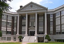
The Henderson County Courthouse in Athens
|
|

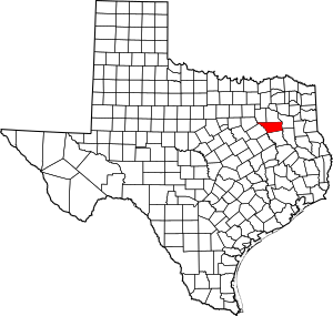
Location within the U.S. state of Texas
|
|
 Texas's location within the U.S. |
|
| Country | |
| State | |
| Founded | 1846 |
| Named for | James Pinckney Henderson |
| Seat | Athens |
| Largest city | Athens |
| Area | |
| • Total | 948 sq mi (2,460 km2) |
| • Land | 874 sq mi (2,260 km2) |
| • Water | 75 sq mi (190 km2) 7.9% |
| Population
(2020)
|
|
| • Total | 82,150 |
| • Density | 87/sq mi (34/km2) |
| Time zone | UTC−6 (Central) |
| • Summer (DST) | UTC−5 (CDT) |
| Congressional district | 5th |

Henderson County is a special area in the U.S. state of Texas. It's called a county. In 2020, about 82,150 people lived here. The main town, or county seat, is Athens.
The county got its name from James Pinckney Henderson. He was the very first attorney general for the Republic of Texas. Later, he became the first governor of Texas. Henderson County was created in 1846, just one year after Texas became a state. The first town in the county was Buffalo, started in 1847. Henderson County is also part of the larger Dallas-Fort Worth area.
Contents
Exploring Henderson County's Geography
Henderson County covers a total area of about 948 square miles. That's a lot of space! Most of it is land, but about 75 square miles are covered by water. This means there are lakes and rivers here.
Main Roads and Travel
Several important highways help people travel through Henderson County. These roads connect the county to other parts of Texas. They are:
 U.S. Highway 175
 State Highway 19
 State Highway 31
 State Highway 155
 State Highway 198
 State Highway 274
 State Highway 334
Neighboring Counties
Henderson County shares its borders with several other counties. These are like its neighbors on a map:
- Kaufman County (to the north)
- Van Zandt County (to the north)
- Smith County (to the east)
- Cherokee County (to the southeast)
- Anderson County (to the south)
- Freestone County (to the southwest)
- Navarro County (to the west)
- Ellis County (to the northwest)
Communities and Towns
Henderson County is home to many different communities. These include cities, smaller towns, and even some places that are not officially towns but still have people living there.
Cities in Henderson County
- Athens (This is the county seat, the main town)
- Brownsboro
- Chandler
- Eustace
- Gun Barrel City
- Log Cabin
- Malakoff
- Moore Station
- Murchison
- Seven Points (a small part is in Kaufman County)
- Star Harbor
- Tool
- Trinidad
Towns in Henderson County
- Berryville
- Caney City
- Coffee City
- Enchanted Oaks
- Mabank (most of it is in Kaufman County)
- Payne Springs
- Poynor
Other Communities
There is also a special area called a census-designated place:
- Sunrise Shores
Many smaller, unincorporated communities are also part of Henderson County. These places don't have their own local government like cities or towns do.
Some places that used to be communities are now called ghost towns. This means people no longer live there:
Population Changes Over Time
| Historical population | |||
|---|---|---|---|
| Census | Pop. | %± | |
| 1850 | 1,237 | — | |
| 1860 | 4,595 | 271.5% | |
| 1870 | 6,786 | 47.7% | |
| 1880 | 9,735 | 43.5% | |
| 1890 | 12,285 | 26.2% | |
| 1900 | 19,970 | 62.6% | |
| 1910 | 20,131 | 0.8% | |
| 1920 | 28,327 | 40.7% | |
| 1930 | 30,583 | 8.0% | |
| 1940 | 31,822 | 4.1% | |
| 1950 | 23,405 | −26.5% | |
| 1960 | 21,786 | −6.9% | |
| 1970 | 26,466 | 21.5% | |
| 1980 | 42,606 | 61.0% | |
| 1990 | 58,543 | 37.4% | |
| 2000 | 73,277 | 25.2% | |
| 2010 | 78,532 | 7.2% | |
| 2020 | 82,150 | 4.6% | |
| U.S. Decennial Census 1850–2010 2010–2020 |
|||
Henderson County has grown a lot over the years! In 2000, there were about 73,277 people living here. By 2020, the population had grown to 82,150. Most people in the county are white, but the number of people who are Hispanic or Latino has also grown. This shows how the county's population is becoming more diverse.
Local Media and News
Henderson County is part of a big media area that includes Dallas and Fort Worth. This means people can watch many TV channels from those cities. Some local TV stations include KDFW-TV, KXAS-TV, and WFAA-TV.
There are also TV stations from nearby cities like Tyler and Longview that cover news in Henderson County. These include KLTV and KTRE-TV.
For local news, people can read the Athens Daily Review newspaper, which is based in Athens. Another newspaper, The Monitor, is published in Mabank and also covers news in parts of Henderson County.
See also
 In Spanish: Condado de Henderson (Texas) para niños
 | William M. Jackson |
 | Juan E. Gilbert |
 | Neil deGrasse Tyson |


