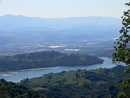
Anderson Lake (California) facts for kids
Quick facts for kids Anderson Lake |
|
|---|---|

April 2008
|
|
| Location | Santa Clara County, California |
| Coordinates | 37°10′17″N 121°37′10″W / 37.17139°N 121.61944°W |
| Type | Reservoir |
| Primary inflows | Coyote Creek |
| Primary outflows | Coyote Creek |
| Catchment area | 194.4 sq mi (503 km2) |
| Basin countries | United States |
| Managing agency | Santa Clara Valley Water District |
| Max. length | 41,184 ft (12,553 m) |
| Max. width | 3,840 ft (1,170 m) |
| Surface area | 1,271 acres (5,140,000 m2) |
| Water volume | 91,300 acre-feet (112,600,000 m3) |
| Surface elevation | 627 feet (191 m) |
Anderson Lake, also called Anderson Reservoir, is a large human-made lake in Santa Clara County, California, near Morgan Hill. It was created by building a dam across Coyote Creek.
A big county park of about 4,275-acre (1,730 ha) surrounds the lake. Here, you can enjoy fishing (but you must release the fish), picnicking, and hiking. While swimming is not allowed, you can go boating, water-skiing, and jet-skiing on the lake.
It's important to know that a health warning has been given for any fish caught in Anderson Lake. This is because of higher levels of mercury and PCBs found in the fish.
Contents
History of Anderson Lake
Anderson Lake was created in 1950. This happened when the Anderson Dam was built across Coyote Creek. The dam is located in the hills east of Morgan Hill.
The lake and dam are named after Leroy Anderson. He was a key person who helped start the Santa Clara Valley Water District. Anderson Lake is the biggest reservoir owned by this water district.
Keeping the Dam Safe
Dams need to be very strong, especially in places where earthquakes can happen. In 2009, studies showed that a very strong earthquake could cause problems for the Anderson Dam. This could lead to flooding in nearby towns like Morgan Hill and even San Jose.
Because of this, the water district decided to lower the water level in the lake. This makes the dam safer in case of a big earthquake. More studies were done, and they showed that the dam might need to be rebuilt. This would make it much stronger against earthquakes.
In 2020, a government agency called the Federal Energy Regulatory Commission ordered the water district to lower the lake's water even more. This was to make sure the dam was as safe as possible. The plan is to completely rebuild the dam to make it super safe for the future.
Flooding in San Jose
In February 2017, there were very heavy rains in California. Anderson Lake became extremely full, even overflowing its spillway. This meant a lot of water flowed into Coyote Creek.
Because of all this extra water, Coyote Creek overflowed its banks. This caused flooding in several neighborhoods in San Jose. It showed how much water the lake can hold and what can happen during very heavy rainfall.
About Anderson Dam
The Anderson Dam is an earthen dam, meaning it's made of earth and rock. It is about 235 feet (72 m) high and 1,430 feet (440 m) long. The dam is located near earthquake faults.
When the lake is full, it holds over 90,000 acre-feet (110,000,000 m3) of water. This is more water than all the other nine reservoirs in Santa Clara County combined.
Anderson Lake County Park
The Santa Clara County Parks and Recreation Department manages the 4,275-acre (1,730 ha) Anderson Lake County Park. Besides the large lake, the park has many other features.
- Coyote Creek Parkway: This is a paved trail that goes for about 15 miles (24 km) north along Coyote Creek. It's great for hiking, jogging, bicycling, horseback riding, and skating.
- Jackson Ranch: This is a historic park site.
- Moses L. Rosendin Park
- Burnett Park area
- Anderson Lake Visitors Center
 | Janet Taylor Pickett |
 | Synthia Saint James |
 | Howardena Pindell |
 | Faith Ringgold |


