
Angelino Heights, Los Angeles facts for kids
Quick facts for kids
Angelino Heights
Angeleno Heights
|
|
|---|---|

Angeleno Heights neighborhood sign
located on Beaudry Avenue south of Sunset Boulevard |
|

Angelino Heights
Location in Los Angeles
|
|
| Country | United States |
| State | California |
| County | Los Angeles County |
| City | Los Angeles |
| Elevation | 502 ft (153 m) |
Angelino Heights, sometimes spelled Angeleno Heights, is one of the oldest neighborhoods in Los Angeles. It's located between Chinatown and Echo Park. This area is famous for its many different building styles. You can see Victorian, Turn of the Century, and Revival homes here. Carroll Avenue is even listed on the National Register of Historic Places. Plus, there are over thirty Historic-Cultural Monuments in the neighborhood.
Contents
History of Angelino Heights
Angelino Heights was founded in 1886. It is the second oldest district in Los Angeles, right after Bunker Hill. At first, it was connected to downtown Los Angeles by a cable railway. Later, streetcars helped people get around.
The neighborhood is known for its steep hills. It has many beautiful examples of Victorian architecture. You can see styles like Eastlake and Queen Anne. These homes are found all over, but especially on Carroll Avenue.
Besides Victorian homes, Angelino Heights also has other cool architectural styles. These include Craftsman, Bungalow, Mission Revival, Art Deco, and Colonial Revival.
A big part of Angelino Heights was changed when the Hollywood Freeway was built. This highway cut off the neighborhood from Temple Street.
Angelino Heights was the first historic district officially recognized by Los Angeles. In 1981, the Angelino Heights Historic Preservation Overlay Zone (HPOZ) was created. This rule helps protect the old houses. It makes sure that old homes are not changed too much. It also requires new buildings to look similar to the original architecture.
Geography of Angelino Heights
Angelino Heights is bordered by the Hollywood Freeway to the south. Sunset Boulevard is to its north and east. Echo Park Lake is to the west. Sunset Boulevard is the main road through the area. Angelino Heights sits on a hill that is about 502 feet (153 meters) high.
Police Service
The Los Angeles Police Department (LAPD) helps keep the neighborhood safe. The Rampart Community Police Station serves Angelino Heights. It is located at 1401 West 6th Street.
Education
Students in Angelino Heights go to schools in the Los Angeles USD (Los Angeles Unified School District).
For elementary school, kids attend either Plasencia Elementary School or Logan Elementary. For middle school, they go to King Middle School or Virgil Middle School. All high school students in the area are zoned to Belmont High School.
Historic Places and Monuments
The 1300 block of Carroll Avenue is very special. It is listed on the National Register of Historic Places. This street has the most 19th-century Victorian homes in Los Angeles. Also, more than 30 homes in Angelino Heights are named Historic-Cultural Monuments. This means they are important and protected.
Images for kids
-
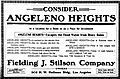
Newspaper advertisement, March 28, 1906
-
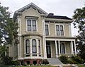
The Foy House, built in 1872, is a historic-cultural monument.
-
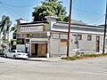
Bob's Market, built in 1910, is a historic-cultural monument.
-
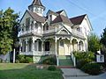
The house at 824 East Kensington Road, built in 1892, is a Los Angeles Historic-Cultural Monument.


See also
 In Spanish: Angelino Heights para niños
