
Annan River facts for kids
Quick facts for kids Annan |
|
|---|---|

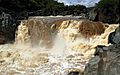
A waterfall in the Upper Annan River catchment
|
|

Location of Annan River mouth in Queensland
|
|
| Native name | Yuku Baja |
| Country | Australia |
| State | Queensland |
| Region | Far North Queensland, Wet Tropics of Queensland |
| Physical characteristics | |
| Main source | Yorkey Range below Mount Romeo 568 m (1,864 ft) 15°50′13″S 145°17′26″E / 15.83694°S 145.29056°E |
| River mouth | Walker Bay, Coral Sea south of Cooktown 0 m (0 ft) 15°31′49″S 145°16′25″E / 15.53028°S 145.27361°E |
| Length | 66 km (41 mi) |
| Basin features | |
| Basin size | 750 km2 (290 sq mi) |
| Tributaries |
|
| National parks | Black Mountain (Kalkajaka) National Park; Annan River (Yuku Baja-Muliku) National Park |
The Annan River is a river found in the Wet Tropics area of Far North Queensland, Australia. The local Kuku Nyungkal people call it Yuku Baja.
Contents
Where does the Annan River flow?
The Annan River starts in the Yorkey Range, below Mount Romeo. This is near a town called Rossville. The river flows mostly towards the northwest. Along its way, it is joined by three smaller rivers, called tributaries. These tributaries bring water from the Trevethan Range.
Eventually, the Annan River turns east towards Walker Bay. At its end, it meets the Esk River. Together, they flow into the Coral Sea, which is south of Cooktown.
How long is the Annan River?
The Annan River is about 66 kilometers (41 miles) long. It drops 568 meters (1,864 feet) from its start to its end. The river flows through two important places: the Black Mountain (Kalkajaka) National Park and the Annan River (Yuku Baja-Muliku) National Park. The area of land that collects water for the river, called its catchment area, is about 750 square kilometers (290 square miles).
What is the climate like?
The Annan River area has a wet-dry tropical climate. This means it gets most of its rain during a "wet season." About 1,800 millimeters (71 inches) of rain falls each year. Most of this rain happens between December and April. The Mulligan Highway crosses the river in two places.
How did the Annan River get its name?
The Annan River was named by an early Australian pastoralist and judge, John Jardine. On November 11, 1865, he named it after the River Annan in Scotland. He was on a ship called HMS Salamander at the time.
What is the history of the Annan River?
The Annan River, or Yuku Baja, is very important to the Kuku Nyungkal people. They are also known as the Annan River Tribe. For thousands of years, the river's waterfalls, waterholes, and waters have been a main source of life for them. It provided food and water, and many places along the river have special local names and religious meanings.
When did mining start near the river?
Towards the end of the 1800s, non-Aboriginal people began to settle in Far North Queensland. At first, they mainly mined for gold, especially at Palmer River. Later, they started mining for other metals like tin, lead, silver, and copper. This led them to move into the Annan River area, which is Kuku Nyungkal country.
In 1885, Charles Ross found tin in the upper Annan River area. This led to a small "tin rush" in 1886. For several years, people mined tin directly from underground areas and creek beds. As these easy supplies ran out, miners had to find new ways. They built water channels, called "races," through the mountains to reach tin deposits that were harder to get to.
One of these water channels was 11 kilometers (7 miles) long. It was built in 1902 by a company from Adelaide. This channel is now protected as a special heritage site in Queensland.
How have people impacted the river?
The Annan River area has been mined for tin since the late 1800s. Even today, some small tin mining operations might add sediment (dirt and small rocks) to the river. Other things that have changed the Annan River area include unsealed roads, places where cars cross the river, grazing animals, and small housing areas.
What are the heritage sites?
The Annan River Bridge is a special heritage-listed site. It is located on Development Road, near Cooktown. This bridge is a rare example of a certain type of bridge, built with plate girders and screw piles. It is also unusual because it is a low-level bridge.
What kind of plants grow around the river?
The Annan River area is considered to have "Low Development." This means that less than 30% of the land around the river has been changed by human building or farming. The area is mostly natural and covered in forests.
What types of forests are there?
The southern and eastern parts of the Annan River area have mostly rainforests and open eucalypt forests. The western and northern parts have fewer trees, with open eucalypt forests and woodlands. There are also small areas of rainforest along Oaky Creek. The flat areas near the river, called alluvial plains, are covered by tall shrubland. Near the river's mouth, there are large areas of temporary and tidal wetlands.
Images for kids
-
Annan River Falls in flood. 2004

