Anniston, Missouri facts for kids
Quick facts for kids
Anniston, Missouri
|
|
|---|---|

Anniston
|
|

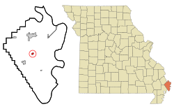
Location in Mississippi County and the state of Missouri
|
|
| Country | United States |
| State | Missouri |
| County | Mississippi |
| Area | |
| • Total | 0.39 sq mi (1.01 km2) |
| • Land | 0.39 sq mi (1.01 km2) |
| • Water | 0.00 sq mi (0.00 km2) |
| Elevation | 312 ft (95 m) |
| Population
(2020)
|
|
| • Total | 180 |
| • Density | 460.36/sq mi (177.53/km2) |
| Time zone | UTC-6 (Central (CST)) |
| • Summer (DST) | UTC-5 (CDT) |
| ZIP code |
63820
|
| Area code(s) | 573 |
| FIPS code | 29-01288 |
| GNIS feature ID | 2397433 |
Anniston is a small city in Mississippi County, Missouri, United States. In 2020, about 180 people lived there. This was fewer than the 232 people counted in 2010. In 2024, the people of Anniston voted to stop being an official city.
Contents
History of Anniston, Missouri
Anniston was first known as "Hainley's Switch." This name came from Jacob Hainley, who owned a mill in the area. A post office opened there in 1890. In 1894, the name was changed to Anniston. The new name was taken from a city called Anniston, Alabama.
Geography and Location
Anniston is located in the middle of Mississippi County. You can find it along Missouri Route 75. It is east of where Route 75 meets Missouri Route 105. The city of Charleston is about 8 miles (13 km) north. East Prairie is about 5 miles (8 km) southwest.
The U.S. Census Bureau says Anniston covers a total area of 0.39 square miles (1.01 km²). All of this area is land. The city is about 1 mile (1.6 km) west of James Bayou. It is also about 5 miles (8 km) west of the Mississippi River.
Population Changes Over Time
| Historical population | |||
|---|---|---|---|
| Census | Pop. | %± | |
| 1900 | 155 | — | |
| 1910 | 364 | 134.8% | |
| 1920 | 365 | 0.3% | |
| 1930 | 378 | 3.6% | |
| 1940 | 379 | 0.3% | |
| 1950 | 377 | −0.5% | |
| 1960 | 307 | −18.6% | |
| 1970 | 515 | 67.8% | |
| 1980 | 320 | −37.9% | |
| 1990 | 288 | −10.0% | |
| 2000 | 285 | −1.0% | |
| 2010 | 232 | −18.6% | |
| 2020 | 180 | −22.4% | |
| U.S. Decennial Census | |||
Anniston's Population in 2010
According to the census from 2010, there were 232 people living in Anniston. These people lived in 94 households. About 61 of these households were families. The city had about 595 people per square mile (230 people per km²). There were 107 homes in total.
In 2010, about 30.9% of households had children under 18 years old. About 46.8% of households were married couples. About 12.8% of homes had a female head of household with no husband. Also, 5.3% had a male head of household with no wife. About 29.8% of all households were single people. About 16% of these were people aged 65 or older living alone. The average household had 2.47 people. The average family had 3.10 people.
The average age of people in Anniston was 43.4 years. About 22.4% of residents were under 18. About 6% were between 18 and 24 years old. Around 23.7% were between 25 and 44. About 25% were between 45 and 64. Finally, 22.8% were 65 years or older. The population was 49.1% male and 50.9% female.
Education in Anniston
In 1963, voters in the Charleston, Anniston, and Fox school areas made a big decision. They voted to combine their school districts into one. The plan passed with many more votes for it than against it.
See also
 In Spanish: Anniston (Misuri) para niños
 | Sharif Bey |
 | Hale Woodruff |
 | Richmond Barthé |
 | Purvis Young |

