
Aptos Creek facts for kids
Quick facts for kids Aptos Creek |
|
|---|---|

Aptos Creek at Spreckels Boulevard bridge in April, 2017
|
|
| Other name(s) | Arroyo de Outos |
| Country | United States |
| State | California |
| Region | Santa Cruz County |
| City | Aptos |
| Physical characteristics | |
| Main source | Southwest flank of Santa Rosalia Mountain 2,502 ft (763 m) 37°04′19″N 121°51′26″W / 37.07194°N 121.85722°W |
| River mouth | Monterey Bay 7 ft (2.1 m) 36°58′11″N 121°54′22″W / 36.96972°N 121.90611°W |
| Basin features | |
| Tributaries |
|
Aptos Creek is a stream in California, United States. It flows south for about 9.5 miles (15.3 km). The creek starts on Santa Rosalia Mountain. This mountain is in the Santa Cruz Mountains. Aptos Creek ends in Monterey Bay. It meets the bay at Seacliff State Beach in Aptos, California.
Contents
History of Aptos Creek
The name "Aptos" has a long history. It comes from "Outos" or "Arroyo de Outos." This name was first recorded in 1796. It likely came from the Ohlone people. They had a village near where Aptos and Valencia Creeks meet.
Later, the area was called "Rancho de Aptos." This was a sheep ranch in 1807. In 1833, it became a large Mexican land grant. Governor José Figueroa gave it to Rafael Castro.
Aptos Creek's Path and Watershed
A watershed is an area of land. All the rain and snow that falls there drains into one stream or river. The Aptos Creek watershed covers about 24.5 square miles (63.5 square km). It starts on the southwestern side of Santa Rosalia Mountain. This mountain is about 2,585 feet (788 meters) tall.
Most of the main part of Aptos Creek's watershed is protected. It is inside The Forest of Nisene Marks State Park. This park helps keep the creek and its surroundings healthy.
Aptos Creek has several smaller streams that flow into it. These are called tributaries. The main tributaries are Bridge Creek, Mangels Gulch, and Valencia Creek. Valencia Creek also gets water from Trout Gulch.
Wildlife and Nature in Aptos Creek
The middle and upper parts of the Aptos Creek watershed are covered by a forest. This forest is made up of second-growth redwood trees. These trees were cut down between 1883 and 1923. But new trees have grown back since then.
Aptos Creek is home to important fish species. These include Coho salmon (Oncorhynchus kisutch) and steelhead trout (Oncorhynchus mykiss). These fish are very special. Coho salmon are listed as an endangered species. Steelhead trout are listed as a threatened species. This means they need protection to survive.
See Also
Images for kids
-
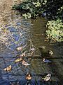
Water birds like common mergansers, coots, and mallards in Aptos Creek.
-
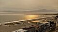
The mouth of Aptos Creek, seen from above Beach Drive.
-
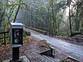
A steel bridge over Aptos Creek in The Forest of Nisene Marks State Park.


