
Arapiles, Castile and León facts for kids
Quick facts for kids
Arapiles
|
|||
|---|---|---|---|
 |
|||
|
|||

Location in Salamanca
|
|||

Arapiles, Castile and León
Location in Spain
|
|||
| Country | Spain | ||
| Autonomous community | Castile and León | ||
| Province | Salamanca | ||
| Comarca | Campo de Salamanca | ||
| Area | |||
| • Total | 25 km2 (10 sq mi) | ||
| Elevation | 840 m (2,760 ft) | ||
| Population
(2018)
|
|||
| • Total | 644 | ||
| • Density | 25.8/km2 (66.7/sq mi) | ||
| Time zone | UTC+1 (CET) | ||
| • Summer (DST) | UTC+2 (CEST) | ||
| Postal code |
37796
|
||


Arapiles is a small village and municipality located in western Spain. It is part of the Salamanca province and the Castile and León region, which is a self-governing area in Spain.
Arapiles is about 8 kilometers (5 miles) away from the city of Salamanca. Around 645 people live there. The whole area of the municipality covers about 25 square kilometers (9.6 square miles). The village sits quite high up, at 840 meters (2,756 feet) above sea level. Its postal code is 37796.
A Look at Arapiles' Past
Arapiles is famous for a very important event that happened nearby in 1812. This was a big battle during the Peninsular War. The battle is known as the Battle of Salamanca, or Batalla de los Arapiles in Spanish.
The Peninsular War was a major conflict that took place in Spain and Portugal between 1807 and 1814. It involved France, led by Napoleon Bonaparte, fighting against Spain, Portugal, and the United Kingdom. The Battle of Salamanca was a key moment in this war.
-
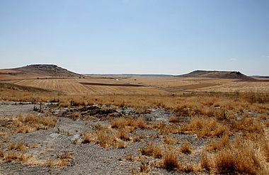
Seen from the village, the Lesser Arapile (Arapil Chico) is on the left
-
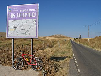
Sign showing the battlefield at Arapiles


See also
 In Spanish: Arapiles para niños
