
Archambault Lake (Saint-Donat) facts for kids
Quick facts for kids Archambault Lake |
|
|---|---|
.jpg) |
|

Archambault Lake
Location in Quebec
|
|
| Location | Saint-Donat (Municipality), MRC Matawinie, Lanaudière |
| Coordinates | 46°19′14″N 74°14′24″W / 46.320497°N 74.239941°W |
| Lake type | Natural |
| Primary inflows | (Clockwise from the mouth) Discharge of Lac Beauchamp, discharge of an unidentified lake, Saint-Michel River, discharge of lakes Ovila and Coutu, discharge of Lac du Pimbina. |
| Primary outflows | Discharge going to Lake Ouareau |
| Basin countries | Canada |
| Max. length | 12 km (7.5 mi) |
| Max. width | 0.5 km (0.31 mi) |
| Surface area | 14 km2 (5.4 sq mi) |
| Surface elevation | 390 m (1,280 ft) |
Archambault Lake is a beautiful lake found in Saint-Donat, Quebec, Canada. It's part of the Matawinie Regional County Municipality in the Lanaudière region. Water from Archambault Lake flows into Lake Ouareau to the southeast. This lake sits right on the border between the Archambault and Lussier areas.
People love to visit Archambault Lake for fun activities and vacations. This is the main way the area makes money. Another important activity is forestry, which means managing forests and cutting trees. The lake's shores are very popular for holidays because of the amazing forests, mountains, and easy road access. It's also located just south of Mont-Tremblant National Park. The village of Saint-Donat-de-Montcalm is a big vacation spot and service center. It's located on a piece of land between Archambault Lake and Lake Ouareau.
You can drive all around Archambault Lake on Régimbald Road. Route 125 goes through Saint-Donat village, and Route 329 serves the eastern side of the lake.
Archambault Lake usually freezes over from early December until the end of March. It's generally safe to walk or play on the ice from late December to early March.
Contents
Exploring Archambault Lake's Geography
Let's look at the areas around Archambault Lake and how water flows in and out.
Water Flow Around the Lake
Here are the main water areas nearby:
- To the north: Lac Provost and the Matawin River.
- To the east: Lake Ouareau and the Ouareau River.
- To the south: Lac de la Montagne Noire.
- To the west: Saint-Michel River, Le Boulé River, and Saint-Martin stream.
Shape and Features of the Lake
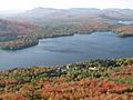
Archambault Lake has a unique zigzag shape, running mostly north to south. It gets narrower in its southern part. The northern part of the lake has two bays: Bear Bay (to the northwest) and Tire Lake (to the northeast). A long piece of land, like a finger, sticks out from the west side of the lake for about 1.7 kilometres (1.1 mi) to the east. This land creates the southern bay, which stretches for about 4.4 kilometres (2.7 mi) to the south. This southern bay is surrounded by many vacation homes and sits at the base of Mont Gaudet (which is 771 metres (2,530 ft) high) and Mont Jasper (which is 762 metres (2,500 ft) high).
How Archambault Lake Got its Name
The name of the lake might come from a pioneer who lived nearby. However, it's more likely that the name, just like the area (canton), comes from Louis Archambeault or Archambault (1814-1890). He was a notary, a representative in government, a minister, and a legislative adviser.
As early as 1880, Eugène Taché included "L. Archambault" and the area with the same name on his map of Quebec.
.
People started coming to the lake for hunting, fishing, and outdoor fun around 1915. Since then, the area has become more and more popular for tourism and recreation.
The name "lac Archambault" (Archambault Lake) probably comes from the name of a notary named Louis Archambeault or Archambault (1814-1890). He was an important person who worked in government. In 1880, a map of Quebec already showed "L. Archambault" and the surrounding area with the same name. Archambault Lake was also called Archambeault in a list of geographical names in Quebec in 1916. In the late 1800s, a lot of logging (cutting down trees) happened around the lake.
Lake Archambault in Pictures
-
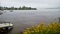
Geese rest in front of the Pioneer Park.
-
The Campus of the Four Winds, on the edge of the lake.


