
Mont-Tremblant National Park facts for kids
Quick facts for kids Mont-Tremblant National Park |
|
|---|---|
| Parc national du Mont-Tremblant | |
|
IUCN Category II (National Park)
|
|
 |
|
| Location | Les Laurentides, Matawinie and Antoine-Labelle RCMs, Quebec, Canada |
| Nearest city | Mont-Tremblant |
| Area | 1,510.10 km2 (583.05 sq mi) |
| Established | March 1, 1981 |
| Governing body | SEPAQ |
Mont-Tremblant National Park (in French, Parc national du Mont-Tremblant) is a large provincial park in Quebec, Canada. It is located north of the town of Mont-Tremblant and the villages of Saint-Donat and Saint-Côme.
This park is Quebec's oldest provincial park. It is also the second largest after Kuururjuaq National Park. The park gets its name from Mont-Tremblant, a famous mountain. Visitors can enjoy many activities all year round. These include cross-country skiing, snowshoeing, hiking, canoeing, kayaking, and mountain biking. You can also go backcountry camping and swim in clear lakes like Lake Lauzon. The park is managed by the Quebec government through an agency called the Société des établissements de plein air du Québec (SÉPAQ).
Contents
Exploring the Park: Where is Mont-Tremblant National Park?

Mont-Tremblant National Park covers a huge area of about 1,510 square kilometers (583 square miles). It is located northeast of Mont-Tremblant and stretches east towards Saint-Côme. The park is found within three regional county municipalities (MRCs): Les Laurentides, Antoine-Labelle, and Matawinie.
The park has three main areas for visitors. These are the valleys of the Diable River, the Pimbina Creek, and the Assomption River. Each area can be reached by different roads. For example, the Diable sector is easy to get to from Montreal or Ottawa.
What is the Climate Like in Mont-Tremblant?
The weather in Mont-Tremblant National Park has warm summers and cold winters. It rains or snows quite a lot throughout the year. This helps keep the forests and rivers healthy.
How Was the Park Formed? Understanding its Geology
The entire park sits on very old rocks from the Canadian Shield. These rocks are mostly gneiss and granulites. Long ago, during the Ice Age, huge glaciers moved across the land. They shaped the hills into rounded tops and carved out deep valleys.
The glaciers also left behind layers of rock and soil called till. You can find sand deposits along the rivers and lakes. This mix of rocks and soil makes the park's landscape unique.
Rivers and Lakes: The Park's Waterways

The park is home to many rivers and lakes. It is divided into three main river systems: the Rouge River (through the Diable River), the Assomption River, and the Matawin River. The shape of the lakes and streams is greatly influenced by the Canadian Shield's rocky landscape.
There are over 400 lakes in the park. The biggest one is Lake Cypress, which is about 9 square kilometers (3.5 square miles). Most of the lakes are in the northern part of the park. Because the park is at the start of several river systems, the water in its streams is very clean.
History of Mont-Tremblant National Park
The Algonquin people, who lived here long ago, called the mountain "Manitonga Soutana." This means "Mountain of Spirits" or "Mountain of the Devil." They believed the mountain made rumbling sounds and felt like it moved under their feet.
Logging, which is cutting down trees, began in this area in the 1850s. Mont-Tremblant Park was officially created on January 12, 1895. At first, the park was meant to be a place for a health center, but that plan never happened. Unlike some other parks that completely stopped logging, Quebec allowed some logging to continue here until 1981. The park started small, at 60 square kilometers (23 square miles), but it grew much larger to 1,510 square kilometers (583 square miles) by 1925.

In 1938, an American named Joe Ryan opened a ski resort on Mont-Tremblant mountain. This helped change the park's rules to allow public recreation. A research station opened at Lake Monroe in 1948. Then, in 1958, the first public camping site was created at Lake Chat. This led to more recreational areas being built in the Diable River valley and near Saint-Donat. In 1961, the park's name was changed to "Parc du Mont-Tremblant."
In 1977, Quebec changed its approach to conservation. A new law was passed that stopped commercial logging and other industrial activities in parks. Mont-Tremblant Park was given the status of a "recreation park" in 1981. This meant it was mainly for outdoor activities. In 2000, its status changed again to a "conservation park," focusing more on protecting nature. Finally, in 2001, it became "Mont-Tremblant National Park."
Wildlife and Plants: The Park's Natural Treasures
Mont-Tremblant National Park is home to a wide variety of animals and plants. It is a great place to see nature up close.
Animals: Who Lives in the Park?
The park has 40 different kinds of mammals. Some of the animals you might see are moose, deer, red fox, and black bear. You might also spot hares, red squirrels, beavers, and river otters.
There are even more types of birds, with 194 species found here. These include grouse, thrushes, nuthatches, and woodpeckers. Large birds like the great horned owl, the barred owl, and the osprey also live in the park. The park is an important resting spot for Canada geese during their migrations. The bald eagle, a majestic bird, is considered vulnerable in this area.
The park also has 7 types of reptiles and 14 types of amphibians. Many of these animals live near water. You might find bullfrogs, green frogs, newts, and different kinds of turtles like the wood turtle and the painted turtle. The wood turtle is a special concern in Quebec.
Finally, 29 types of fish swim in the park's waters. The most common are brook trout, which like cold, clear lakes, and pike, which prefer warmer waters.
The Eastern Wolf: An Important Predator
The eastern wolf is a special type of wolf that lives in the park. It is even the park's symbol! Experts believe there are about four or five wolf packs in the park, with around 35 wolves in total. These wolves mainly hunt beavers, moose, and deer. These animals make up most of their diet.
Plants: The Park's Green Landscape

The park's forests are mostly made up of sugar maple and yellow birch trees. In higher areas and in the northern part of the park, you can find fir trees mixed with yellow birch.

Other common trees include the red maple, white birch, beech, and aspen. You can also see white spruce, red spruce, and black spruce. Some special trees like hemlock, basswood, and red oak are also found here. These trees are at the northern edge of where they usually grow.
The park also protects 9 types of plants that are considered threatened or vulnerable. Most of these rare plants are found near Lake Monroe.
Activities: Fun for All Seasons
Mont-Tremblant National Park offers many ways to enjoy nature, whether it's warm or cold.
Summer and Fall Fun
- Swimming in the lakes
- Canoeing and canoe camping
- Fishing
- Hiking on many trails
- Backpacking for longer trips
- Cycling on bike paths
- Trying the Via Ferrata, a climbing route
Winter Adventures

- Snowshoeing through snowy forests
- Backcountry skiing for overnight trips
- Snow walking
- Dog sledding, pulled by a team of huskies
Images for kids
-
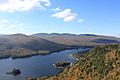
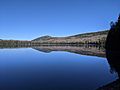
Fall view of Lac Monroe from the summit of La Corniche trail
-
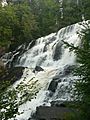
Chutes-aux-Rats
-
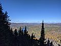
View of L'Assomption secteur
-
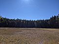
Peat bog near Lac de l'Assomption
-
Lac de l'Assomption


