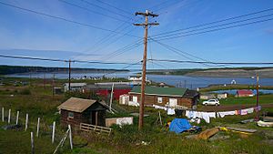
Arctic Red River facts for kids
The Arctic Red River is a long river located in the Northwest Territories, Canada. It flows into the much larger Mackenzie River. This river is very special because it was named a part of the Canadian Heritage Rivers System in 1993. This means it's recognized for its natural beauty and important history.
The river also gave its name to a nearby community. This community is now known as Tsiigehtchic. The Dempster Highway crosses the Mackenzie River right where the Arctic Red River joins it.
About the Arctic Red River
The Arctic Red River begins high up in the Mackenzie Mountains. From there, it flows for about 500 kilometres (310 miles) towards the northwest. It eventually meets the Mackenzie River.
River's Journey and Name
As the river flows, it carves its way through a deep canyon. This canyon is part of the Peel Plateau. The local Gwich'in people have a special name for the river. They call it Tsiigèhnjik, which means iron river.
The lower 200 kilometres (120 miles) of the river are easy to travel. People can explore this part using kayaks or canoes. You don't need to carry your boat over land (called portaging) in this section.
River Flow Facts
Scientists have measured the river's flow at a special station. This station is about 90 kilometres (56 miles) from where the river meets the Mackenzie. Between 1968 and 2011, the river's average flow was 158 cubic metres per second (5,580 cubic feet per second).
The highest flow ever recorded was in May 1991. It reached an amazing 3,000 cubic metres per second (106,000 cubic feet per second). The lowest flow was in December 1973, at 9.32 cubic metres per second (329 cubic feet per second).
See also
 In Spanish: Río Arctic Red para niños
 | Sharif Bey |
 | Hale Woodruff |
 | Richmond Barthé |
 | Purvis Young |


