Arctomys Peak facts for kids
Quick facts for kids Arctomys Peak |
|
|---|---|

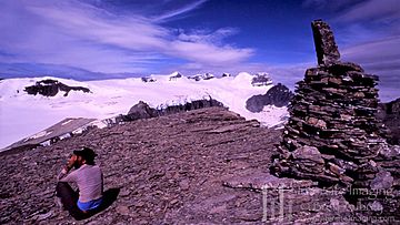
Arctomys Peak summit cairn, the Lyells in back
|
|
| Highest point | |
| Elevation | 2,793 m (9,163 ft) |
| Prominence | 184 m (604 ft) |
| Listing | Mountains of Alberta |
| Geography | |
| Country | Canada |
| Provinces | Alberta |
| Topo map | NTS 82N/10 |
| Climbing | |
| First ascent | 1918 by the Interprovincial Boundary Commission |
| Easiest route | Via Glacier Lake trail (as for the Lyells). |
Arctomys Peak is a mountain summit located in the beautiful province of Alberta, Canada. It is part of the stunning Canadian Rockies. This peak stands tall among many other impressive mountains in the region.
Contents
What is Arctomys Peak?
Arctomys Peak is a mountain that reaches a height of 2,793 meters (about 9,163 feet) above sea level. It is known for its rugged beauty and the amazing views from its top. The peak is a popular spot for adventurers and nature lovers.
How Did Arctomys Peak Get Its Name?
The name "Arctomys Peak" was given by Arthur O. Wheeler. He was a famous surveyor and mountaineer. The name "Arctomys" comes from the scientific name for a type of marmot. Marmots are furry animals that look like large squirrels. They are often found living in mountain areas. This name was chosen because these animals are native to the region around the peak.
When Was Arctomys Peak First Climbed?
The first recorded climb of Arctomys Peak happened in 1918. This ascent was made by members of the Interprovincial Boundary Commission. This group was working to map the border between provinces. Climbing the peak was part of their important work.
How Can You Reach Arctomys Peak?
The easiest way to reach Arctomys Peak is by following the Glacier Lake trail. This trail is also used to access the nearby Lyells. The journey offers incredible scenery. It is a great way to experience the Canadian Rockies.
 | James Van Der Zee |
 | Alma Thomas |
 | Ellis Wilson |
 | Margaret Taylor-Burroughs |


