Ardlethan facts for kids
Quick facts for kids ArdlethanNew South Wales |
|||||||||
|---|---|---|---|---|---|---|---|---|---|

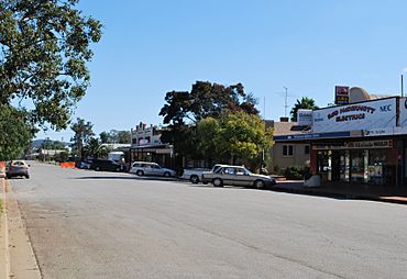
Ariah Street, the main street of Ardlethan
|
|||||||||
| Population | 387 (2016 census) | ||||||||
| Postcode(s) | 2665 | ||||||||
| Elevation | 204 m (669 ft) | ||||||||
| Location |
|
||||||||
| LGA(s) | Coolamon Shire Council | ||||||||
| County | Bourke | ||||||||
| State electorate(s) | Cootamundra | ||||||||
| Federal Division(s) | Riverina | ||||||||
|
|||||||||
Ardlethan (/ɑːrdˈliːθən/) is a small town in New South Wales, Australia. It is part of the Coolamon Shire. Ardlethan is located where two main roads meet: the Burley Griffin Way and the Newell Highway.
Many people know Ardlethan as the "Home of the Kelpie". This is because the very first Kelpie dog, a famous Australian sheepdog breed, had her first puppies here. The mother dog was born near Casterton, Victoria. That town is called the "Birthplace of the Kelpie".
Contents
History of Ardlethan
Early Days and Gold
Ardlethan was first settled in the 1800s. People came here after gold was found nearby. However, the gold mining did not last for very long.
The Railway Arrives
A railway line opened in Ardlethan in 1908. This helped the town grow by making it easier to move goods. Passenger trains stopped running in 1983. But the railway line is still used today for goods trains. The local post office, which was first called Warri, changed its name to Ardlethan in 1908.
Tin Mining in Ardlethan
Tin mining became very important for Ardlethan starting in 1912. It became a major part of the town's economy. At one point, the open-cut tin mine was the biggest in the Southern Hemisphere. It was located about 5 kilometres northwest of the town.
Mining continued underground until the late 1980s. The tin mine reopened in 2001 for a short time. It closed again in 2004 due to problems with processing and tin prices. Today, Australian Tin Resources Pty Ltd (ATR) owns the mine. They plan to start a project to clean up the site and reprocess some materials. They will first do small tests before increasing their operations.
Sports in Ardlethan
Popular Sports
Ardlethan used to have a rugby league team, which started in 1923. However, the most popular sport in Ardlethan is Australian rules football. This area is known as the 'canola belt'. It is a special area where Australian football is very popular. This is unusual because most of New South Wales supports rugby league.
In 1930, the Ardlethan Rugby Club won the Walton Shield. They won against Rankins Springs.
Ardlethan Football Club History
The Ardlethan Football Club started in 1912. They first played in the Barellan & District Football Association. The club stopped playing between 1916 and 1918 because of World War One.
The club started again in 1919. They played in different leagues over the years. In 1952, Ardlethan FC won the Barellan Football Association premiership. They beat Kamarah while wearing black and white uniforms.
From 1956 to 1981, the club played in the South West Football League (New South Wales). Their uniform had three vertical stripes: red, black, and gold. Later, they joined the Riverina Football League in 1982. Then they moved to the Farrer Football League in 1987.
In 2004, the Ardlethan Football Club joined with Ariah Park - Mirrool. They formed a new team called the Northern Jets Football Club. This team still plays in the Farrer Football League today.
Population
In 2024, Ardlethan has a population of 387 people.
Climate
| Climate data for Ardlethan Post Office | |||||||||||||
|---|---|---|---|---|---|---|---|---|---|---|---|---|---|
| Month | Jan | Feb | Mar | Apr | May | Jun | Jul | Aug | Sep | Oct | Nov | Dec | Year |
| Record high °C (°F) | 44.4 (111.9) |
44.4 (111.9) |
39.4 (102.9) |
32.2 (90.0) |
27.0 (80.6) |
23.8 (74.8) |
25.9 (78.6) |
25.6 (78.1) |
33.9 (93.0) |
35.0 (95.0) |
39.0 (102.2) |
42.7 (108.9) |
44.4 (111.9) |
| Mean daily maximum °C (°F) | 32.3 (90.1) |
31.1 (88.0) |
28.7 (83.7) |
23.3 (73.9) |
18.0 (64.4) |
14.7 (58.5) |
14.1 (57.4) |
15.6 (60.1) |
19.2 (66.6) |
22.7 (72.9) |
25.9 (78.6) |
30.5 (86.9) |
23.0 (73.4) |
| Mean daily minimum °C (°F) | 16.3 (61.3) |
16.4 (61.5) |
13.5 (56.3) |
9.4 (48.9) |
6.1 (43.0) |
3.3 (37.9) |
2.7 (36.9) |
3.6 (38.5) |
5.8 (42.4) |
8.8 (47.8) |
10.6 (51.1) |
13.9 (57.0) |
9.2 (48.6) |
| Record low °C (°F) | 6.0 (42.8) |
6.7 (44.1) |
3.3 (37.9) |
−0.6 (30.9) |
−3.3 (26.1) |
−4.4 (24.1) |
−6.1 (21.0) |
−3.9 (25.0) |
−3.3 (26.1) |
−1.7 (28.9) |
2.2 (36.0) |
5.0 (41.0) |
−6.1 (21.0) |
| Average precipitation mm (inches) | 42.4 (1.67) |
38.7 (1.52) |
36.8 (1.45) |
35.9 (1.41) |
40.4 (1.59) |
42.1 (1.66) |
42.8 (1.69) |
42.6 (1.68) |
38.8 (1.53) |
44.7 (1.76) |
39.3 (1.55) |
37.3 (1.47) |
481.8 (18.97) |
| Average rainy days | 4.3 | 3.9 | 3.9 | 4.5 | 6.2 | 7.9 | 8.8 | 8.4 | 7.0 | 6.7 | 5.1 | 4.5 | 71.2 |
Notable people
- Rod Coelli, an Australian rules footballer
 | Mary Eliza Mahoney |
 | Susie King Taylor |
 | Ida Gray |
 | Eliza Ann Grier |


