Arkoma, Oklahoma facts for kids
Quick facts for kids
Arkoma, Oklahoma
|
|
|---|---|

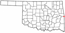
Location of Arkoma, Oklahoma
|
|
| Country | United States |
| State | Oklahoma |
| County | LeFlore |
| Area | |
| • Total | 3.52 sq mi (9.11 km2) |
| • Land | 3.47 sq mi (9.00 km2) |
| • Water | 0.04 sq mi (0.12 km2) |
| Elevation | 423 ft (129 m) |
| Population
(2020)
|
|
| • Total | 1,806 |
| • Density | 519.86/sq mi (200.75/km2) |
| Time zone | UTC-6 (Central (CST)) |
| • Summer (DST) | UTC-5 (CDT) |
| ZIP code |
74901
|
| Area codes | 539/918 |
| FIPS code | 40-02650 |
| GNIS feature ID | 2411644 |
Arkoma is a small town in Oklahoma, located in LeFlore County. It is part of the larger Fort Smith, Arkansas-Oklahoma area. In 2020, about 1,806 people lived there.
The town's name, Arkoma, is a mix of two state names: Arkansas and Oklahoma. For a long time, Arkoma has been known as a "bedroom community". This means many people who live in Arkoma travel to nearby Fort Smith, Arkansas for work.
History of Arkoma
The community of Arkoma started around 1911. It was built on land owned by Captain James Reynolds. He was a veteran of the American Civil War who had married into the Choctaw Nation.
Captain Reynolds wanted to create a new neighborhood near Fort Smith. He built houses to rent out to people. He also convinced a company called Fort Smith Light and Traction to build electric trolley tracks. These trolleys carried people to and from his new community. However, the trolley service stopped in 1917.
Arkoma officially became an incorporated town in 1946. This means it gained its own local government.
Geography and Climate
Arkoma is located on the same side of the Arkansas River as Fort Smith, Arkansas. It is bordered by the Poteau River to the west and north. The state line between Arkansas and Oklahoma is to its east.
The town covers about 3.6 square miles (9.3 square kilometers). Most of this area is land, with a small part being water.
Arkoma has a mild climate. Winters are often not too cold, and summers are usually hot.
Population and People
| Historical population | |||
|---|---|---|---|
| Census | Pop. | %± | |
| 1950 | 1,691 | — | |
| 1960 | 1,862 | 10.1% | |
| 1970 | 2,098 | 12.7% | |
| 1980 | 2,175 | 3.7% | |
| 1990 | 2,393 | 10.0% | |
| 2000 | 2,180 | −8.9% | |
| 2010 | 1,989 | −8.8% | |
| 2020 | 1,806 | −9.2% | |
| U.S. Decennial Census | |||
In 2010, there were 1,989 people living in Arkoma. The population has changed over the years, as you can see in the chart above.
Most people living in Arkoma are White. There are also Native American, African American, and Asian residents. Some people are from two or more races. A small number of residents are Hispanic or Latino.
There were 877 households in the town. About 28% of these households had children under 18 living with them. Many households were married couples living together.
The average age of people in Arkoma was about 38 years old. About a quarter of the population was under 18.
The average income for families in Arkoma was around $31,500 per year. Some families and individuals live below the poverty line.
See also
 In Spanish: Arkoma (Oklahoma) para niños
 | Stephanie Wilson |
 | Charles Bolden |
 | Ronald McNair |
 | Frederick D. Gregory |


