Arratzua-Ubarrundia facts for kids
Quick facts for kids
Arratzua-Ubarrundia
|
||
|---|---|---|

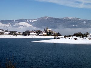
View of Ullíbarri-Gamboa
|
||
|
||
| Country | Spain | |
| Autonomous community | Basque Country | |
| Province | Álava | |
| Comarca | Gorbeialdea | |
| Area | ||
| • Total | 57.41 km2 (22.17 sq mi) | |
| Elevation | 541 m (1,775 ft) | |
| Population
(2018)
|
||
| • Total | 982 | |
| • Density | 17.105/km2 (44.302/sq mi) | |
| Time zone | UTC+1 (CET) | |
| • Summer (DST) | UTC+2 (CEST) | |
| Postal code |
01510, 01520
|
|
| Official language(s) | Basque Spanish |
|
Arratzua-Ubarrundia is a small area in northern Spain. It's called a municipality, which is like a local government area. This place is found in the Álava province, within the Basque Country. The main village and capital of Arratzua-Ubarrundia is Durana.
Contents
Exploring Arratzua-Ubarrundia
Where is Arratzua-Ubarrundia?
This municipality is located in the northern part of Spain. It's part of the Basque Country, a region known for its unique culture and language. The area is about 57 square kilometers, which is roughly the size of 5,700 football fields.
How is Arratzua-Ubarrundia Organized?
Arratzua-Ubarrundia is made up of 11 different villages. Ten of these villages are organized as concejos. A concejo is a small local council or community. It helps manage local affairs for its village.
The main village and capital is Durana. It's the largest village in the municipality. Other important villages include Zurbano/Zurbao and Arroiabe. Each village has its own special character.
What Languages are Spoken?
In Arratzua-Ubarrundia, people speak two official languages. These are Basque and Spanish. Basque is a very old language unique to the Basque Country.
Who Leads Arratzua-Ubarrundia?
The leader of the municipality is called the Mayor. The current Mayor is Blanca Antépara Uribe. She is part of the EAJ/PNV. The Mayor and the local council work together to make decisions for the community. They help manage things like local services and public spaces.
See also
 In Spanish: Arrazua-Ubarrundia para niños
 | May Edward Chinn |
 | Rebecca Cole |
 | Alexa Canady |
 | Dorothy Lavinia Brown |


