
Arrecife facts for kids
Quick facts for kids
Arrecife
|
|||
|---|---|---|---|
|
City
|
|||

Aerial view of Arrecife
|
|||
|
|||
_-_OSM_Mapnik.svg)
Arrecife
Location in Lanzarote

Arrecife
Location in Canary Islands

Arrecife
Location in Spain, Canary Islands
|
|||
| Country | Spain | ||
| Autonomous Community | |||
| Province | Las Palmas | ||
| Island | Lanzarote | ||
| Area | |||
| • Total | 22.72 km2 (8.77 sq mi) | ||
| Elevation
(AMSL)
|
20 m (70 ft) | ||
| Population
(2018)
|
|||
| • Total | 61,351 | ||
| • Density | 2,700.3/km2 (6,993.8/sq mi) | ||
| Time zone | UTC+00:00 (WET) | ||
| • Summer (DST) | UTC+01:00 (WEST) | ||
| Postal code |
35500
|
||
| Area code(s) | +34 (Spain) + 928 (Las Palmas) | ||
| Website | www.arrecife.es | ||


Arrecife is the capital city and a municipality of Lanzarote in the Canary Islands. It became the island's capital in 1852. The city gets its name from the Spanish word "arrecife," which means "reef." This is because of the natural rock reefs that protect its local beach. Arrecife Airport, the island's airport, is also named after the city. In 2020, about 64,645 people lived in Arrecife. The city covers an area of about 22.72 square kilometers (8.77 sq mi).
Arrecife is located south of Teguise and east of San Bartolomé. The Atlantic Ocean borders it to the southeast. It is an important port town. Ferries connect Arrecife to other Canary Islands, Europe, and Africa. Major roads like the LZ1, LZ2, and LZ3 connect the city to different parts of Lanzarote. The tallest building on the island, the Arrecife Gran Hotel, stands proudly by the harbor.
Contents
History of Arrecife
The first records of Arrecife are from the 1400s. Back then, it was a small fishing village. The name Arrecifes was used because boats could hide behind the black volcanic reefs. These reefs protected them from sudden pirate attacks.
By the late 1500s, the village started to grow. More buildings were needed for people and for storing goods. This was because trade between the old and new worlds was increasing. The first church was built around this time. It was named after the first bishop of Arrecife, San Ginés. As the town became richer, it also became a bigger target for pirates. In 1571, a pirate named Dogan attacked and almost completely destroyed the small port town.
In 1964, Arrecife became home to Lanzarote's first sea-water desalination plant. This plant turns salty ocean water into fresh drinking water.
Climate in Arrecife
Lanzarote has a hot desert climate. This means it is usually very warm and dry. Most of the small amount of rain it gets falls during the winter months.
| Climate data for Lanzarote Airport (1981-2010) | |||||||||||||
|---|---|---|---|---|---|---|---|---|---|---|---|---|---|
| Month | Jan | Feb | Mar | Apr | May | Jun | Jul | Aug | Sep | Oct | Nov | Dec | Year |
| Record high °C (°F) | 27.9 (82.2) |
29.0 (84.2) |
32.7 (90.9) |
36.3 (97.3) |
42.6 (108.7) |
40.7 (105.3) |
42.9 (109.2) |
43.6 (110.5) |
40.5 (104.9) |
37.1 (98.8) |
34.2 (93.6) |
27.5 (81.5) |
43.6 (110.5) |
| Mean daily maximum °C (°F) | 20.7 (69.3) |
21.3 (70.3) |
22.9 (73.2) |
23.5 (74.3) |
24.6 (76.3) |
26.3 (79.3) |
28.2 (82.8) |
29.1 (84.4) |
28.6 (83.5) |
26.7 (80.1) |
24.2 (75.6) |
21.8 (71.2) |
24.8 (76.6) |
| Daily mean °C (°F) | 17.4 (63.3) |
17.9 (64.2) |
19.0 (66.2) |
19.6 (67.3) |
20.8 (69.4) |
22.6 (72.7) |
24.3 (75.7) |
25.2 (77.4) |
24.7 (76.5) |
23.0 (73.4) |
20.7 (69.3) |
18.6 (65.5) |
21.1 (70.0) |
| Mean daily minimum °C (°F) | 14.0 (57.2) |
14.3 (57.7) |
15.0 (59.0) |
15.7 (60.3) |
16.8 (62.2) |
18.8 (65.8) |
20.4 (68.7) |
21.2 (70.2) |
20.8 (69.4) |
19.4 (66.9) |
17.2 (63.0) |
15.4 (59.7) |
17.4 (63.3) |
| Record low °C (°F) | 8.0 (46.4) |
9.0 (48.2) |
8.3 (46.9) |
9.5 (49.1) |
11.5 (52.7) |
12.4 (54.3) |
15.4 (59.7) |
16.6 (61.9) |
15.5 (59.9) |
12.0 (53.6) |
10.9 (51.6) |
9.0 (48.2) |
8.0 (46.4) |
| Average rainfall mm (inches) | 16.5 (0.65) |
18.2 (0.72) |
12.5 (0.49) |
5.2 (0.20) |
1.5 (0.06) |
0.1 (0.00) |
0.0 (0.0) |
0.5 (0.02) |
2.2 (0.09) |
9.9 (0.39) |
14.7 (0.58) |
29.3 (1.15) |
110.6 (4.35) |
| Average rainy days (≥ 1.0 mm) | 3 | 3 | 2 | 1 | 0 | 0 | 0 | 0 | 0 | 2 | 3 | 4 | 18 |
| Mean monthly sunshine hours | 203 | 201 | 241 | 255 | 297 | 292 | 308 | 295 | 248 | 235 | 207 | 196 | 2,978 |
| Source: Agencia Estatal de Meteorología | |||||||||||||
Population Growth
The number of people living in Arrecife has grown quite a bit over the years. Here's how the population has changed:
| Historical population | ||||||||||||||||||||||||||||
|---|---|---|---|---|---|---|---|---|---|---|---|---|---|---|---|---|---|---|---|---|---|---|---|---|---|---|---|---|
|
|
|||||||||||||||||||||||||||
| Source: Centro de Datos, Cabildo de Lanzarote | ||||||||||||||||||||||||||||
Arrecife's Economy
The Port of Arrecife is very important for Lanzarote. It is the second busiest port in the Canary Islands for passengers. Many different types of ships use this port:
- Passenger ferries that travel to other islands or countries.
- Large cruise ships bringing tourists.
- Cargo ships that carry goods like containers, bulk materials, and liquids.
- It also has a large port for fishing boats.
Local Areas
Arrecife includes different areas, such as:
- Urbanización Playa Honda (a neighborhood)
Cultural Landmarks
Arrecife has several important buildings and places that are protected for their cultural value. These include:
- Casa de los Arroyo
- Castillo de San Gabriel (San Gabriel Castle)
- Castillo de San José (San José Castle)
- Iglesia Matriz de San Ginés Obispo (Main Church of San Ginés Obispo)
- Fachada del edificio Segarra (Segarra building facade)
- Headquarters of the Island Council of Lanzarote
- Salinas de Naos (Naos Salt Pans)
- Salinas de Bufona (Bufona Salt Pans)
Places to Visit
If you visit Arrecife, here are some interesting places you might want to see:
- Playa Reducto: This is Arrecife's main town beach, perfect for relaxing.
- Castillo de San José: An 18th-century fortress that now holds a collection of modern art.
- Puente de Las Bolas: A bridge that leads to the Castillo de San Gabriel.
- Charco de San Ginés: A calm, man-made lagoon that local fishermen use.
Gallery
-

Church of San Ginés
-
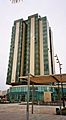
The Gran Hotel Arrecife
-
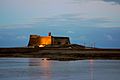
Castle of San Gabriel


See also
 In Spanish: Arrecife (España) para niños
