
Arsia Mons facts for kids

This image combines data from the Viking mission and the MOLA. It shows the volcano's shape, with its sides appearing taller than they are to highlight features.
|
|
| Feature type | Shield volcano |
|---|---|
| Coordinates | 8°21′S 120°05′W / 8.35°S 120.09°W |
| Peak | 11.7 km (7.3 mi) 38,386 ft (11,700 m) |
| Eponym | Named after Arsia Silva, a legendary Roman forest. This name was first used for a dark area (an albedo feature) on Mars by Giovanni Schiaparelli. |
Arsia Mons is a huge volcano on the planet Mars. It is the southernmost of three large volcanoes, known together as the Tharsis Montes. These volcanoes are located on a raised area called the Tharsis bulge, near Mars' equator. To its north are Pavonis Mons and Ascraeus Mons. The tallest volcano in our Solar System, Olympus Mons, is also nearby, to its northwest. Arsia Mons gets its name from a dark feature on early maps of Mars, which was named after the legendary Roman forest, Silva Arsia. Long ago, it was also called Nodus Gordii, meaning "Gordian knot."
Contents
A Giant Martian Volcano
Arsia Mons is a type of volcano called a shield volcano. This means it has gentle slopes, much like a warrior's shield lying on the ground. At its very top, it has a massive caldera, which is a large bowl-shaped crater.
Its Shape and Size
This giant volcano is about 435 kilometers (270 miles) wide. It stands almost 20 kilometers (12 miles) high, which is more than 9 kilometers (5.6 miles) taller than the plains around it. The caldera at its summit is 110 kilometers (72 miles) across. At the very top of Arsia Mons, the air pressure is extremely low.
Arsia Mons is one of the largest volcanoes by volume in the Solar System, second only to Olympus Mons. It holds about 30 times more material than Mauna Loa in Hawaii, which is Earth's largest volcano.
How the Caldera Formed
The huge caldera at the top of Arsia Mons formed when the volcano's underground magma chamber emptied out. Magma is molten rock found beneath a planet's surface. Once the magma was gone, the ground above it collapsed, creating the large crater we see today. The floor of this caldera formed about 150 million years ago. There are also many other collapsed areas on the sides of the mountain.
Cracks and Lava Flows
A series of cracks and collapsed areas run across the volcano from northeast to southwest. These features are connected by a line of smaller shield volcanoes inside the caldera. Scientists think this line might be a major crack, or fault, similar to others found on the Tharsis bulge. This fault could have been the source of the lava that built Arsia Mons.
The European Space Agency's Mars Express probe took detailed pictures of the rift area to the southwest. In 2004, scientists made a 3D map of this area. You can see cliffs, landslides, and many collapsed areas in this detailed image. These features, along with large lava flows, might show where lava drained from the caldera, causing it to collapse.
The northwest side of the volcano looks much rougher than the southeast side. These rough features might be signs of ancient glaciers.
Mars' Moving Surface?

The three Tharsis Montes volcanoes, along with some smaller ones to the north, line up in a fairly straight row. Some scientists have suggested that this alignment could be a result of plate tectonics. On Earth, plate tectonics involves large pieces of the planet's crust slowly moving. This movement can create chains of volcanoes over "hot spots" in the mantle, like the Hawaiian Islands.
A Look Back in Time: Arsia Mons' Eruptions
The most recent period of eruptions on Arsia Mons is considered among the youngest on Mars. This activity involved at least 29 openings within the caldera and also eruptions on the volcano's slopes. Scientists believe these eruptions happened between 200 and 300 million years ago, and then again between 10 and 90 million years ago. The peak of this activity was around 150 million years ago.
Martian Weather Wonders
Each year, as southern winter begins on Mars, a special weather event happens over Arsia Mons. Sunlight warms the air on the volcano's slopes. On the side sheltered from the wind, water ice in the air turns into a cloud. This cloud can stretch for more than 1,000 kilometers (620 miles) to the west. In the autumn of 2018, this type of cloud, called an orographic cloud, was especially noticeable after a planet-wide dust storm had settled. The dust likely made the cloud even more visible. The Mars Express orbiter has observed this cloud phenomenon many times.
Scientists have also studied how ancient volcanic ash might have shaped Mars. A climate model suggests that the Medusae Fossae Formation could have been created from ash blown from volcanoes like Apollinaris Mons, Arsia Mons, and possibly Pavonis Mons.
Evidence of Ancient Ice
Scientists have found evidence suggesting that glaciers once existed on Arsia Mons, both at high and low elevations. Some parallel ridges look like moraines, which are piles of rocks and dirt left behind by moving glaciers. Another area appears to have formed when ice melted underground, creating a bumpy landscape. The lower parts of the volcano show lobed features that seem to have flowed downhill. These lobed areas might still contain a core of ice, covered by a thin layer of rocks that protects the ice from sublimating (turning directly from ice into gas).
Mysterious Pits and Possible Caves

Since 2007, scientists have found seven possible cave entrances on the sides of Arsia Mons using satellite images. These openings have been informally named Dena, Chloë, Wendy, Annie, Abbey, Nikki, and Jeanne. They look like "skylights," which are holes formed when the ceiling of an underground lava tube collapses. Lava tubes are tunnels created by flowing lava.
Here are their locations:
- Dena (6°05′02″S 239°03′40″E / 6.084°S 239.061°E)
- Chloë (4°17′46″S 239°11′35″E / 4.296°S 239.193°E)
- Wendy (8°05′56″S 240°14′31″E / 8.099°S 240.242°E)
- Annie (6°16′01″S 240°00′18″E / 6.267°S 240.005°E)
- Abbey and Nikki (8°29′53″S 240°20′56″E / 8.498°S 240.349°E)
- Jeanne (5°38′10″S 241°15′32″E / 5.636°S 241.259°E)
The temperature inside these circular features changes much less from day to night compared to the surrounding ground. This suggests they are deep pits. A more recent photo of one of these features shows sunlight hitting a side wall. This means it might just be a deep vertical pit, rather than an entrance to a large underground cave system. However, how dark it appears suggests it must be at least 178 meters (584 feet) deep.
Images for kids
-
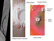
Arsia Mons, as seen by THEMIS. Click on image to see relationship of Arsia Mons to other nearby volcanoes.
-
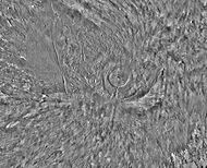
Arsia Mons and its surroundings in a THEMIS daytime infrared image mosaic. A huge fan-shaped expanse of knobby deposits (the Arsia Sulci), believed left by past glaciation, extends northwestward from the mountain.
-
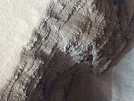
Layers from numerous lava flows are exposed on the side of a pit on the lower west flank of Arsia Mons (photo by HiRISE).
-
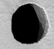
Possible cave entrance ("Jeanne") on Arsia Mons


See also
- Caves of Mars Project
- List of mountains on Mars by height
- List of tallest mountains in the Solar System
- Tharsis quadrangle
