
Olympus Mons facts for kids

Viking 1 orbiter view of Olympus Mons with its summit caldera, escarpment, and aureole
|
|
| Coordinates | 18°39′N 226°12′E / 18.650°N 226.200°E |
|---|---|
| Peak | 21.9 km (13.6 mi) above datum 26 km (16 mi) local relief above plains |
| Discoverer | Mariner 9 |
| Eponym | Latin – Mount Olympus |
Olympus Mons is a giant shield volcano on the planet Mars. It is the tallest volcano, and the tallest mountain, in our entire solar system.
Contents
How Big is Olympus Mons?
Olympus Mons is about 27 km (17 mi) high. This makes it three times taller than Mount Everest, the highest mountain on Earth.
The volcano is shaped like the large volcanoes found in the Hawaiian Islands. It is about 600 km (370 mi) wide. This is roughly the size of a country like France or Poland!
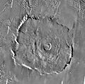
Because Olympus Mons is so huge, it's hard to say its exact height. It stands 21 km (13 mi) above the average surface level of Mars. From the plains around its base to its peak, it rises over 21 km (13 mi). The very top of the mountain has six large, collapsed craters called calderas. These form a big, uneven dip about 60 km (37 mi) by 80 km (50 mi) wide and up to 3.2 km (2.0 mi) deep.
The outer edge of the volcano has a steep cliff, or escarpment, up to 8 km (5.0 mi) tall. This cliff is special among Mars's shield volcanoes. It might have been made by huge landslides on the volcano's sides. Olympus Mons covers an area of about 300,000 km2 (120,000 sq mi). This is about the size of Italy or the Philippines.
What Does Olympus Mons Look Like?


Olympus Mons is a shield volcano, which means it has very gentle slopes. The average slope on its sides is only 5%. This is not very steep at all! The slopes are steepest near the middle and get flatter towards the base.
Because the volcano is so big and its slopes are so gentle, you wouldn't be able to see the whole volcano if you stood on the Martian surface. The curve of the planet and the volcano itself would block your view. If you were standing near the top, you wouldn't even realize you were on a huge mountain. The slope would just stretch out far beyond the horizon.
The air pressure at the top of Olympus Mons is very low. It's only about 12% of the average air pressure on Mars. Both are much lower than on Earth. For example, the air pressure at the top of Mount Everest is about 32% of Earth's sea level pressure. Even with low pressure, high-altitude clouds often float over the summit. There is also still dust in the air.
The rocks that make up Olympus Mons are mostly basalt. This is a type of rock that forms from runny lava flows. This is why the volcano has such gentle slopes.
How Olympus Mons Formed
Olympus Mons formed from thousands of very fluid, basaltic lava flows. These flows came out of volcanic vents over a very long time. The Hawaiian Islands on Earth are similar, but much smaller, shield volcanoes.
Because Mars has less gravity than Earth, magma (melted rock) rises more easily from inside the planet. Scientists think the magma chambers under Mars's volcanoes are much larger and deeper than Earth's. This allowed Olympus Mons to grow to an enormous size.
The sides of Olympus Mons are covered in countless lava flows and channels. Many of these flows have natural walls called levees along their edges. These form when the cooler outer parts of a lava flow harden, leaving a channel of molten lava in the middle.
Sometimes, lava tubes (underground tunnels made by flowing lava) partly collapse. This creates chains of pit craters on the surface. Large fans of lava also formed where lava came out of intact underground tubes.
Scientists have studied images from the Mars Express orbiter. They found that some lava flows on the northwestern side of Olympus Mons are as young as 2 million years old. This is very recent in terms of geology. It suggests that the mountain might still be active, but erupts very quietly and rarely.
The group of collapsed craters at the peak of the volcano has at least six overlapping calderas. These calderas formed when the roof of the underground magma chamber collapsed after an eruption. Each caldera shows a different period of volcanic activity. The largest and oldest caldera seems to have formed from a single, large lava lake.
Scientists believe the magma chamber for the largest caldera is about 32 km (105,000 ft) deep. The calderas range in age from 350 million years old to about 150 million years old. They probably all formed within 100 million years of each other.
Olympus Mons is located on the edge of the Tharsis bulge. This is a very old and huge volcanic plateau on Mars. As Olympus Mons grew, it spread out at its base. This spreading, especially into softer ground, helped create the large cliff at its base.
Discovery of Olympus Mons

Olympus Mons and other volcanoes in the Tharsis region are so tall that they rise above the frequent Martian dust storms. Astronomers in the 19th century observed these dust storms with telescopes. Giovanni Schiaparelli noticed that "Nix Olympica" (Latin for "Olympic Snow") was one of the only features he could see during dust storms. He correctly guessed that it must be very high.
The Mariner 9 spacecraft arrived at Mars in 1971 during a global dust storm. As the dust settled, the tops of the Tharsis volcanoes were the first things to become visible. This showed that these features were much taller than any mountain on Earth. Observations from Mariner 9 confirmed that Nix Olympica was indeed a volcano. Later, astronomers officially named it Olympus Mons.
See also
 In Spanish: Olympus Mons para niños
- Areography (geography of Mars)
- Geology of Mars
- List of mountains on Mars by height
- List of tallest mountains in the Solar System
- Volcanism on Mars
Images for kids
-
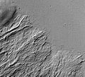
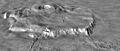
Olympus Rupes, the northern part of Olympus Mons.
-
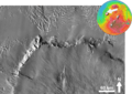
Mars Global Surveyor image showing lava flows of different ages at the base of Olympus Mons. The flat plain is the younger flow. The older flow has lava channels with levees along the edges. Levees are quite common to lava flows on Mars.
-
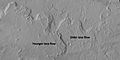
Lava flows on Olympus Mons with older and younger flows labeled, as viewed by HiRISE during the HiWish program.
-
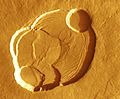
Calderas on the summit of Olympus Mons. The youngest calderas form circular collapse craters. Older calderas appear as semicircular segments because they are transected by the younger calderas.
-
Oblique view of Olympus Mons, from a Viking image mosaic overlain on MOLA altimetry data, showing the volcano's asymmetry. The view is from the NNE; vertical exaggeration is 10×. The wider, gently sloping northern flank is to the right. The more narrow and steeply sloping southern flank (left) has low, rounded terraces, features interpreted as thrust faults. The volcano's basal escarpment is prominent.
-
Detailed THEMIS daytime infrared image mosaic of Olympus Mons.


