Ashfield, Stirling facts for kids
Quick facts for kids Ashfield
|
|
|---|---|
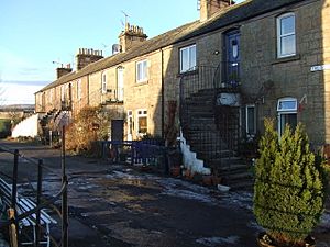
 The Square, Ashfield |
|
| Population | 139 |
| OS grid reference | NN784037 |
| Civil parish |
|
| Council area | |
| Lieutenancy area |
|
| Country | Scotland |
| Sovereign state | United Kingdom |
| Post town | Dunblane |
| Postcode district | FK15 |
| Dialling code | 01786 |
| Police | Central Scotland |
| Fire | Central Scotland |
| Ambulance | Scottish |
| EU Parliament | Scotland |
| UK Parliament |
|
| Scottish Parliament | |
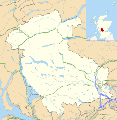
Ashfield (which is Achadh an Uinnsinn in Scottish Gaelic) is a small village in Scotland. It's located in the Stirling area. The village sits between the Allan Water river and the railway line that connects Stirling and Perth.
Ashfield is about two miles north of Dunblane. In 1976, it was named a "conservation village." This means it's a special place where the buildings and history are protected.
Ashfield's History
Ashfield was first built to provide homes for people who worked at a nearby silk-dyeing factory. Before this, there was an older mill called Millash or Mill of Ash. There was also a large house or farm in the area.
Village Layout
Ashfield has several residential areas. You'll find four streets: Ochilview, Allanview, The Steading, and The Cottages. There's also a group of homes called The Clachan. The village also has a main square. It's named Gladstone Square, after William Gladstone, who was a former Prime Minister of the United Kingdom.
Fun Events in Ashfield
The village hall in Ashfield is a busy place! It hosts different festivals every year. These include a Blues festival, a Food festival, and a Music festival. These events bring the community together and offer fun activities for everyone.
 | Roy Wilkins |
 | John Lewis |
 | Linda Carol Brown |


