Ashville, Pennsylvania facts for kids
Quick facts for kids
Ashville, Pennsylvania
|
|
|---|---|
|
Borough
|
|

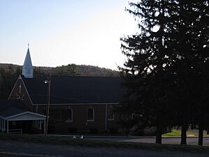
St. Thomas Aquinas Church in Ashville
|
|

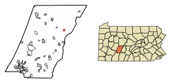
Location of Ashville in Cambria County, Pennsylvania.
|
|

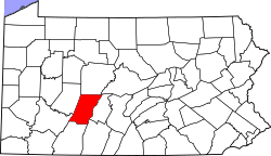
Map of Cambria County, Pennsylvania
|
|
| Country | United States |
| State | Pennsylvania |
| County | Cambria |
| Settled | 1842 |
| Incorporated | 1887 |
| Government | |
| • Type | Borough Council |
| Area | |
| • Total | 0.18 sq mi (0.47 km2) |
| • Land | 0.18 sq mi (0.47 km2) |
| • Water | 0.00 sq mi (0.00 km2) |
| Elevation | 1,680 ft (510 m) |
| Population
(2020)
|
|
| • Total | 213 |
| • Density | 1,163.93/sq mi (450.27/km2) |
| Time zone | UTC-5 (Eastern (EST)) |
| • Summer (DST) | UTC-4 (EDT) |
| Zip code |
16613
|
| Area code(s) | 814 |
| FIPS code | 42-03296 |
| GNIS feature ID | 1215008 |
Ashville is a small town, also called a borough, located in Cambria County, Pennsylvania, in the United States. It is part of a larger area around Johnstown, Pennsylvania. However, it is actually closer to the city of Altoona and is sometimes thought of as a nearby community. In 2020, about 213 people lived in Ashville.
Geography of Ashville
Ashville is found in the northeastern part of Cambria County. It sits in a valley near Clearfield Creek. This creek flows north and eventually joins the West Branch Susquehanna River.
A special natural line called the eastern continental divide is very close to Ashville. This line separates which way rainwater flows. On one side, water goes to the Atlantic Ocean. On the other, it goes to the Gulf of Mexico.
The United States Census Bureau says that Ashville is quite small. Its total area is about 0.46 square kilometers (0.18 square miles). All of this area is land, with no large bodies of water.
People of Ashville
| Historical population | |||
|---|---|---|---|
| Census | Pop. | %± | |
| 1890 | 289 | — | |
| 1900 | 393 | 36.0% | |
| 1910 | 384 | −2.3% | |
| 1920 | 447 | 16.4% | |
| 1930 | 486 | 8.7% | |
| 1940 | 511 | 5.1% | |
| 1950 | 441 | −13.7% | |
| 1960 | 422 | −4.3% | |
| 1970 | 409 | −3.1% | |
| 1980 | 383 | −6.4% | |
| 1990 | 306 | −20.1% | |
| 2000 | 279 | −8.8% | |
| 2010 | 227 | −18.6% | |
| 2020 | 213 | −6.2% | |
| U.S. Decennial Census | |||
The study of people in a place is called demographics. The population of Ashville has changed over the years. In 2010, there were 227 people living in the borough. These people lived in 102 different homes.
Most people in Ashville are White. A small number of people are Black or African American, Native Hawaiian, or from other backgrounds. About 0.9% of the population identified as Hispanic or Latino.
About 27.5% of the homes had children under 18 living there. Many homes were married couples living together. Other homes included single parents or individuals living alone.
The age of the people in Ashville varies. About 24.2% of the population was under 18 years old. About 23.3% were 65 years or older. The average age in Ashville was 40 years old. For every 100 females, there were about 102.7 males.
See Also
 In Spanish: Ashville (Pensilvania) para niños
 | Mary Eliza Mahoney |
 | Susie King Taylor |
 | Ida Gray |
 | Eliza Ann Grier |


