
Aspen Mountain (Wyoming) facts for kids
Quick facts for kids Aspen Mountain |
|
|---|---|

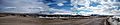
Aspen Mountain Wyoming, from the north.
|
|
| Highest point | |
| Elevation | 8,657 ft (2,639 m) |
| Geography | |

Aspen Mountain
Location in Wyoming
|
|
| Climbing | |
| Easiest route | Access Road |
Aspen Mountain is a long mountain in Sweetwater County, Wyoming. It's about 12 miles (19 km) south of Rock Springs, Wyoming. The mountain gets its name from patches of Quaking Aspen trees. These trees grow on the north and south sides of the mountain. Some old maps even called it "Quaking Aspen Mountain." Today, Aspen Mountain is mostly used for radio signals. It has many towers for different companies and services.
Contents
Why is Aspen Mountain Important?

Aspen Mountain is a key spot for communication. It holds special equipment called "repeaters." These repeaters help local police, fire, and highway patrol services talk to each other. If the repeaters on Aspen Mountain stop working, they can automatically switch to backup ones on nearby Wilkins Peak. This makes sure emergency services can always communicate.
The mountain also has repeaters for amateur radio users, often called "ham radio" operators.
The Big Radar Station
One of the most noticeable things on Aspen Mountain is a large radar station. The FAA (which manages air traffic) runs this station. It helps track airplanes in the sky. This radar site is always watched by employees, 24 hours a day, every day of the year. In winter, when snow is deep, they often use special vehicles called Snowcats to get around.
Getting to Aspen Mountain
You can reach Aspen Mountain in a few ways. From Rock Springs, you can take a road called Little Bitter Creek Road. Another way is using county highway 4-27, which starts from Wyoming Highway 430. If you're coming from the south, you can use US 191.
The roads are usually in good condition most of the year. But in winter, it's a good idea to use a four-wheel drive vehicle because of snow. The road on the mountain itself is known as "Radar Tower Road."
Most of the mountain is open for visitors. However, some areas are fenced off. These include the radio towers and the FAA radar station. These spots have "no trespassing" signs to keep people safe.
Radio and TV Stations on the Mountain


Aspen Mountain is home to many radio and TV transmitters. These towers send out signals for different stations.
- Radio Stations (FM):
* KZUW 88.5 FM (from Reliance, Wyoming) * KUWZ 90.5 FM (from Rock Springs) * KQSW 96.5 FM (from Rock Springs) * KSIT 99.7 FM (from Rock Springs) * KMRZ-FM 106.7 FM (from Superior, Wyoming) - This is the only FM station on the western side of the mountain.
- Television Stations:
* KGWR Channel 13 - CBS (from Rock Springs) * K45IA Channel 45 - The CW (from Rock Springs)
- Weather Radio:
* KXI34 162.550 MHz - This is a NOAA Weather Radio station. It broadcasts weather alerts and information. The National Weather Service office in Riverton, Wyoming operates it.
Images for kids
-
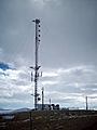
The All-Hazards NOAA weather station KXI34 radio tower is shared with KUWZ.
-
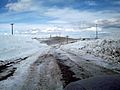
The road in the winter is often impassable without a four wheel drive vehicle.
-
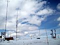
The west central radio towers, mostly used by local and state companies.
-
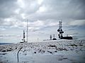
The far western side of the mountain houses radio towers owned by telephone companies such as Qwest.
-
Arrowhead Springs, Wyoming, with Aspen Mountain to the south.


