
Wilkins Peak facts for kids
Quick facts for kids Wilkins Peak |
|
|---|---|

Wilkins Peak
|
|
| Highest point | |
| Elevation | 7,650 ft (2,330 m) |
| Geography | |

Wilkins Peak
Location in Wyoming
|
|
| Climbing | |
| Easiest route | Access Road |

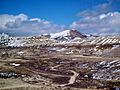
Wilkins Peak is a small mountain in Sweetwater County, Wyoming. It sits between the cities of Green River and Rock Springs. This peak is mostly used for radio and television signals. It also helps with communication for the FAA (which manages air travel) and EMS (emergency medical services).
In 2003, a radio tower on the peak was accidentally knocked down. This tower belonged to Wyoming Public Radio. Wilkins Peak is open all year, as long as the weather is good. You can reach it by several roads. Besides its use for radio, the mountain is a great spot for mountain biking and hiking.
Contents
Mountain Geology: What's Wilkins Peak Made Of?
Wilkins Peak is part of a larger area called the Green River Formation. This formation was created a very long time ago, during the Eocene epoch. Back then, this area was covered by a huge lake called Lake Gosiute.
Like its neighbor, Aspen Mountain, Wilkins Peak is part of the Rock Springs Uplift. This means the land here was pushed up over time. Some of the biggest deposits of oil shale and trona (a mineral used to make glass and detergents) are found near the mountain. Wilkins Peak even has its own special part of the Green River Formation, called the Wilkins Peak Formation.
The peak itself is about 2,332 meters (7,650 feet) high. It is about 13.2 kilometers (8.18 miles) from Rock Springs, Wyoming. It is also about 10.1 kilometers (6.3 miles) from Green River, Wyoming.
Radio and TV Signals from the Peak
Wilkins Peak is home to many radio towers for FM radio and television stations. Some of the radio stations here include KYCS (95.1 FM), KFRZ (92.1 FM), and KZWB (97.9 FM). Another station, KTME 89.5, started broadcasting from the mountain in 2010. It is part of Pilgrim Radio. KREO 93.5 is one of the newest stations on the peak.
Several television translators also send their signals from two small towers on Wilkins Peak. A translator is like a booster that helps TV signals reach more homes. The religious TV network TBN has a translator here called K35CN.
Before 2009, K22BK, the local PBS TV translator, also broadcast from Wilkins Peak. However, K22BK moved to White Mountain in 2009. A new TV station, K33IX-D on channel 33, began broadcasting from the peak in late 2009. It shows Christian programs from EICB TV. K35CN and K22BK stopped broadcasting after the switch to digital TV in 2009.
FM Radio Translators
Besides the main FM radio stations, Wilkins Peak also has three smaller FM translators. These translators help boost signals for other stations.
- K205FE broadcasts Christian music on 88.9 FM.
- K285FG retransmits programs from the AM station KUGR on 104.9 FM.
- K290BJ carries programs from KZWB 97.9 FM.
Other Radio Uses
Wilkins Peak also has repeater towers for local police, fire, and EMS services. Repeaters help these important radio signals travel further. These emergency radio repeaters work together with others on nearby Aspen Mountain and Mansface Hill.
In 2003, a truck delivering propane accidentally hit the KUWZ tower. This caused the tower to fall and knocked out power to the mountain for several hours. The KUWZ station later moved its transmitter to Aspen Mountain.
Getting to Wilkins Peak
Wilkins Peak is not gated, so you can visit it easily. You can reach it using an unpaved road called Wilkins Peak Road. This road starts near U.S. Route 191 southwest of Rock Springs, Wyoming.
Another unpaved road to the mountain begins in the Scott's Bottom Nature Area in Green River, Wyoming. The peak is open all year, as long as the weather allows. The road from Green River is a bit rougher. It has steep parts, poor surfaces, and can have lots of off-road vehicle traffic.
Wilkins Peak is a popular spot for hiking and mountain biking. Many smaller roads and trails branch off from the peak. These trails offer different levels of challenge for everyone.
Wilkins Peak Trail System
The Sweetwater Mountain Bike Association helps manage the Wilkins Peak Trail System. This system has over 24 miles of trails located just west of Wilkins Peak. These trails are mostly accessed from the Green River area. They offer a mix of easy and challenging paths for all riders. You can get free trail maps at the Green River Chamber of Commerce Visitor Center.
Images for kids
-
Wilkins Peak
-
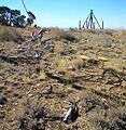
The remains of the KUWZ tower still present in 2005
