Aspinwall, Pennsylvania facts for kids
Quick facts for kids
Aspinwall, Pennsylvania
|
|
|---|---|
|
Borough
|
|

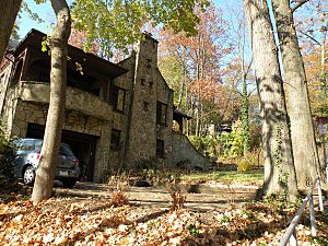
The Sauer Buildings Historic District located between 607–717 Center Avenue in Aspinwall.
|
|
| Motto(s):
The Town That Pride Built
|
|

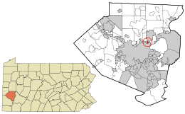
Location in Allegheny County and the U.S. state of Pennsylvania
|
|
| Country | United States |
| State | Pennsylvania |
| County | Allegheny |
| Incorporated | December 28, 1892 |
| Named for | George Aspinwall |
| Area | |
| • Total | 0.39 sq mi (1.00 km2) |
| • Land | 0.35 sq mi (0.91 km2) |
| • Water | 0.04 sq mi (0.09 km2) |
| Elevation | 758 ft (231 m) |
| Population
(2020)
|
|
| • Total | 2,916 |
| • Density | 8,307.69/sq mi (3,209.21/km2) |
| Time zone | UTC-5 (EST) |
| • Summer (DST) | UTC-4 (EDT) |
| ZIP code |
15215
|
| Area codes | 412, 724 |
| FIPS code | 42-03320 |
| School District | Fox Chapel Area |
| Website | http://www.aspinwallpa.com |
Aspinwall is a small town, also called a borough, located right by the Allegheny River in Allegheny County, Pennsylvania, United States. It's part of the bigger Pittsburgh area. In 2020, about 2,916 people lived there.
Contents
History of Aspinwall

In the mid-1880s, the land that is now Aspinwall was mostly owned by the family of James Ross. At that time, the steel industry in Pittsburgh was growing fast. Henry Warner, who managed the Allegheny County Workhouse, had an idea. He wanted to create a new neighborhood along the river.
Founding the Town
Warner traveled to New York to talk with Annie Aspinwall. He bought about 155 acres (0.63 square kilometers) of land from her. In 1890, he started the Aspinwall Land Company. People from Pittsburgh, mostly from well-off families, bought plots of land from the 60 available spots.
By 1890, the new town had about 400 residents. Most of them were young couples with children. The local government, O'Hara Township, found it hard to provide services to this quickly growing area. So, in 1892, 40 residents signed a paper. They asked for the community to become its own self-governing unit, called "The Borough of Aspinwall."
Aspinwall officially became a borough on December 28, 1892. It separated from O'Hara Township.
Transportation and Growth
Aspinwall used to have streetcar service from Pittsburgh Railways. This service, called '94 Aspinwall', ran from around 1910 until November 12, 1960. It stopped when the 62nd Street Sharpsburg Bridge closed. A new bridge, the Senator Robert D. Fleming Bridge, was built, but it did not have tracks for streetcars.
From 1893 to 1905, Aspinwall grew in three stages. The first area to develop was closest to the Allegheny River. On September 25, 1905, a group of Aspinwall residents bought another 200 acres (0.81 square kilometers) of land. This land was then added to the borough.
Community Life
In its early days, Aspinwall had fun places like tennis courts and water fountains. During World War I, a group called the Patriots Committee of Aspinwall did something special. They bought wristwatches for about 164 Aspinwall men who joined the military. After the war, Aspinwall held its own victory parade and a special service to remember its soldiers.
Geography of Aspinwall
Aspinwall is located at coordinates 40°29′35″N 79°54′11″W. The U.S. Census Bureau says the borough covers a total area of about 0.4 square miles (1.0 square kilometer). Of this, 0.3 square miles (0.91 square kilometers) is land, and 0.04 square miles (0.09 square kilometers) is water. The average height above sea level is 758 feet (231 meters).
Neighboring Communities
Aspinwall is surrounded by several other towns and areas:
- To the west is Sharpsburg.
- To the northwest, north, and east is O'Hara Township.
- To the east is the northern part of the Pittsburgh neighborhood Lincoln-Lemington-Belmar.
- Across the Allegheny River to the south are the Pittsburgh neighborhoods of Highland Park and the southern part of Lincoln-Lemington-Belmar.
Population Information
| Historical population | |||
|---|---|---|---|
| Census | Pop. | %± | |
| 1900 | 1,231 | — | |
| 1910 | 2,592 | 110.6% | |
| 1920 | 3,170 | 22.3% | |
| 1930 | 4,263 | 34.5% | |
| 1940 | 4,716 | 10.6% | |
| 1950 | 4,084 | −13.4% | |
| 1960 | 3,727 | −8.7% | |
| 1970 | 3,541 | −5.0% | |
| 1980 | 3,284 | −7.3% | |
| 1990 | 2,880 | −12.3% | |
| 2000 | 2,960 | 2.8% | |
| 2010 | 2,801 | −5.4% | |
| 2020 | 2,916 | 4.1% | |
| Sources: | |||
As of the 2000 census, there were 2,960 people living in Aspinwall. There were 1,499 households, and 728 families. The population density was about 8,905 people per square mile (3,438 people per square kilometer). Most residents were White (98.11%).
The average household had 1.97 people, and the average family had 2.84 people. The median age in the borough was 40 years old.
Notable People from Aspinwall
- Robert Lepper, an artist and professor at Carnegie Mellon University.
- Chris Deluzio, a U.S. congressman.
See also
 In Spanish: Aspinwall (Pensilvania) para niños
 | Victor J. Glover |
 | Yvonne Cagle |
 | Jeanette Epps |
 | Bernard A. Harris Jr. |

