
Atafu facts for kids


Atafu is a beautiful group of 52 small coral islands, called islets. It's part of Tokelau, a country in the south Pacific Ocean. Atafu is about 500 kilometers (310 miles) north of Samoa.
It's the smallest of Tokelau's three main islands, covering an area of about 2.5 square kilometers (1 square mile). Atafu is an atoll, which means it's a ring-shaped coral island that surrounds a central body of water called a lagoon. This lagoon is quite large, about 15 square kilometers (5.8 square miles). The atoll is located about 800 kilometers (500 miles) south of the equator.
Contents
Life on Atafu
In 2016, about 541 people officially lived on Atafu. Most of the people there, about 78%, belong to the Congregational Christian Church. The main village where people live is on Atafu Island, located in the northwest part of the atoll. The first village was built at the southern end of the atoll. People built their homes along the lagoon shore to enjoy the cool trade winds.
Fishing Skills
Fishing is a very important part of life for the men of Atafu. They are incredibly skilled at it! They use many traditional fishing methods that have been passed down from fathers to sons for generations. They create clever lures, fish traps, and nets.
One special technique they use is called "noose fishing." They dangle a rope circle with a special knot in the water. When a big fish swims into the circle, attracted by bait, they tighten the rope around its body to catch it. They also build amazing canoes, which they use for their fishing trips.
Atafu's Geography

Atafu is located in an area of the Pacific where hurricanes can happen. In January 1914, a very strong storm hit the islands. It destroyed the church and most of the houses. It also wiped out many of the important coconut trees.
The atoll is shaped a bit like a triangle. Its lagoon is about 5 kilometers (3 miles) from north to south and 4 kilometers (2.5 miles) from east to west at its widest part. Atafu is very low-lying, reaching a maximum height of only about 5 meters (16 feet) above sea level. It's covered with lots of coconut palms and other trees, with plants similar to those found on many small islands in the central Pacific. You can find lizards, rats, and many seabirds on Atafu. The waters around the atoll are full of many different kinds of fish.
The eastern side of the lagoon is almost one long, thin strip of land, with just a small break in the middle. The western side is different, made up of a reef and several separate islands. These include the V-shaped Atafu Island in the north, Alofi (which stretches into the lagoon), and the L-shaped Fenualoa in the southwest. A smaller island called Tamaseko is inside the lagoon, near Alofi.
The reef connecting the islands is shallow enough that you can sometimes walk between them when the tide is low. This also means that boats can't easily enter the lagoon. However, the ocean gets very deep close to the reef, which is good for anchoring boats. But it can also make the seas rough near the reef. Because the atoll is so flat and in a tropical cyclone area, storms can sometimes cause damage to the island's buildings.
Important Bird Area
About 70 hectares (173 acres) of the southern and southwestern parts of Atafu have been named an Important Bird Area (IBA) by BirdLife International. This is because many birds come here to breed. You can find large groups of brown and black noddies, and common white terns. In 2011, it was estimated that about 30,000 pairs of these birds were breeding there!
Islands of Atafu
Atafu Atoll is made up of many small islands. Here are some of them:
- Fogalaki i Lalo
- Fogalaki-Matangi (Fogalaki i Matagi)
- Te Oki
- Te Hepu
- Laualalava
- Te Kapi
- Na Utua
- Motu Atea
- Motu Fakalalo
- Tama Hakea
- Hakea Lahi ki Matagi
- Hakea O Himi
- Malatea
- Kenakena
- Malo o Futa
- Motu o Te Lakia
- Komulo
- Hakea o Apelamo
- Na Hapiti
- Niuefa
- Fenualoa
- Te Puka
- Tamaheko
- Te Alofi
- Tulua a Kovi
- Tagi a Kuli
- Hakea o Himi
- Tulua a Kava
- Motu o te Niu
- Malatea
- Hakea o Hoi
- Hakea o Fata
- Kenakena
- Matu o Tenumi
- Matu o te Lakia
- Motu Fakaka kai
- Malo o Futa
- Malo o Futa
- Motu o te Fala
- Tafega
- Komulo
- Hakela Lahi i Lalo
- Hotoma
- Hakea o Apelamo
- Na Hapiti
- Niuefa
- Fenualoa
- Te Puka
- Tamaheko
- Te Alofi
- Ulugagie
- Atafu Village
Atafu's History

It's believed that Polynesians visited Atafu a very long time ago, but they might not have lived there permanently. The first European to discover the atoll was John Byron on June 21, 1765. He was on a ship called HMS Dolphin. Byron didn't find anyone living on the island at that time and named it "Duke of York's Island." Later, Atafu was settled by a couple named Tonuia and Lagimaina, along with their seven children.
Between 1856 and 1979, the United States claimed Atafu and other Tokelauan islands as their own. However, in 1979, the U.S. agreed that Tokelau was part of New Zealand. A special agreement called the Treaty of Tokehega was made to set the sea border between Tokelau and American Samoa.
Atafu has also seen some interesting events. On August 26, 2007, a man named Ralph Tuijn, who was trying to row a boat all the way from South America to Australia, ended up crashing on Atafu. Then, on November 26, 2010, three teenage boys from Atafu were rescued after they had drifted for 50 days in the Pacific Ocean, traveling about 1,300 kilometers (800 miles)!
See also
 In Spanish: Atafu para niños
Images for kids
-
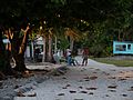
Dawn in the main street
-
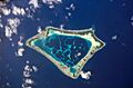
Satellite image of Atafu
-
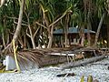
A traditional canoe or vaka
