Atalissa, Iowa facts for kids
Quick facts for kids
Atalissa, Iowa
|
|
|---|---|
 |
|

Location of Atalissa, Iowa
|
|
| Country | |
| State | |
| County | Muscatine |
| Area | |
| • Total | 0.14 sq mi (0.36 km2) |
| • Land | 0.14 sq mi (0.36 km2) |
| • Water | 0.00 sq mi (0.00 km2) |
| Elevation | 659 ft (201 m) |
| Population
(2020)
|
|
| • Total | 296 |
| • Density | 2,129.50/sq mi (821.29/km2) |
| Time zone | UTC-6 (Central (CST)) |
| • Summer (DST) | UTC-5 (CDT) |
| ZIP code |
52720
|
| Area code(s) | 563 |
| FIPS code | 19-03385 |
| GNIS feature ID | 0454271 |
Atalissa is a small city in Muscatine County, Iowa, United States. In 2020, about 296 people lived there. It is part of the wider Muscatine area.
Contents
History of Atalissa
Atalissa was officially planned out in 1859. This process is called "platting." The city was named by its founder, William Lundy. He named it after a mining town in California. That town was, in turn, named after an Indian queen called Atalissa.
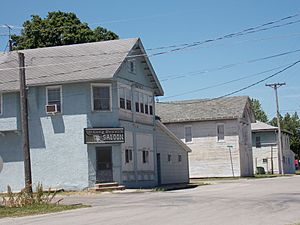
From 1974 to 2009, Atalissa was home to a group of men with intellectual disabilities. They worked at a nearby turkey processing plant. They lived together in an old schoolhouse. Each workday, they were taken to the plant. After paying for their living costs, they received a small amount of money each month.
In 2009, state agencies moved these men to better places. This happened after it was found that their living conditions needed to be improved. What happened to these men had a big impact on social services in Iowa. Their experiences and the court case that followed became the subject of a documentary film. The film is called The Men of Atalissa.
Geography of Atalissa
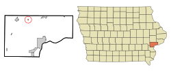
Atalissa is located in Iowa at these coordinates: 41°34′18″N 91°10′0″W / 41.57167°N 91.16667°W.
The United States Census Bureau says the city covers a total area of about 0.14 square miles (0.36 square kilometers). All of this area is land.
People of Atalissa
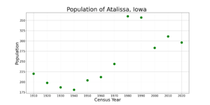
| Historical populations | ||
|---|---|---|
| Year | Pop. | ±% |
| 1910 | 220 | — |
| 1920 | 198 | −10.0% |
| 1930 | 187 | −5.6% |
| 1940 | 181 | −3.2% |
| 1950 | 204 | +12.7% |
| 1960 | 212 | +3.9% |
| 1970 | 244 | +15.1% |
| 1980 | 360 | +47.5% |
| 1990 | 357 | −0.8% |
| 2000 | 283 | −20.7% |
| 2010 | 311 | +9.9% |
| 2020 | 296 | −4.8% |
| Source: and Iowa Data Center Source: |
||
Population in 2020
According to the census in 2020, 296 people lived in Atalissa. There were 115 households and 81 families. The city had about 2,178 people per square mile (841 per square kilometer). There were 117 housing units.
Most people in Atalissa were White (92.2%). A small number were Black or African American (0.3%). About 0.7% were from other races, and 6.8% were from two or more races. People of Hispanic or Latino background made up 7.4% of the population.
Out of 115 households, 37.4% had children under 18 living with them. About 52.2% were married couples. The median age in the city was 35.2 years. About 30.1% of residents were under 20. The population was 51.4% male and 48.6% female.
Education
The West Liberty Community School District is in charge of the public schools in Atalissa.
See also
 In Spanish: Atalissa para niños
 | George Robert Carruthers |
 | Patricia Bath |
 | Jan Ernst Matzeliger |
 | Alexander Miles |


