
Aurora, Kansas facts for kids
Quick facts for kids
Aurora, Kansas
|
|
|---|---|

Location within Cloud County and Kansas
|
|

|
|
| Country | United States |
| State | Kansas |
| County | Cloud |
| Founded | 1880s |
| Incorporated | 1910 |
| Named for | Aurora, Illinois |
| Area | |
| • Total | 0.10 sq mi (0.26 km2) |
| • Land | 0.10 sq mi (0.26 km2) |
| • Water | 0.00 sq mi (0.00 km2) |
| Elevation | 1,499 ft (457 m) |
| Population
(2020)
|
|
| • Total | 56 |
| • Density | 560/sq mi (215/km2) |
| Time zone | UTC-6 (CST) |
| • Summer (DST) | UTC-5 (CDT) |
| ZIP code |
67417
|
| Area code | 785 |
| FIPS code | 20-03425 |
| GNIS ID | 2394035 |
Aurora is a small city in Cloud County, Kansas, United States. In 2020, about 56 people lived there. It's a quiet place with a rich history.
Contents
History of Aurora
Aurora was founded in the 1880s. It got its name from settlers who came from a city called Aurora, Illinois.
A railroad line was built through Aurora in 1887 by the Atchison, Topeka and Santa Fe Railway. This railway later joined with another company in 1996 to become the BNSF Railway. Even today, many local people still call it the "Santa Fe" railroad.
The first post office in Aurora opened in 1886. For a short time, from 1886 to 1888, it was known as the St. Peter post office.
Geography of Aurora
Aurora is a very small city. According to the United States Census Bureau, its total area is about 0.10 square miles (0.26 square kilometers). All of this area is land.
People of Aurora
| Historical population | |||
|---|---|---|---|
| Census | Pop. | %± | |
| 1910 | 269 | — | |
| 1920 | 275 | 2.2% | |
| 1930 | 256 | −6.9% | |
| 1940 | 274 | 7.0% | |
| 1950 | 221 | −19.3% | |
| 1960 | 150 | −32.1% | |
| 1970 | 120 | −20.0% | |
| 1980 | 130 | 8.3% | |
| 1990 | 101 | −22.3% | |
| 2000 | 79 | −21.8% | |
| 2010 | 60 | −24.1% | |
| 2020 | 56 | −6.7% | |
| U.S. Decennial Census | |||
What the 2020 Census Showed
In 2020, the census counted 56 people living in Aurora. There were 13 households and 7 families. About 30.8% of the households had children under 18. Many households (53.8%) were married couples living together.
The population included people of different ages:
- 35.7% were under 18 years old.
- 14.3% were 65 years or older.
The average age in Aurora was about 30.5 years.
What the 2010 Census Showed
In 2010, there were 60 people living in Aurora. There were 24 households and 17 families. About 37.5% of the households had children under 18.
The average age in the city was 38 years.
- 33.3% of people were under 18.
- 11.7% were 65 years or older.
There were slightly more males (53.3%) than females (46.7%) in the city.
Education in Aurora
Students in Aurora attend public schools in the Concordia USD 333 school district. The high school in Concordia is known as Concordia High School, and their sports teams are called the Panthers.
Images for kids
-
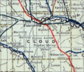
This map from 1915-1918 shows the railroad lines in Cloud County.

See also
 In Spanish: Aurora (Kansas) para niños
