
Aurora Site facts for kids

Aurora/Old Fort Site (16th century Wendat Huron ancestral village), Kennedy Road, south of Vandorf Side Road, Whitchurch–Stouffville, ON, looking east.
|
|

Location in Ontario
|
|
| Location | Whitchurch–Stouffville, Regional Municipality of York, Ontario, Canada |
|---|---|
| Region | Regional Municipality of York, Ontario |
| Coordinates | 44°0′28″N 79°20′16″W / 44.00778°N 79.33778°W |
| History | |
| Abandoned | Before 1800s |
| Periods | Late Precontact Period, c. 1550–1575 |
| Cultures | Huron-Wendat |
| Site notes | |
| Excavation dates | 1846/1888/1901; 1947, 1957 |
| Archaeologists | William Brodie, John Norman Emerson |
The Aurora Site is an important historical place. It is also known by names like "Old Fort" or "Hill Fort." This site was once a village of the Huron-Wendat people. They lived here in the 1500s.
You can find the Aurora Site in Whitchurch–Stouffville, Ontario, Canada. This is about 30 kilometers north of Toronto. The village was built near a river that flows into the East Holland River.
Contents
What Was the Aurora Site Like?
The Aurora Site was a large village covering about 3.4 hectares (8.4 acres) of land. The people who lived there built strong defenses. They used multiple rows of tall wooden fences called palisades. These palisades helped protect their homes and families.
When Was the Aurora Site Used?
Archaeologists believe the Huron-Wendat people moved to the Aurora Site around 1625. They likely came from another village called the Mantle Site. This older village was about nine kilometers away. The Aurora Site was used at the same time as another nearby village, the Ratcliff Site.
Where is the Aurora Site Located Today?
Today, the Aurora Site is at the southeast corner of Kennedy Road and Vandorf Side Road. This is east of the small community of Vandorf. It's a key spot in the history of Whitchurch–Stouffville.
The Rouge River Trail and Its Importance
The Rouge River trail was a very old path. The Huron people used it long ago. Later, French explorers also used this trail. It helped them travel between Lake Ontario and Lake Simcoe or Georgian Bay. The Aurora Site was right on this important trail.
How Did the Trail Help Travel?
This trail was one of the busiest routes for travel. It connected different waterways. People could go from the mouth of the Rouge River all the way north. They would then cross a land area to reach the East Branch of the Holland River. This made travel and trade much easier.

Discovering the Aurora Site's Past
For many years, people found artifacts at the Aurora Site. In the 1700s and early 1800s, many items were taken by collectors. An old report from 1885 mentions that many burials were found here. Another smaller burial site was also found nearby.
Early Archaeological Work
William Brodie was an archaeologist who taught himself. He visited the Old Fort Site in 1846. He wrote two reports about what he found there. Brodie noted that a huge amount of historical material was collected from sites in York County.
Much of what was found ended up in museums far away. Some went to Europe, some to the United States, and some to Laval University. Sadly, a lot of the collected items were lost over time.
Mapping and Excavations
In 1930, an amateur archaeologist named Peter Pringle made a full map of the site. Later, in 1947 and 1957, the University of Toronto did full excavations. These digs helped scientists learn a lot about the site.
The 1947 dig was the first time university students helped with an excavation. It was led by John Norman Emerson. His important research about the Aurora Site helped shape what we know today.
What We Learned from the Aurora Site
The excavations at the Aurora Site helped archaeologists understand the Huron-Wendat people better. Scientists now believe that the Wendat people came together in this area. Before, some thought they came from further east, near the St. Lawrence River.
New Discoveries and Ideas
More recent findings have added to this knowledge. Discoveries at the Ratcliff Site and the Mantle Site in the late 1900s and early 2000s showed more ancestral Wendat villages. New technologies like radiocarbon dating help scientists figure out exactly when these sites were used.
Some researchers now think the Mantle Site was used from 1587 to 1623. However, not everyone agrees on these exact dates. Scientists continue to study these sites to learn more about the past.
Images for kids
-
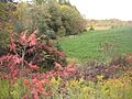
Aurora/Old Fort Site (16th century Wendat Huron ancestral village), Kennedy Road, south of Vandorf Side Road, Whitchurch–Stouffville, ON, looking east.
-
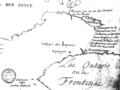
Rouge Trail Map, c. 1673 by Louis Jolliet
