Lake Simcoe facts for kids
Quick facts for kids Lake Simcoe |
|
|---|---|
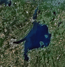
Satellite View.
|
|
| Location | Ontario |
| Coordinates | 44°26′12″N 079°20′21″W / 44.43667°N 79.33917°W |
| Type | Freshwater |
| Etymology | Ouentironk, a Huron (Wyandot) word meaning "beautiful water" |
| Primary inflows | Holland River, Talbot River |
| Primary outflows | Severn River |
| Catchment area | 2,840 km2 (1,100 sq mi) |
| Basin countries | Canada |
| Max. length | 30 km (19 mi) |
| Max. width | 25 km (16 mi) |
| Surface area | 722 km2 (279 sq mi) |
| Average depth | 15 m (49 ft) |
| Max. depth | 41 m (135 ft) |
| Water volume | 11.6 km3 (2.8 cu mi) |
| Shore length1 | 240 kilometres (150 mi) |
| Surface elevation | 219 m (719 ft) |
| Islands | Georgina Island, Thorah Island, Strawberry Island, Snake Island, Fox Island, Helmers Island, Grape Island |
| Settlements | Orillia, Barrie |
| 1 Shore length is not a well-defined measure. | |
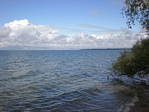
Lake Simcoe (French: Lac Simcoe) is a large lake in southern Ontario, Canada. It's the fourth biggest lake entirely within Ontario. When Europeans first arrived in the 1600s, the Wyandot (Huron) people called it Ouentironk, which means "Beautiful Water." It was also known as Lake Taronto before being renamed by John Graves Simcoe in 1793. He was the first Lieutenant-Governor of Upper Canada and named the lake after his father, Captain John Simcoe.
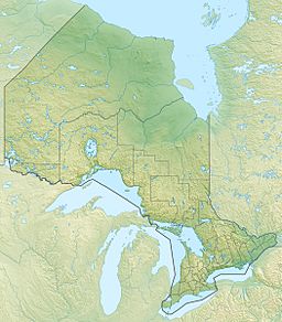
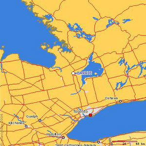
The lake is surrounded by Simcoe County, Durham Region, and York Region. The city of Barrie sits on Kempenfelt Bay, and Orillia is at the entrance to Lake Couchiching. Many people live in the area around the lake, including parts of the Greater Toronto Area.
Towns like Georgina are along the south shore, with smaller communities such as Keswick, Sutton, Jackson's Point, Pefferlaw, and Udora. Innisfil is on the western shore, and towns like Beaverton, Brechin, and Lagoon City are on the east side.
Contents
History of Lake Simcoe
Lake Simcoe is what's left of a much larger, ancient lake called Lake Algonquin. This huge lake also included areas that are now Lake Huron, Lake Michigan, Lake Superior, Lake Nipigon, and Lake Nipissing. When the ice from the last ice age melted, water levels dropped a lot, leaving behind the lakes we see today.
Names Through Time
When Europeans first came in the 1600s, the Wyandot (Huron) people called the lake Ouentironk, meaning "Beautiful Water." Later, a map from 1675 by Pierre Raffeix called it Lac Taronto. Other maps also used names like Lake Taronto or Tarontos Lac.
The word "Taronto" comes from an Iroquoian expression that means "gateway" or "pass." This name first referred to The Narrows, a narrow channel where Lake Simcoe flows into Lake Couchiching. Some experts say the Mohawk phrase tkaronto means "where there are trees standing in the water." This describes how the Hurons and other native groups used to drive stakes into the water at The Narrows to create fish traps. These traps have been used for over 4,000 years!
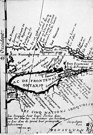
The name 'Toronto' eventually became the name of the city of Toronto. This happened because of the Toronto Carrying-Place Trail, a portage route that went from Lake Ontario through Lake Simcoe to Georgian Bay. The Severn River, which flows out of Lake Simcoe, was once called 'Rivière de Toronto'.
Later, French traders called the lake Lac aux Claies, meaning "Lake of Grids" or "Trellises." This was because of the Huron fishing weirs (traps) in the lake. The lake kept this name until Upper Canada was formed. In 1793, John Graves Simcoe renamed it after his father, Captain John Simcoe. Captain Simcoe was a Royal Navy officer who passed away in 1759.
Lake Simcoe's Shape
Lake Simcoe is about 30 kilometres (19 mi) long, 25 kilometres (16 mi) wide, and covers 722 square kilometres (279 sq mi). It looks a bit like a fist with the index finger and thumb sticking out. The "thumb" is Kempenfelt Bay on the west side. The "wrist" connects to Lake Couchiching in the north. The "extended finger" is Cook's Bay in the south.
Lake Couchiching was once thought of as part of Lake Simcoe, but the narrow channel between them makes it a separate lake. This narrow area, known as "where trees stand in the water," was a very important fishing spot for the First Nations people.
The idea of "where trees stand in the water" likely came from the Huron people. They would put fresh-cut saplings (young trees) into the water and mud to make fish traps. These saplings would sprout branches and leaves, staying alive for some time, making it look like trees were growing in the water.
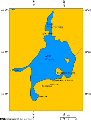
Many rivers in southern Ontario flow into Lake Simcoe, bringing water from an area of 2,581 square kilometres (997 sq mi). From the east, the Talbot River is very important. It's part of the Trent–Severn Waterway, which connects Lake Simcoe to the Kawartha lakes and Lake Ontario.
The Severn River is the only river that flows out of Lake Simcoe, leading to Georgian Bay, which is part of Lake Huron. Lake Simcoe itself is not one of the Great Lakes. The canal locks of the Trent-Severn Waterway allow boats to travel between Lake Simcoe and Georgian Bay.
Here are some of the creeks and rivers that flow into Lake Simcoe:
- Black River
- Bluffs Creek
- Beaver River
- Holland River
- Maskinongé River
- Pefferlaw River
- Talbot River
- White's Creek
- Duclos Creek
- Burnie Creek
- Virginia CreekA
- Virginia CreekB
- Virginia CreekC
- Virginia CreekD
Islands in Lake Simcoe
Lake Simcoe has several islands. The largest is Georgina Island, which, along with Snake Island and Fox Island, forms a reserve for the Chippewas of Georgina Island First Nation.
Other smaller islands include Thorah Island (a popular spot for cottages), Strawberry Island, Helmers Island, and Fox Island. Interestingly, Pope John Paul II stayed on Strawberry Island for four days before World Youth Day 2002 in Toronto.
Before the Trent–Severn Waterway was finished, the water level in Lake Simcoe was much lower. People could even walk or use wagons to cross to the mainland in some shallow areas. But after the waterway was completed, the water level rose by several feet.
Grape Island is located near Orillia on the north end of the lake. To the east of Grape Island is Goffatt Island, a small private island.
Georgina, Snake, and Fox Islands are in York Region. Thorah Island is in Durham Region. Strawberry Island and Helmers Island are privately owned but are within Ramara in Simcoe County. Grape Island is in Orillia, and Goffatt Island is in Ramara; both are privately owned.
Recreation and Fun
Lake Simcoe is a popular place for many fun activities. It doesn't have much commercial shipping, but it's a hub for recreation.
Winter Activities
In winter, the lake completely freezes over. This makes it a fantastic spot for ice fishing competitions. It's known as one of the best lakes in Ontario for ice fishing.
Summer Activities
During the summer, fishing is still a big draw. People also enjoy poker runs (a type of boating event), jet-skiing, and other boating activities. Many summer cottages are around the lake, leading to lots of boating and other fun in the warmer months.
There are also several beaches that attract visitors, especially from the greater Toronto area. Lake Simcoe is known for having cleaner and warmer water than some nearby Lake Ontario beaches. Many beaches are also great for kite surfing. Willow Beach in Georgina, on the south shore, is one of the biggest and most popular public beaches on Lake Simcoe.
Sailing and Scuba Diving
There are seven yacht clubs (sailing clubs) around the lake. They host many regattas (sailing races), and there's a very active sailing community here.
Lake Simcoe is also well-known for scuba diving. The ship J. C. Morrison sank in 1857 and is a popular dive site near Centennial Beach. There are other good spots for freshwater divers too. Kempenfelt Bay is the most popular for scuba divers because it's the deepest part of the lake. The water clarity can change a lot, from very clear to almost no visibility.
Ecology of Lake Simcoe
When a lake is healthy, you'll find lots of cold-water fish like lake trout, herring, and whitefish. These fish are active and thriving. Lake Simcoe is sometimes called Canada's ice fishing capital because of its healthy fish populations.
Geology and How the Lake Formed
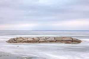
Lake Simcoe sits on ancient rock from the Ordovician period, which is a type of limestone. However, this rock is mostly covered by thick layers of sand and gravel left behind by glaciers. You can only see this bedrock along the shore of Georgina Island and Lake Couchiching.
The flow of water out of Lake Simcoe, at the north end of Lake Couchiching, is controlled by even older rock called Precambrian bedrock. Because this hard rock is there, the lake's outlet can't cut deeper, which means the lake has stayed at its current level over time. This is different from a nearby ancient lake called 'Lake Minesing', which mostly drained away because its outlet was on softer ground. Today, 'Lake Minesing' is mostly a swamp, but it floods each spring.
The land around Lake Simcoe is slowly rising because of something called isostatic rebound. This happens as the land "bounces back" after the heavy glaciers melted away. This rising land causes the water level of Lake Simcoe to slowly increase, especially at its south end. This is why the Holland Marsh, a very fertile area to the south, has deep layers of rich soil. The plants growing there have kept up with the rising water, making it a great place for farming vegetables. All the rivers and streams flowing into the lake have wide, deep mouths because the rising water has flooded their channels.
Environmental Challenges
Lake Simcoe has faced significant environmental problems, especially something called eutrophication. This happens when there are too many nutrients, like phosphorus, in the water. These nutrients come from both cities and farms.
When there's too much phosphorus, it causes too many aquatic plants and algae to grow. This makes the water warmer and lowers the oxygen levels, which is bad for fish and other lake creatures.
Lake Simcoe has also been invaded by several non-native species, including:
- zebra mussels
- purple loosestrife
- black crappie
- spiny water flea
- round goby
- rusty crayfish
- Eurasian milfoil
Zebra mussels, which arrived in North America around 1985, came from the Black and Caspian Sea areas. They likely traveled here in the ballast water of ships. Zebra mussels are especially harmful because they make the water clearer. This allows more sunlight to reach the bottom of the lake, causing even more algae and weeds to grow, which speeds up the eutrophication process.
Rainbow Smelt are another introduced species, first seen in the early 1960s. They are thought to compete with native fish like Lake Whitefish, which may have caused their populations to decline.
Many groups are working hard to help Lake Simcoe. These include the Lake Simcoe Environmental Management Strategy (LSEMS), the Lake Simcoe Conservation Foundation, and the Lake Simcoe Region Conservation Authority. Several towns around the lake rely on its water for drinking.
The Region of York is planning to build a new water treatment plant on the Holland River in Cook's Bay. This plant will help support new homes and businesses in the Lake Simcoe area.
Marine Police
Several police forces have marine units that patrol Lake Simcoe to keep everyone safe. These include the Ontario Provincial Police, South Simcoe Police Service, York Regional Police, Durham Regional Police, and Barrie Police. The Georgina Island Police also patrol Georgina, Fox, and Snake Islands and can help with marine issues near these islands. Grape Island, being part of Orillia, is patrolled by the OPP.
See also
 In Spanish: Lago Simcoe para niños
 | Laphonza Butler |
 | Daisy Bates |
 | Elizabeth Piper Ensley |


