Black River (York Region) facts for kids
Quick facts for kids Black River |
|
|---|---|

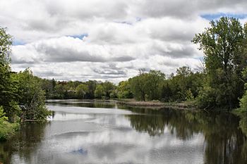
The river at the community of Sutton
|
|
|
Location of the mouth of the Black River in southern Ontario
|
|
| Country | Canada |
| Province | Ontario |
| Region | Central Ontario |
| Regional Municipalities |
|
| Municipalities |
|
| Physical characteristics | |
| Main source | Unnamed pond Whitchurch–Stouffville 291 m (955 ft) 44°03′20″N 79°20′07″W / 44.05556°N 79.33528°W |
| River mouth | Lake Simcoe Georgina 219 m (719 ft) 44°19′21″N 79°20′48″W / 44.32250°N 79.34667°W |
| Basin features | |
| River system | Great Lakes Basin |
| Basin size | 375 km2 (145 sq mi) |
The Black River is a river located in Central Ontario, Canada. It flows through the Regional Municipality of York and the Regional Municipality of Durham. This river is an important part of the Great Lakes Basin. It flows into Lake Simcoe, which is a large lake in Ontario. The entire area around the river is managed by the Lake Simcoe Region Conservation Authority. They help protect the river and its surroundings.
Contents
What is the Black River Watershed?
A watershed is an area of land where all the water drains into a common river, lake, or ocean. The Black River watershed covers about 375 square kilometres (145 square miles). This means all the rain and snow that falls in this area eventually flows into the Black River.
How Much Water Flows in the Black River?
Scientists measure how much water flows in the river. Near the town of Sutton, the river's average flow is about 2.61 cubic metres (92 cubic feet) of water per second. This measurement helps us understand the river's health and how much water it carries. Sometimes the flow is higher, and sometimes it's lower.
Where Does the Black River Flow?
The Black River starts from a small, unnamed lake. This lake is located on the Oak Ridges Moraine in Whitchurch-Stouffville, York Region. This area is close to a community called Cedar Valley.
The River's Journey North
From its start, the river flows northwest. It then goes north into East Gwillimbury. Next, it turns northeast and passes under Ontario Highway 48. It briefly crosses into the northwestern part of Uxbridge in Durham Region.
Returning to York Region
The river then flows under an old railway line, which used to be part of the Toronto and Nipissing Railway. After this, it returns to Georgina in York Region. It continues its journey north, passing over the Baldwin Dam near the community of Baldwin.
Reaching Lake Simcoe
Finally, the Black River flows through the community of Sutton. It then reaches its end, or mouth, at Lake Simcoe. This meeting point is between Briars Park to the west and Mossington Park to the east. From Lake Simcoe, the water eventually flows into Lake Couchiching and then the Severn River, which leads to Lake Huron.
Fun Things to Do Along the Black River
The Black River area offers some great spots for outdoor activities.
Baldwin Conservation Area
The Baldwin Conservation Area is a special protected area. It covers about 26 hectares (64 acres) of land. This area is located around a small reservoir, which is a lake created by the Baldwin Dam. It's a nice place to visit and enjoy nature.
Sutton-Zephyr Rail Trail
You can also explore the Sutton-Zephyr rail trail. This trail is built on an old railway line that used to cross the Black River. It's a great spot for walking, biking, or just enjoying the outdoors.
Smaller Streams Joining the Black River
Several smaller streams, called tributaries, flow into the Black River, adding to its water.
- Zephyr Creek (joins from the right side)
- Mount Albert Creek (joins from the right side)
- Harrison Creek (joins from the left side)
 | Victor J. Glover |
 | Yvonne Cagle |
 | Jeanette Epps |
 | Bernard A. Harris Jr. |


