Avant, Oklahoma facts for kids
Quick facts for kids
Avant, Oklahoma
|
|
|---|---|

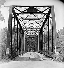
Bridge over Bird Creek, Avant. HAER photo.
|
|

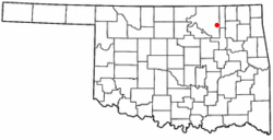
Location of Avant, Oklahoma
|
|
| Country | United States |
| State | Oklahoma |
| County | Osage |
| Area | |
| • Total | 1.10 sq mi (2.86 km2) |
| • Land | 1.04 sq mi (2.69 km2) |
| • Water | 0.07 sq mi (0.17 km2) |
| Elevation | 676 ft (206 m) |
| Population
(2020)
|
|
| • Total | 301 |
| • Density | 289.42/sq mi (111.72/km2) |
| Time zone | UTC-6 (Central (CST)) |
| • Summer (DST) | UTC-5 (CDT) |
| ZIP code |
74001
|
| Area codes | 539/918 |
| FIPS code | 40-03500 |
| GNIS feature ID | 2411654 |
Avant is a small town located in eastern Osage County, Oklahoma, United States. In 2020, about 301 people lived there. The town's population has changed over the years, but it remains a quiet community.
Contents
History of Avant, Oklahoma
Avant was founded thanks to a man named Ben Avant. He came from Gonzales, Texas, and started a ranch in the area in 1896. His wife, Rosalie Rogers, was of Cherokee-Osage heritage.
Oil Discovery and Growth
A big change happened in 1904 when oil was discovered nearby. This led to the "Avant oil field" becoming very important. Soon after, in 1905, a railroad called the Midland Valley Railroad (which later became part of the Missouri Pacific Railroad) reached Ben Avant's ranch. This made it easier to transport goods and people.
In 1906, a post office was opened, and the town officially got its name, Avant. The town really started to grow around 1909. By 1920, Avant's population reached its highest point with 1,071 people.
Later Years and Post Office
After 1920, the number of people living in Avant slowly started to decrease. Ben Avant, the town's founder, passed away in 1923.
In 2012, there was a possibility that the post office in Avant might close. However, as of July 2020, the post office is still open and serving the community.
Geography and Location
Avant is located in a part of Oklahoma that has some interesting natural features.
Where is Avant?
The town is about 26 miles (42 km) southeast of Pawhuska. It's also about 30 miles (48 km) north of the larger city of Tulsa. Avant is situated along a waterway called Bird Creek.
Nearby Lakes
There are two important lakes close to Avant:
- Birch Lake is to the west-northwest of the town.
- Skiatook Lake is located to the southwest.
The town itself covers a small area of about 0.3 square miles (0.78 km2), and all of it is land.
Transportation Around Avant
Getting around Avant and to other places is fairly easy.
Roads and Highways
Avant is located just off Oklahoma State Highway 11. There's also an older road, now called Old Highway 11, that used to be part of the main highway.
Local Airport
For air travel, the Candy Lake Estate Airport (Airport Identifier—98OK) is right next to the east side of town.
Population and People
The population of Avant has changed over the years.
| Historical population | |||
|---|---|---|---|
| Census | Pop. | %± | |
| 1920 | 1,071 | — | |
| 1930 | 696 | −35.0% | |
| 1940 | 501 | −28.0% | |
| 1950 | 389 | −22.4% | |
| 1960 | 381 | −2.1% | |
| 1970 | 439 | 15.2% | |
| 1980 | 461 | 5.0% | |
| 1990 | 369 | −20.0% | |
| 2000 | 372 | 0.8% | |
| 2010 | 320 | −14.0% | |
| 2020 | 301 | −5.9% | |
| U.S. Decennial Census | |||
In 2010, there were 320 people living in Avant. The town is home to people from various backgrounds. About 70% of the residents identified as White, and about 14% identified as Native American. Some residents also identified as African American, Asian, or from two or more races. A small percentage of the population identified as Hispanic or Latino.
Economy of Avant
The main ways people in Avant have made a living are through farming and oil production. These activities have been important to the town's economy for a long time.
Education in Avant
Children in Avant attend schools that are part of the Avant Public School district.
See also
 In Spanish: Avant (Oklahoma) para niños
 | Delilah Pierce |
 | Gordon Parks |
 | Augusta Savage |
 | Charles Ethan Porter |

