Axtell, Kansas facts for kids
Quick facts for kids
Axtell, Kansas
|
|
|---|---|

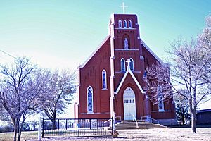
St. Bridget Church (2020)
|
|

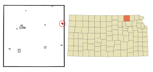
Location within Marshall County and Kansas
|
|

|
|
| Country | United States |
| State | Kansas |
| County | Marshall |
| Founded | 1860s |
| Platted | 1872 |
| Incorporated | 1887 |
| Named for | Jesse Axtell |
| Area | |
| • Total | 0.53 sq mi (1.37 km2) |
| • Land | 0.52 sq mi (1.36 km2) |
| • Water | 0.00 sq mi (0.01 km2) |
| Elevation | 1,348 ft (411 m) |
| Population
(2020)
|
|
| • Total | 399 |
| • Density | 753/sq mi (291.2/km2) |
| Time zone | UTC-6 (CST) |
| • Summer (DST) | UTC-5 (CDT) |
| ZIP code |
66403
|
| Area code | 785 |
| FIPS code | 20-03600 |
| GNIS ID | 2394045 |
Axtell is a small city in Marshall County, Kansas, United States. In 2020, about 399 people lived there. It is a quiet place with an interesting history.
Contents
History of Axtell
The first people settled in the Axtell area in the 1860s. The first post office in Axtell opened in December 1871. The city was officially planned in 1872. This happened when the railroad line was built to that spot. A train station was also built that year. The city was named after Jesse Axtell, who worked for the railroad.
Geography of Axtell
Axtell covers a total area of about 0.51 square miles (1.32 square kilometers). All of this area is land.
Weather in Axtell
Axtell has a type of weather called a "humid continental climate." This means the area has big changes in temperature throughout the year. Summers are warm to hot and often humid. Winters are cold, and sometimes very cold.
People in Axtell (Demographics)
| Historical population | |||
|---|---|---|---|
| Census | Pop. | %± | |
| 1880 | 255 | — | |
| 1890 | 643 | 152.2% | |
| 1900 | 651 | 1.2% | |
| 1910 | 748 | 14.9% | |
| 1920 | 617 | −17.5% | |
| 1930 | 607 | −1.6% | |
| 1940 | 545 | −10.2% | |
| 1950 | 510 | −6.4% | |
| 1960 | 493 | −3.3% | |
| 1970 | 456 | −7.5% | |
| 1980 | 470 | 3.1% | |
| 1990 | 432 | −8.1% | |
| 2000 | 445 | 3.0% | |
| 2010 | 406 | −8.8% | |
| 2020 | 399 | −1.7% | |
| U.S. Decennial Census | |||
Axtell's Population in 2020
The 2020 United States census counted 399 people living in Axtell. There were 172 households and 98 families. The city had about 763 people per square mile. Most of the people (about 91%) were white. About 2% of the population was Hispanic or Latino.
About a quarter of the households had children under 18. Nearly half of the households were married couples. About 37% of households were single people living alone. The average household had 2.7 people. The average family had 3.4 people.
The median age in Axtell was 38.1 years. This means half the people were younger and half were older than 38.1. About 29% of the population was under 18 years old. About 18.5% were 65 years or older.
Axtell's Population in 2010
The census of 2010 counted 406 people in Axtell. There were 178 households and 111 families. The population density was about 796 people per square mile. Most people (96.8%) were white.
About a quarter of the households had children under 18. More than half of the households were married couples living together. About 33% of all households were made up of individuals. About 16% of households had someone living alone who was 65 or older.
The median age in the city was 43 years. About 25% of residents were under 18. About 23% were 65 or older. For every 100 females, there were about 107 males.
Education in Axtell
The public schools in Axtell are part of the Prairie Hills USD 113 school district. This district was created in 2010. It was formed when two smaller school districts, Sabetha USD 441 and Axtel USD 488, joined together.
See also
 In Spanish: Axtell (Kansas) para niños

