
Babyshoe Pass facts for kids
Quick facts for kids Babyshoe Pass |
|
|---|---|

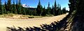
The graveled section of Forest Route 23 traverses Babyshoe Pass, in the Midway High Lakes Area on the northwest side of Mount Adams.
|
|
| Elevation | 4,350 ft (1,326 m) |
| Traversed by | U.S. Forest Route 23 |
| Location | Skamania County, Washington, U.S. |
| Range | Cascades |
| Coordinates | Mapper 46°16′05″N 121°36′17″W / 46.26802°N 121.6046°W |
Babyshoe Pass is a high mountain pass located in the Gifford Pinchot National Forest. It sits on the northwest side of Mount Adams in the state of Washington. This pass is an important connection point for many trails and areas.
Forest Route 23 goes right through Babyshoe Pass. This road helps people travel north and south on the east side of the Gifford Pinchot National Forest. It also leads to popular spots like the Mount Adams Wilderness and the Midway High Lakes Area.
Where is Babyshoe Pass?
Babyshoe Pass is found at an elevation of about 4,350 feet (1,326 meters). It is along Primary Forest Route 23. This route connects with Primary Forest Route 90 and Primary Forest Route 21.
Exploring the Midway High Lakes Area
The pass is located in the beautiful Midway High Lakes Area. This area is known for its five high-elevation lakes. These lakes are all within a seven-mile circle. The most well-known lake here is Takhlakh Lake.
A stream that flows through Babyshoe Pass is also the source of Babyshoe Falls.
Images for kids
-
A panoramic view of Babyshoe Pass along Forest Route 23.
