
Midway High Lakes Area facts for kids
Quick facts for kids Takhlakh Lake |
|
|---|---|

Mount Adams seen from picturesque Takhlakh Lake
|
|

Takhlakh Lake
Location in Washington (state)

Takhlakh Lake
Location in the United States
|
|
| Location | Skamania County, Washington, United States |
| Coordinates | 46°16′39″N 121°35′46″W / 46.277445°N 121.595993°W |
| Type | natural |
| Primary inflows | unnamed inflow creeks |
| Primary outflows | Canyon Creek (Tributary) |
| Catchment area | 0.70295 sq mi (1.8206 km2) |
| Basin countries | United States |
| Max. length | 1,788 ft (545 m) |
| Max. width | 1,129 ft (344 m) |
| Surface area | 33 acres (13 ha) |
| Surface elevation | 4,390 ft (1,340 m) |
| Islands | 0 |
| Settlements | (none) |
The Midway High Lakes Area, also known as the High Lakes Area, is a special place managed by the United States Forest Service. You can find it in Washington’s Cascade Mountains. This beautiful area sits on a high plateau on the northwest side of Mount Adams.
It's located between the Goat Rocks to the north and Mount Hood to the south. The area is home to Takhlakh Lake and several other pretty lakes. There are five main high-elevation lakes, all within a seven-mile circle. The Gifford Pinchot National Forest takes care of this region. While other mountains like St. Helens or Rainier get more visitors, the High Lakes Area is one of the most popular spots around Mount Adams. Many of the lakes offer amazing views of Mount Adams reflected in their clear waters.
Contents
Exploring the High Lakes Area


The Midway High Lakes Area is found below the huge volcanic peak of Mount Adams, which is 12,276 feet (3,742 m) tall. The Adams Glacier tumbles down from the summit in icy sections. This glacier is the second largest in Washington, after the Carbon Glacier on Mount Rainier.
The area has many cool volcanic features besides Mount Adams. These include the Takh Takh Lava Flow, the Muddy Fork Lava Flows, and Potato Hill. Potato Hill is a small cinder cone, like a mini-volcano, about 200 feet tall. You'll also find lovely meadows and marshy areas here. Takh Takh Meadows is a well-known spot, and Muddy Meadows is another, close to the Riley Horse Camp. From Muddy Meadows, you can get onto the Pacific Crest Trail and explore the Mount Adams Wilderness.
Discover the Major Lakes
The Midway High Lakes Area is famous for its beautiful lakes. Here are the five main ones:
| Lake Name | Size | Height Above Sea Level | |
|---|---|---|---|
| 1 | Takhlakh Lake | 33 acres (13 ha) | 4,390 ft (1,340 m) |
| 2 | Olallie Lake | 15.8 acres (6.4 ha) | 4,242 ft (1,293 m) |
| 3 | Council Lake | 43.7 acres (17.7 ha) | 4,221 ft (1,287 m) |
| 4 | Horseshoe Lake | 25 acres (10 ha) | 4,140 ft (1,260 m) |
| 5 | Chain of Lakes | (12 small lakes) ~26.3 acres (10.6 ha) | ~4,395 ft (1,340 m) |
| 6 | Green Mountain Lake | 2.5 acres (1.0 ha) | 4,042 ft (1,232 m) |
Fun Activities and Recreation

The High Lakes Area is a fantastic place for outdoor adventures! You can go hiking on many trails or try backpacking for longer trips. The lakes are perfect for fishing, non-motorized boating, and canoeing. You can also enjoy scenic drives through the area.
There are many places to stay, from developed campgrounds to more basic camping spots. Popular campgrounds include Takhlakh Lake Campground, Olallie Lake Campground, and Horseshoe Lake Campground. Other options are Killen Creek Campground, Council Lake Campground, Chain of Lakes Campground, Cat Creek Campground, Twin Falls Campground, and Adams Fork Campground. Walupt Lake Campground is also nearby, just northeast of the High Lakes Area.

The High Lakes Area is a highlight of the 79-mile High Lakes Loop. This is a scenic driving route that starts in Randle and is part of the White Pass National Scenic Byway.
You can also find several beautiful waterfalls nearby, such as Twin Falls, Steamboat Falls, Babyshoe Falls, Big Spring Creek Falls, and Riley Creek Falls.
Featured in Media
The beauty of Takhlakh Lake and the surrounding area has been recognized by National Geographic several times:
- In 1989, National Geographic featured a photo of people enjoying Takhlakh Lake.
- In 2013, National Geographic showcased a stunning photo titled "Mount Adams reflected in Takhlakh Lake." This picture was part of their "Ultimate Adventure Bucket List 2013," which highlighted twenty must-do trips around the world. The article suggested a 35-mile hike around Mount Adams, using trails like the Highline and Round the Mountain, and even some off-trail sections.
Images for kids
-
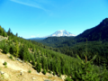
Mount Adams from East Canyon Ridge
-
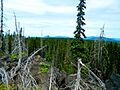
A view from the Takh Takh Lava Flow
-
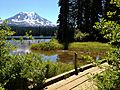
Bridge at Takhlakh Lake
-
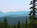
A view of the Goat Rocks from the trail in the Takh Takh Lava Flow


