
Bacchus Marsh, Victoria facts for kids
Quick facts for kids Bacchus MarshVictoria |
|||||||||||||||
|---|---|---|---|---|---|---|---|---|---|---|---|---|---|---|---|

Main St, Bacchus Marsh
|
|||||||||||||||

Bacchus Marsh
Location in Shire of Moorabool
|
|||||||||||||||
| Population |
|
||||||||||||||
| • Density | 103.642/km2 (268.43/sq mi) | ||||||||||||||
| Postcode(s) | 3340 | ||||||||||||||
| Elevation | 118 m (387 ft) | ||||||||||||||
| Area | 196.3 km2 (75.8 sq mi) | ||||||||||||||
| Location | |||||||||||||||
| LGA(s) | Shire of Moorabool | ||||||||||||||
| State electorate(s) | Melton | ||||||||||||||
| Federal Division(s) | Ballarat | ||||||||||||||
|
|||||||||||||||
Bacchus Marsh is a lively town in Victoria, Australia. It is located about 50 kilometers (31 miles) north-west of Melbourne, which is the capital city of Victoria. In 2016, about 20,345 people lived in Bacchus Marsh. This makes it the biggest town in the Shire of Moorabool, which is like its local government area.
The town is famous for its fresh fruit and vegetable farms. In more recent times, many people who live in Bacchus Marsh travel to Melbourne for work. This means it has become a "commuter town." Bacchus Marsh got its name from one of its first settlers, Captain William Henry Bacchus. The town is nestled between two important rivers: the Lerderderg and the Werribee.
Contents
Exploring Bacchus Marsh
Bacchus Marsh offers a mix of history, nature, and community life. It's a great place to learn about how towns grow and change over time.
The Story Behind the Name
Bacchus Marsh was named after Captain William Henry Bacchus. He was one of the first European settlers to arrive in the area. He settled here in the early 1800s. His arrival helped shape the beginnings of the town we know today.
Rivers and Nature
The town is lucky to have two rivers flowing nearby. The Lerderderg River and the Werribee River are important parts of the local environment. These rivers provide water for the farms and create beautiful natural areas. People can enjoy activities like walking and exploring along their banks.
Lerderderg River
The Lerderderg River flows through a stunning gorge. This area is known as the Lerderderg State Park. It's a popular spot for hiking and enjoying the bushland. The river's path has carved out impressive landscapes over many years.
Werribee River
The Werribee River also plays a big role in the region. It supports local wildlife and plants. Both rivers are vital for the health of the surrounding environment. They also help the farms in the area grow their produce.
Farming and Food
Bacchus Marsh is well-known for its rich farming land. For many years, it has been a key area for growing fruit and vegetables. The fertile soil and river access make it perfect for agriculture.
Local Produce
You can often find fresh local produce from Bacchus Marsh. This includes delicious strawberries, apples, and other seasonal fruits. The town's farming heritage is a big part of its identity. It helps provide fresh food for many people.
Life in a Commuter Town
In recent years, Bacchus Marsh has grown a lot. Many people choose to live here and travel to Melbourne for work. This is what makes it a "commuter town."
Why People Choose Bacchus Marsh
People like living in Bacchus Marsh for many reasons. It offers a quieter lifestyle than a big city. It still has good connections to Melbourne for jobs and entertainment. This balance makes it an attractive place for families.
Community and Activities
Bacchus Marsh has a strong community spirit. There are many local clubs and activities for young people. These include sports teams and community events.
Sports and Recreation
Sports are a big part of life in Bacchus Marsh. Teams like the local Australian Rules Football club play at places like Darley Park. There are also facilities for other sports and outdoor activities.
Avenue of Honour
One special landmark is the Bacchus Marsh Avenue of Honour. This is a beautiful road lined with Elm trees. It forms the main entrance to the town center from the east. It is a place of remembrance and beauty.
Getting Around
Bacchus Marsh is connected by road and rail. The Bacchus Marsh railway station helps people travel to and from the town. This makes it easy for commuters and visitors.
Images for kids
-
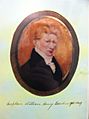
Captain William Bacchus, image from display in Bacchus Marsh Library, 2015.
-
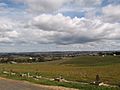
The urban area as viewed from its rural-urban fringe.
-
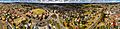
Aerial perspective of Bacchus Marsh. Taken Autumn 2018
-
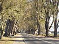
The Bacchus Marsh Avenue of Honour, an Elm tree lined avenue forms the main entrance to the CBD from the east.
-
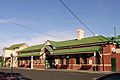
Bacchus Marsh railway station in Maddingley
-

Lerderderg River
-
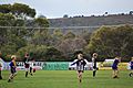
Junior Australian Rules Football at Darley Park (BFL League)


