Bahía de Caráquez facts for kids
Quick facts for kids
Bahía de Caráquez
|
|
|---|---|
|
City
|
|
| La Villa de San Antonio de Caráquez | |
 |
|
| Country | Ecuador |
| Province | Manabí |
| Canton | Sucre Canton |
| Founded | March 1624 |
| Founded by | José de Larrazábal |
| Area | |
| • City | 15.07 km2 (5.82 sq mi) |
| Population
(2022 census)
|
|
| • City | 22,209 |
| • Density | 1,473.7/km2 (3,816.9/sq mi) |
| Time zone | UTC−5 (ECT) |
| Climate | BSh |
| Website | www.bahiadecaraquez.com |
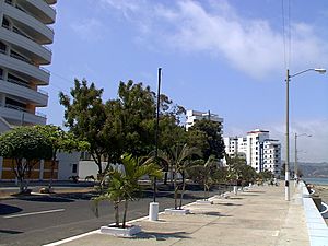
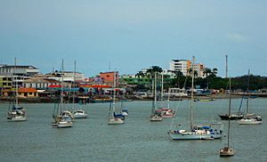
Bahía de Caráquez, often called Bahía, is a city on the coast of Ecuador. It is part of the Sucre county in the Manabí Province. The city sits on a sandy piece of land where the Río Chone meets the ocean.
Bahía is a popular place for tourists. Over the past 15-20 years, it has grown a lot. Many people from Quito and Guayaquil come here for vacations. The city is about an hour north of Manta. Long ago, an ancient city called Caran was here. Across the bay from Bahía is the town of San Vicente.
Bahía became an Ecocity on February 23, 1999. This happened after two big natural disasters in 1997 and 1998 caused a lot of damage.
You can cross the Rio Chone to San Vicente by bridge or boat. The bridge was finished in November 2010. Bahía is a popular spot for visitors and has a different feel from San Vicente.
The city also has a famous archeological museum. It shows old items found in Manabí. These items come from different times in history. The collection includes statues from the Valdivia culture and other ancient groups.
Contents
History of Bahía de Caráquez
Early History and Founding
The city of Bahía de Caráquez was officially founded in March 1628. Its full name was Villa de San Antonio de la Bahía de Caráquez. José de Larrazábal founded it under the rule of Philip IV of Spain. This was ordered by Doctor Antonio de Morga, who was the President of the Royal Audience of Quito.
Trade in the Colonial Era
From the late 1500s to the mid-1600s, Bahía was an important trade route. It connected places like Panama and Quito. It was a key link between ports in South America and Central America.
However, in 1629, leaders in Los Reyes (Peru) changed things. They decided to favor the port of Santiago de Guayaquil. This made Guayaquil the main trading center. They even stopped other European ships from trading freely at Indian ports. This was done to control silver and food supplies for Spain.
People of Bahía
Bahía de Caráquez has about 22,209 people. Most of them are mestizos, which means they have mixed European and Indigenous heritage. There are also many people of Spanish descent. In the early 1900s, many families from Italy and Lebanon moved here. Their descendants still live in the city today. Because it's on the coast, Bahía is a major tourist spot in Manabí.
What Bahía Does for Money
Bahía is great for tourism, but its main business is raising shrimp. In the bay, there are about 6,000 hectares of pools where shrimp are grown. The local industry is still growing. There is one factory that processes and exports frozen shrimp. There is also an ice factory and a purified water factory.
In the countryside near Leónidas Plaza, people raise cattle and pigs. There are also about a dozen chicken farms that produce eggs.
Getting Around Bahía
You can reach Bahía de Caráquez by road from Quito and Guayaquil. In San Vicente, there is an airport with a paved runway. This airport is 1900 meters long. There is also a road that connects to the Esmeraldas province.
On November 3, 2010, the "Los Caras" bridge opened. This bridge links San Vicente with Bahía. It also completed the Spondylus Route, a famous coastal highway.
Climate in Bahía
Bahía de Caráquez has a warm, semi-arid climate. This means it is generally hot and dry. The average temperature is around 27-30 degrees Celsius. The city gets most of its rain from January to April. The rest of the year is much drier.
| Climate data for Bahía de Caráquez, elevation 3 m (9.8 ft), (1971–2000) | |||||||||||||
|---|---|---|---|---|---|---|---|---|---|---|---|---|---|
| Month | Jan | Feb | Mar | Apr | May | Jun | Jul | Aug | Sep | Oct | Nov | Dec | Year |
| Mean daily maximum °C (°F) | 28.7 (83.7) |
29.6 (85.3) |
30.0 (86.0) |
30.1 (86.2) |
28.7 (83.7) |
27.2 (81.0) |
26.5 (79.7) |
26.1 (79.0) |
26.1 (79.0) |
26.4 (79.5) |
26.7 (80.1) |
27.5 (81.5) |
27.8 (82.1) |
| Mean daily minimum °C (°F) | 22.9 (73.2) |
23.2 (73.8) |
23.2 (73.8) |
23.2 (73.8) |
22.9 (73.2) |
21.8 (71.2) |
21.3 (70.3) |
21.0 (69.8) |
21.1 (70.0) |
21.4 (70.5) |
21.4 (70.5) |
22.3 (72.1) |
22.1 (71.9) |
| Average precipitation mm (inches) | 94.0 (3.70) |
160.0 (6.30) |
149.0 (5.87) |
60.0 (2.36) |
24.0 (0.94) |
12.0 (0.47) |
4.0 (0.16) |
3.0 (0.12) |
4.0 (0.16) |
5.0 (0.20) |
3.0 (0.12) |
12.0 (0.47) |
530 (20.87) |
| Average relative humidity (%) | 80 | 82 | 83 | 81 | 82 | 84 | 84 | 84 | 83 | 82 | 82 | 80 | 82 |
| Source: FAO | |||||||||||||
Images for kids
See also
 In Spanish: Bahía de Caráquez para niños
 | Emma Amos |
 | Edward Mitchell Bannister |
 | Larry D. Alexander |
 | Ernie Barnes |


