Bally, Pennsylvania facts for kids
Quick facts for kids
Bally, Pennsylvania
|
|
|---|---|
|
Borough
|
|

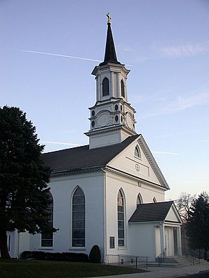
Most Blessed Sacrament Church in Bally, Pennsylvania
|
|

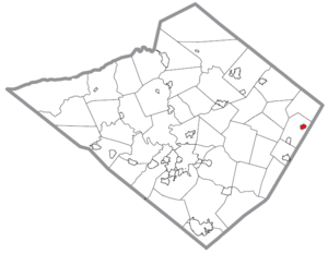
Location of Bally in Berks County, Pennsylvania
|
|
| Country | United States |
| State | Pennsylvania |
| County | Berks |
| School District | Boyertown |
| Incorporated | 1912 |
| Area | |
| • Total | 0.51 sq mi (1.33 km2) |
| • Land | 0.51 sq mi (1.33 km2) |
| • Water | 0.00 sq mi (0.00 km2) |
| Elevation | 259 ft (79 m) |
| Population
(2020)
|
|
| • Total | 1,228 |
| • Density | 2,393.76/sq mi (924.36/km2) |
| Time zone | UTC-5 (EST) |
| • Summer (DST) | UTC-4 (EDT) |
| ZIP Code |
19503
|
| Area code(s) | 610 |
| FIPS code | 42-03984 |
Bally is a small town, called a borough, located in Berks County, Pennsylvania, in the United States. In 2020, about 1,228 people lived there. It's known for its interesting history and some important businesses.
Contents
History of Bally
Bally was first known as Goshenhoppen. This name might have come from a Native American word meaning "meeting place." Another idea is that German settlers called the area their "haven" (Hafen in German), which eventually became Goshenhoppen. Mennonite and Catholic families started settling here in the early 1700s.
In 1731, a religious leader named Ulrich Beidler built the first church for the Mennonite community. Later, in 1741, a Jesuit priest named Father Theodore Schneider arrived. He started one of the first Catholic mission churches in the original 13 colonies. On land given by the Mennonites, Father Schneider built St. Paul's Chapel in 1743. Today, this church is called the Most Blessed Sacrament Church. It is the oldest Catholic church building still standing in Pennsylvania.
Father Schneider also started a Catholic school in 1743. This school, first named St. Aloysius Academy, was the beginning of Catholic education in the 13 colonies. After changing its name a few times, it is now known as St. Francis Academy. It is the oldest Catholic school in the country that teaches both boys and girls.
Because the town had many churches, Goshenhoppen was later renamed Churchville. In 1883, when a post office was opened, the town changed its name again to Bally. This new name honored Father Augustine Bally, a Catholic pastor who had passed away the year before. Bally officially became a borough in 1912. Henry Eddinger was chosen as its first leader, called a Burgess.
Many Pennsylvania Dutch settlers and their families have traditionally made Bally their home.
In 1912, a missionary named Annie Funk from Bally was on her way home from India to visit her sick mother. She was on the RMS Titanic when it sank. It is said that Annie Funk bravely gave up her seat in a lifeboat to another passenger.
Bally's Economy
Bally has many businesses and industries, and some are known around the world. Some of the biggest companies in Bally include Bally Refrigerated Boxes, Bally Ribbon Mills, and Gold Toe Socks. There are also many farms in the area.
Bally is in the middle of a region called Butter Valley. This area stretches from Hereford to Boyertown. The name "Butter Valley" comes from the large number of dairy farms in the valley.
A famous artist and designer named Harry Bertoia also lived in the Bally area. He had his art studio on Main Street in Bally.
Geography of Bally
Bally is located at 40°24′4″N 75°35′18″W / 40.40111°N 75.58833°W. It covers about 0.5 square miles (1.3 square kilometers) of land. The town is completely surrounded by Washington Township.
Population and People
| Historical population | |||
|---|---|---|---|
| Census | Pop. | %± | |
| 1920 | 387 | — | |
| 1930 | 579 | 49.6% | |
| 1940 | 613 | 5.9% | |
| 1950 | 753 | 22.8% | |
| 1960 | 1,033 | 37.2% | |
| 1970 | 1,197 | 15.9% | |
| 1980 | 1,051 | −12.2% | |
| 1990 | 973 | −7.4% | |
| 2000 | 1,062 | 9.1% | |
| 2010 | 1,090 | 2.6% | |
| 2020 | 1,228 | 12.7% | |
| Sources: | |||
In 2010, Bally had a population of 1,090 people. The average age of people living there was about 41.9 years old. By 2020, the population had grown to 1,228.
In 2000, there were 1,062 people living in Bally. About 28.8% of the homes had children under 18. The average home had about 2.57 people living in it.
Education in Bally
Students in Bally attend schools within the Boyertown Area School District.
Public Services
Bally has several important public services to help its residents. These include the Eastern Berks Fire Department, the Bally Community Ambulance, and the Bally Police Department. These groups work to keep the community safe.
Transportation
As of 2006, Bally had about 5.67 miles of public roads. Some of these roads are kept up by the Pennsylvania Department of Transportation (PennDOT), and others are maintained by the borough itself.
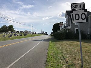
Pennsylvania Route 100 is the main highway that goes through Bally. It runs along Main Street, passing through the center of the town.
See also
 In Spanish: Bally (Pensilvania) para niños


