
Bangor International Airport facts for kids
Quick facts for kids
Bangor International Airport
|
|||||||||||
|---|---|---|---|---|---|---|---|---|---|---|---|
| Summary | |||||||||||
| Airport type | Public | ||||||||||
| Owner/Operator | City of Bangor | ||||||||||
| Serves | Bangor, Maine | ||||||||||
| Elevation AMSL | 192 ft / 59 m | ||||||||||
| Coordinates | 44°48′26″N 068°49′41″W / 44.80722°N 68.82806°W | ||||||||||
| Website | www.flybangor.com | ||||||||||
| Runway | |||||||||||
|
|||||||||||

Bangor International Airport (BGR) is a public airport for passengers. It is located about 3 miles (5 km) west of the city of Bangor, Maine, in the United States. The City of Bangor owns and runs this airport.
This airport was once a military base. It was known as Dow Air Force Base. Today, it has one very long runway. This runway is 11,439 feet (3,486 meters) long and 200 feet (60 meters) wide.
Contents
Why is Bangor International Airport Important?
Bangor International Airport is used a lot by planes. This is because it is close to the Great Circle Route. This route is a major air path. It connects Europe and the East Coast of the United States.
The word 'international' in the airport's name is important. It does not mean it has regular flights to nearby Canada. Instead, it refers to its role in flights that cross the Atlantic Ocean. Many planes flying between continents stop here.
Airlines and Flights
Bangor International Airport offers passenger flights. Three main airlines serve the airport. These airlines help people travel to different places.
The airlines that fly from Bangor are:
- Delta Airlines
- Allegiant Air
- US Airways
Images for kids
-
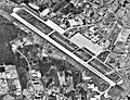
Aerial view of Bangor International Airport

See also
 In Spanish: Aeropuerto Internacional de Bangor para niños
