Baoruco Mountain Range facts for kids
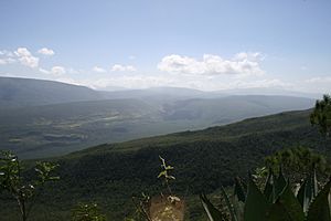
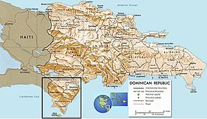
The Bahoruco Mountain Range—also called the Sierra de Bahoruco—is a chain of mountains located in the far southwestern part of the Dominican Republic. You can find it across the Pedernales, Independencia, Barahona, and Bahoruco Provinces. A big part of this area is protected as the Sierra de Bahoruco National Park, which is also a special Biosphere reserve.
The name "Bahoruco" was first written down by Bartolomé de las Casas. He heard it from the Taino Indians, who were the first people living in that region.
These mountains are rich in natural resources like salt and gypsum. There's also a lagoon called Oviedo Lagoon in the southern part. Between this mountain range and the Neiba mountain range is Lake Enriquillo, which is the largest lake in the Antilles islands.
How the Mountains Formed
The Bahoruco Mountain Range is like a huge block of land that was formed from volcanoes a very long time ago. This was during the Cretaceous period, which was about 145 to 66 million years ago. After the volcanoes, the whole mountain range was covered by the sea. This means that at one point, these mountains were underwater!
Later, the land rose up out of the sea. This happened because of a big collision between the Caribbean and Atlantic plates, which are like giant puzzle pieces that make up Earth's surface. Because of this, you can find rocks high up in the mountains, even over 2,000 meters high, that still show signs of ancient corals that once lived in the sea.
Larimar: A Special Blue Stone
The Sierra de Bahoruco is famous for a beautiful blue stone called larimar. This unique blue color comes from how the stone formed inside the volcanic rocks of the mountains.
Larimar is a special type of mineral. It's known as pectolite, which is a mineral made of calcium and sodium silicates. It's a really unique gem found mostly in this area!
See also
 In Spanish: Sierra de Bahoruco para niños
 | Toni Morrison |
 | Barack Obama |
 | Martin Luther King Jr. |
 | Ralph Bunche |


