Barhapple Loch facts for kids
Quick facts for kids Barhapple Loch |
|
|---|---|

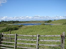
View of Barhapple Loch from Derskelpin Farm in the southwest.
|
|
| Location | Derskelpin, Glen Luce, Wigtonshire |
| Coordinates | 54°53′48″N 4°42′54″W / 54.8967°N 4.7150°W |
| Type | freshwater loch |
| River sources | Dergoals Burn |
| Surface area | 9.6 ha (24 acres) |
| Average depth | 2.6 ft (0.79 m) |
| Max. depth | 3 ft (0.91 m) |
| Shore length1 | 1.2 km (0.75 mi) |
| Surface elevation | 88 m (289 ft) |
| 1 Shore length is not a well-defined measure. | |
Barhapple Loch is a small freshwater loch (which means lake) located in Wigtownshire, Dumfries and Galloway in Scotland. It's shaped a bit like a semicircle. Barhapple Loch is most famous for an exciting discovery made in 1878: an ancient island home called a Crannog. This discovery happened when the loch was drained.
Contents
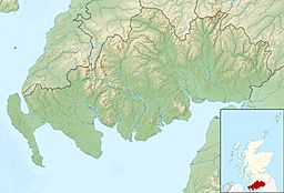
Where is Barhapple Loch?
Barhapple Loch is about 4 miles (6.5 km) east of a town called Glenluce. It's a "kettle hole" loch, which means it formed when a large block of ice from a glacier melted a long time ago.
Nearby, to the south, you'll find Derskelpin Farm. Just a little east of the farm is another loch called Dernaglar Loch. To the southwest, there's Dirlaughlin Hill (114 meters high) and Knock Moss. To the east, you can see Barhapple Hill (107 meters high) and Mark of Luce Moss.
Nearby Towns
Glenluce is the biggest town close to the loch. It's about 3.9 miles southwest of Barhapple Loch. Another town, Newton Stewart, is about 10 miles northeast, along the A75 road.
Discovering an Ancient Island Home (Crannog)
Barhapple Loch is quite shallow, only a few feet deep. Most of its edges are surrounded by a deep peat bog, which is like a very wet, spongy area made of decayed plants. The east side is different, as it touches Barhapple Hill and has firmer ground.
The water in the loch is dark, and the west shore was hard to reach. This made it difficult to find any hidden ancient homes. However, in 1842, a man named James McCulloch was cutting peat about 40 yards from the west side of the loch. He found a circle of about 12 wooden stakes. These stakes were made of Hazel wood and were about 5 feet long. Their tops were two feet below the ground. The circle was about 5 feet wide.
Then, in the autumn of 1878, the loch was drained. In November, the farmer living nearby noticed a small, round area of logs that had become visible. This was the first clear sign of the crannog.
Exploring the Crannog
On October 15, 1880, a group of people, led by John Dalrymple, Earl of Stair, went to explore the crannog. Sir John Dalrymple-Hay, 3rd Baronet was also part of this group of eight. They started digging, but water quickly filled the hole at about two to three feet deep. Even so, they made several important discoveries.
They found that the ancient island home was mostly made of oak wood piles and a wooden platform. There were also some rough stones. The crannog was located about 280 feet from the shore. To help people see it, a long wooden walkway, or gangway, was built from the east shore. This walkway was 550 feet long and started from the firm ground at the foot of Barhapple Hill.
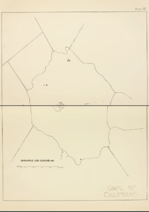
The main part of the crannog was a row of oak piles. These piles enclosed an area that was 175 feet long (north to south) and 127 feet wide. The corners of this area were rounded. Sir Herbert Maxwell took the first measurements of what was left of the crannog. He counted 134 visible piles. There were small gaps on the west side and a larger one on the south side, where the piles were not set closely together. It seemed the crannog was connected to the north and east shores of the loch by gangways built on piles. During the digging, a ring made of Cannel coal, about 5.68 cm wide, was also found.
In 1884, more digging was done. Some of the logs had rotted away, and marsh plants had grown through others. This happened because the area was only partly drained.
Modern Surveys of the Crannog
In July 2002, the crannog was surveyed again as part of the South-West Scotland Crannog Survey. The goal was to find a way to check how quickly the old wood was decaying. Many of the timbers felt soft and spongy. Because the loch is shallow and its water levels change, the wood is unlikely to last forever. Experts recommended ongoing checks of the site.
It's thought that about 3,000 trees were used to build this crannog! The names of places near Barhapple often include "der," "dir," and "dar." This suggests that the area was once heavily covered with trees.
A traditional rhyme, passed down through generations, was told to archaeologist Robert Munro by a local farmer. It goes:
- Knocketie and Knockietore, Laniegoose and Laniegore, Dirnefuel and Dirniefranie, wee Barsolas and Derrnagie
Underwater surveys were also done in 2003 and 2004 as part of the same survey. It's interesting to know that Barhapple Loch isn't the only one in the Old Luce parish with a crannog; there are four other lochs in the area that also have these ancient island homes.
Plants and Wildlife
The north side of Barhapple Loch is covered by a thick growth of a plant called Phragmites Communis, which is a type of reed. On the west side, there's a lot of marshy ground. This area is mostly covered by plants like Carex rostrata and C. filiformis, which are types of sedges.
The east shore is gravelly and peaty. On the south side, you can find plants such as Juncus bufonius (toad rush), Juncus supinus, and Peplis portula. There aren't many mosses or liverworts (small, simple plants) growing on the shores.
 | William Lucy |
 | Charles Hayes |
 | Cleveland Robinson |


