Barneston, Nebraska facts for kids
Quick facts for kids
Barneston, Nebraska
|
|
|---|---|
|
Village
|
|
 |
|

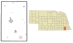
Location of Barneston, Nebraska
|
|
| Country | United States |
| State | Nebraska |
| County | Gage |
| Area | |
| • Total | 0.24 sq mi (0.64 km2) |
| • Land | 0.24 sq mi (0.63 km2) |
| • Water | 0.00 sq mi (0.00 km2) |
| Elevation | 1,207 ft (368 m) |
| Population
(2020)
|
|
| • Total | 90 |
| • Density | 368.85/sq mi (142.20/km2) |
| Time zone | UTC-6 (Central (CST)) |
| • Summer (DST) | UTC-5 (CDT) |
| ZIP code |
68309
|
| Area code(s) | 402 |
| FIPS code | 31-03075 |
| GNIS feature ID | 2398033 |
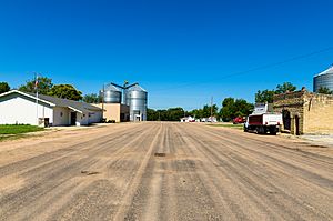
Barneston is a small village in Gage County, Nebraska, in the United States. In 2020, about 90 people lived there.
Contents
A Look at Barneston's Past
Barneston was built where a large Oto Native American village once stood. In the 1800s, this was an important spot. It had a trading post and an agency for the Oto people.
A French fur trapper, who was married to an Oto woman, founded Barneston. The town was officially planned in 1884. This happened when the Marysville and Blue Valley Railroad reached the area. The village was named after Francis M. Barnes, one of the first settlers.
Where is Barneston?
Barneston is a small place. According to the United States Census Bureau, it covers about 0.24 square miles (0.63 square kilometers). All of this area is land.
Barneston's Weather
Barneston has a varied climate. It gets snow in winter and rain throughout the year. May and June are usually the wettest months.
| Climate data for Barneston, Nebraska (coordinates:40°02′56″N 96°34′29″W / 40.0489°N 96.5747°W, 1991-2020) | |||||||||||||
|---|---|---|---|---|---|---|---|---|---|---|---|---|---|
| Month | Jan | Feb | Mar | Apr | May | Jun | Jul | Aug | Sep | Oct | Nov | Dec | Year |
| Average precipitation inches (mm) | 0.52 (13) |
0.90 (23) |
2.22 (56) |
2.96 (75) |
5.16 (131) |
4.97 (126) |
4.36 (111) |
3.46 (88) |
3.30 (84) |
2.46 (62) |
1.43 (36) |
0.71 (18) |
32.45 (823) |
| Average snowfall inches (cm) | 4.6 (12) |
3.1 (7.9) |
2.1 (5.3) |
1.3 (3.3) |
0.0 (0.0) |
0.0 (0.0) |
0.0 (0.0) |
0.0 (0.0) |
0.0 (0.0) |
0.4 (1.0) |
0.7 (1.8) |
3.3 (8.4) |
15.5 (39.7) |
| Average precipitation days (≥ 0.01 in) | 3.4 | 2.9 | 5.2 | 7.2 | 8.2 | 6.7 | 7.1 | 5.8 | 5.4 | 4.6 | 4.5 | 2.4 | 63.4 |
| Average snowy days (≥ 0.01 in) | 2.7 | 1.4 | 0.7 | 0.2 | 0 | 0 | 0 | 0 | 0 | 0.1 | 0.7 | 1.5 | 7.3 |
| Source: NOAA | |||||||||||||
Who Lives in Barneston?
The number of people living in Barneston has changed over the years. Here's how the population has looked:
| Historical population | |||
|---|---|---|---|
| Census | Pop. | %± | |
| 1900 | 250 | — | |
| 1910 | 228 | −8.8% | |
| 1920 | 258 | 13.2% | |
| 1930 | 221 | −14.3% | |
| 1940 | 219 | −0.9% | |
| 1950 | 208 | −5.0% | |
| 1960 | 177 | −14.9% | |
| 1970 | 149 | −15.8% | |
| 1980 | 155 | 4.0% | |
| 1990 | 122 | −21.3% | |
| 2000 | 122 | 0.0% | |
| 2010 | 116 | −4.9% | |
| 2020 | 90 | −22.4% | |
| U.S. Decennial Census | |||
Barneston in 2010
In 2010, there were 116 people living in Barneston. These people lived in 48 different homes. Most people were White (93.1%). About 8.6% of the population was Hispanic or Latino.
- Many homes (45.8%) had married couples living together.
- Some homes (22.9%) had children under 18.
- About 14.6% of homes had someone living alone who was 65 or older.
The average age of people in Barneston was 45 years old. About 20.7% of residents were under 18. Slightly more than half (52.6%) of the residents were female.
See also

- In Spanish: Barneston (Nebraska) for kids
 | Selma Burke |
 | Pauline Powell Burns |
 | Frederick J. Brown |
 | Robert Blackburn |

