Barnum Island, New York facts for kids
Quick facts for kids
Barnum Island, New York
|
|
|---|---|
 |
|

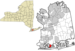
Location in Nassau County and the state of New York.
|
|
| Country | |
| State | |
| County | |
| Town | Hempstead |
| Area | |
| • Total | 1.24 sq mi (3.21 km2) |
| • Land | 0.86 sq mi (2.24 km2) |
| • Water | 0.37 sq mi (0.97 km2) |
| Elevation | 0 ft (0 m) |
| Population
(2020)
|
|
| • Total | 2,590 |
| • Density | 2,994.22/sq mi (1,155.44/km2) |
| Time zone | UTC-5 (EST) |
| • Summer (DST) | UTC-4 (EDT) |
| ZIP code |
11558
|
| Area code(s) | 516 |
| FIPS code | 36-04550 |
| GNIS feature ID | 1867393 |

Barnum Island is a small community in Nassau County, New York. It is called a hamlet and a census-designated place (CDP). In 2020, about 2,590 people lived there.
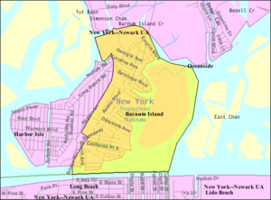
Barnum Island is part of a larger island located between Long Island and Long Beach. This larger island used to be known as Hog Island. Today, it includes Barnum Island and Island Park. Barnum Island is managed by the Town of Hempstead.
The LIRR train tracks separate most of Barnum Island from the Village of Island Park. Even though it's separate, Barnum Island shares services with Island Park. For example, the Island Park School District serves kids from Barnum Island. They also share the same ZIP code, which is 11558.
Contents
History of Barnum Island
How Barnum Island Got Its Name
Barnum Island was first called Hog Island. This name came from wild pigs that early European explorers brought to the area. Later, the island was renamed after a woman named Sarah Ann Baldwin Barnum. Some people mistakenly think it was named after P.T. Barnum, the famous circus owner, but that's not true.
The "Poor Farm" Idea
In the mid-1800s, Sarah Ann Barnum's husband, Peter, owned a lot of land on Long Island. Sarah Ann bought Hog Island to create a "poor farm." This was a special kind of almshouse, which was a place where poor people could live and work to support themselves. This idea was quite new for its time.
Changes Over the Years
Around 1898, the county stopped using the island as a poor farm. They sold it to a company called Jekyl Island Realty Company. The company renamed the island Jekyl Island. Over the next few years, the island was sold several times to different developers.
Some canals were built on the island during this time. One of these canals now separates the Harbor Isle section from Island Park. In 1921, new developers bought the island. They started building many homes in the Island Park section, which became a popular summer resort by 1925. Island Park officially became a village in 1926.
The rest of the island stayed unincorporated. The western part became known as Harbor Island. The eastern part kept the name Barnum Island. All three parts – Barnum Island, Island Park, and Harbor Island – were once part of the original Hog Island.
Hurricane Sandy's Impact
In 2012, Hurricane Sandy caused a lot of flooding on the entire island. The water was between two and eight feet deep in some places.
Geography and Location
Barnum Island is located at 40°36′19″N 73°38′51″W / 40.60528°N 73.64750°W. It covers about 1.3 square miles (3.21 square kilometers). Most of this area, about 0.9 square miles (2.24 square kilometers), is land. The rest, about 0.4 square miles (0.97 square kilometers), is water.
Population Facts
| Historical population | |||
|---|---|---|---|
| Census | Pop. | %± | |
| 2020 | 2,590 | — | |
| U.S. Decennial Census | |||
In 2020, there were 2,590 people living in Barnum Island. The average age of people living there was 47 years old. About 18% of the population was under 18 years old.
Nunley's Ferris Wheel
Barnum Island is home to a famous Ferris wheel from the old Nunley's Amusement Park. This park used to be located near Baldwin and Freeport, New York. After the park closed in 1995, many of its rides were sold.
Nassau County bought Nunley's Carousel, another popular ride, and moved it to the Cradle of Aviation Museum in Garden City. The Ferris wheel, however, ended up in Barnum Island.
See also
 In Spanish: Barnum Island para niños


