
Barony and Castle of Giffen facts for kids
Quick facts for kids Giffen Castle |
|
|---|---|
| Barrmill, North Ayrshire, Scotland UK grid reference NS377507 |
|

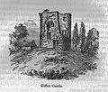
Giffen castle in 1835 with the buildings of Mains of Giffen visible to the right-hand side
|
|

Giffen Castle
|
|
| Coordinates | 55°43′22″N 4°35′06″W / 55.7229°N 4.5849°W |
| Height | 40ft |
| Site information | |
| Owner | Giffen Mains Farm |
| Controlled by | Montgomery clan |
| Open to the public |
Private |
| Condition | No clear remains |
| Site history | |
| Built | 15th century |
| In use | Until 18th century |
| Materials | stone |
The Barony of Giffen was a large area of land in North Ayrshire, Scotland. It included a 15th-century castle called Giffen Castle. The name can be spelled Giffen or Giffin. This area was part of a bigger region called the Lordship of Giffin. It covered about half of the parish of Beith.
Giffen has a long history. It had a special hill called a moot hill or justice hill where important decisions were made. There was also a mill where people had to grind their grain. A 'gathering place' called the 'Borestone' was also important. An old chapel and a holy well were also part of the area. Most of these old features are gone today.
Contents
What Does Giffen Mean?
The name Giffen comes from an old language called Brittonic. It might mean "ridge," like a hill, or "a common/shared boundary."
The Story of Giffen Castle
Giffen Castle was a tall tower, about 40-foot-high (12 m). It stood on a 180-foot-high (55 m) ridge of rock. Experts think it was built in the 15th century. However, there might have been an older building there as early as the 13th century.
In the 1700s, the castle was bought by Sir John Anstruther. He let the castle fall into ruin. A sundial from the castle garden was moved to another house.
In 1726, a local miller was allowed to take stones from the castle. He used them to build a house at the mill. The castle's roof was removed, leaving the inside open to the weather.
Local farmhouses were also built using stones from the castle. The front wall of the castle was completely taken down. Above the main entrance, there was a carving of a man shooting a crossbow at a wild boar. This might have been a story about a brave hunter from the Giffen family.
For some years after the roof was gone, young people would climb the stairs. They would light fires there on the eve of a special saint's day.
In 1837, the south wall of the castle fell. Then, on April 12, 1838, the rest of the castle walls collapsed. This left only a pile of stones. The nearby Mains of Giffen farm was also built with stones from the castle.
In 1956, only three small pieces of the castle walls remained. The rest was taken down around 1920 when a quarry was dug nearby. By 1983, there were no castle remains left standing. Some large blocks of stone were used in a garden rockery.
In the 1890s, a farmer found many bones when digging near the castle. People believed these were from a battle fought by the castle's lord. Metal detectors later found musket balls in this area.
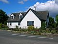
Giffen House: A New Mansion


In 1855, William Patrick bought the lands of Giffen. His grandnephew, Henry Gardiner Patrick, built a large and beautiful mansion. This house was in the Scottish Baronial style. It was built in 1861, about 2 miles (3.2 km) from the old Giffen Castle.
Giffen House was designed in 1869 by John Murray Robertson. It is now a 'B Listed' building, meaning it's historically important.
The house was very big, with 35 rooms. It had living rooms, bedrooms, nurseries, and servant's rooms. It also had stables, a garage, and a coachman's house. The estate was about 885 acres. The owner died in 1922, and the estate was sold.
The Hamlet of Giffen
Old maps from the 1700s show a small village or hamlet next to Giffen Castle. It was called 'Giffin'.
Old Chapels and the Chapel Well
There were chapels and wells near Giffen Castle. One chapel was near the castle, next to a well still marked on maps today. Another chapel was at Trearne, dedicated to St. Bridget. It had a burial ground. The ruins of the Trearne chapel were destroyed by quarrying. Workers found bodies buried face down there.
In the 12th century, land was given to monasteries for chapels. This led to some confusion. It seems there were three chapels in the Giffen area at one time, not just two.
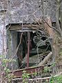
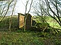
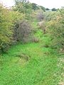
- Giffen Castle and mill - 2007
-
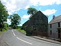
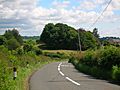
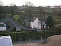
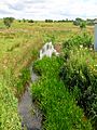
The Giffen mill complex and Giffen brae; the road to Mains of Giffen and Burnhouse
-
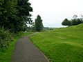
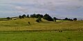
The woodland denotes the site of old Giffen castle. See the 1860s print above as a comparison.
-
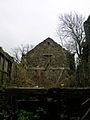
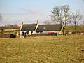
Mains of Giffen, partly built with stones from Giffen castle
-
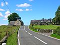
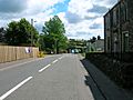
Mains of Giffen with the site of the old 'castletoun' to the left, and the road to Barrmill from Burnhouse


The Lords of Giffen

In the 13th century, Walter de Mulcaster received the lands of Giffen. Later, the lands were given to Alexander de Nenham. Alexander gave land to a monastery for a chapel.
The De Morville family supported John Baliol, who lost the Scottish crown to Robert the Bruce. So, Giffen went back to the crown. In 1370, Sir Hugh de Eglinton was given the Lordship. Giffen then stayed with the Montgomerie family for many centuries.
Sir Robert Montgomerie was the first Montgomerie of Giffen around 1400. Many sons inherited the land. In 1560, Patrick Montgomerie helped establish the Protestant faith in Scotland. He was later sent away for a time because of his beliefs.
The Montgomerie family line for Giffen eventually ended. The barony went back to the main Eglinton branch of the family.

One Montgomerie, Sir Henry Montgomerie of Giffen, was called "Graysteel" because he was very good with a sword.
Francis Montgomerie, a later lord, was an important person in government. He helped with the Treaty of Union in 1706, which joined Scotland and England. This treaty was not popular with everyone.
John Montgomerie, Francis's son, became the Governor of New York in 1727. He died there in 1731. He had to sell his estates, and Giffen was bought by Sir John Anstruther in 1722. This meant the Montgomerie line of Giffen ended.

The Montgomerie of Giffen family had their own coat of arms. It showed symbols of both the Montgomeries and the Eglintons.
There was once a loch called Loch Brand. In 1482, monks had to take legal action against the Montgomeries of Giffen Castle. They were accused of damaging the loch's walls.
The Giffen Baron-Court
The Giffen Baron-court was a local court. Robert Montgomerie of Giffen was a Baron-Baillie, like a judge, for this court in the late 1600s.
The Giffen Coat of Arms


This coat of arms was originally in the old Beith Kirk (church). It was moved to the new Beith Kirk in 1807. The letters "RC" stand for Robert Montgomerie. "JC" is for Jean Campbell, his wife. The letters "MEs" mean 'Master of Eglintoun'.
The Darien Scheme
The Darien Scheme was a Scottish plan in the 1690s to set up a trading colony in Central America. It failed badly and caused huge financial losses for Scotland. Many people lost a lot of money. For example, Francis Montgomerie of Giffen lost £1000. This was a massive amount of money back then. The Act of Union later provided some compensation for these losses.
Giffen Mill

The old Giffen Mill, also known as Barmill, is still partly visible today. The remains are from the early 1800s. It was likely rebuilt on an older site. An outside staircase led to the kiln, where corn was dried before grinding. The miller's house, built in the mid-1700s, is still lived in.
Old maps show Giffen Mill with other buildings nearby. The mill pond and water channel (lade) are clearly marked on maps from 1858. By 1923, the mill was no longer marked. Before it closed, the mill machinery was used to power a saw mill.
Giffen Mill was a "thirled" mill. This meant that people living on the Giffen lands had to bring their grain to this mill to be ground. They also had to help repair the mill and bring new millstones. These millstones sometimes came from far away.
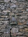
As mentioned before, the miller's house had two carved stones from Giffen Castle. The mill itself had another carved stone, an 'Eagle', which is still there today.
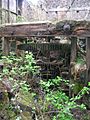
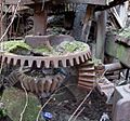
- Details of Giffen Mill - 2007
-
The remains of the waterwheel inside the mill extension
-
Inside the mill looking towards Greenhill
-
The main mill machinery
-
The adaptations to drive the saw mill.


-
The 'Eagle' from Giffen Castle, now in the lower gable wall of Giffen mill
-
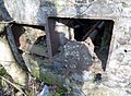
The external saw mill machinery remnants.
-
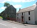
Giffen mill and Miller's house. The doorway is said to have come from the old castle.
-
Giffen Mill and the old Miller's house from the village of Barrmill
-
The Dusk Water which powered Giffen Mill


Greenhills Hamlet


This small village is shown on old maps from the 1700s. It had a school that opened in the 1890s and closed around 1958. The school building was later used as a glue factory and was torn down in the 1980s. A blacksmith's shop used to be at the crossroads. The hamlet is named after a special mound called a Moot or Justice hill.
The Moot or Justice Hill
This artificial mound was where the Giffen Castle Baronial Court announced its decisions. For serious crimes, people were punished here. This right was called 'pit and gallows'. Many other places had similar hills. The 'Green hill' was near Greenhill farm. No sign of this mound remains today.
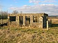
Borestone Farm and the Bore Stane

In 1876, a large sandstone called the Bore Stone was recorded. It had a circular hole. People said the flagstaff of the barony was put here when people were called to battle. This spot would have been visible from all over the area. However, it was probably just a natural hole in the rock. The Bore Stone was broken up around 1950. During World War II, soldiers training in the area used it.
Bank of Giffen


In 1858, a farm called 'Bank of Giffen' stood near the old railway line. It was abandoned by 1911. Some ruins of the farm can still be seen today. A secret tunnel is said to run from Bank of Giffen to Giffen Castle. Some children supposedly found it and went through it safely years ago.
Nettlehirst House and Estate
Nettlehirst was a grand house, like a castle. It overlooked the old Giffen Station. The Burns family built Nettlehirst House in 1844. In July 1932, the house burned down, possibly from an electrical fire. The fire was so big it could be seen from a train carrying children returning from a Sunday School trip.
The house was never rebuilt and was torn down. However, some parts of the estate still remain. These include the unique entrance gateposts, an orchard, boundary walls, a family burial place (mausoleum), the farm, and the stables. The stables have an 1811 marriage stone.
The family burial ground is still there, but the crypt has been broken into. No names are visible on the structure.
-
Nettlehirst's old groom's cottage and stables.
-
Nettlehirst old estate wall and trees.
-
A ruin within the Nettlehirst grounds bearing an 1811 marriage stone.
-
A side entrance
-
The back of the mausoleum
-
The frontage


The name Nettlehirst might come from "Nettle," the plant, and "Hurst," meaning a harvest or a barren hill. This describes the area well today.
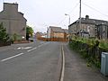
Barrmill Village


An old map from the 1700s only shows High Barr farm. A village grew here because of jobs in limestone quarries and other local industries.
The village had about 300 people in 1876 and 600 in 1951. At that time, a thread-making factory had just closed. The limestone works also closed in 1972. Quarries for whinstone employed many people, but they were almost empty by 1951. An old coal pit near Bankhead Moss closed around 1897. A quoiting ground (for a game) was in what is now the park. In 2006, new houses were built where the old Barrmill railway station used to be.
Local Railways

The Giffenmill Viaduct, a large bridge, opened in 1903. It was no longer used by 1950 and was taken down in 2006. It was also called the Barr Mill or Dusk Water viaduct. The nearby Gree Viaduct was also demolished in 2008.
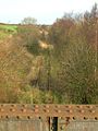
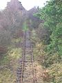
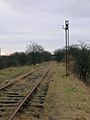
The local train station, originally called Kilbirnie Junction, opened in 1888. It was renamed Giffen in 1889. Giffen station closed in 1932. It had three platforms and several staff members. The platforms are still there today, but the railway line is no longer used.
Barrmill railway station served Barrmill village. It opened in 1873 and closed to passengers in 1962. Freight trains continued until 1964. An old map from 1897 shows a tramway running from quarries to Barrmill station.
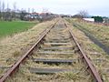
- Views of Giffen station (2008)
-
Looking towards Barrmill from the Giffen overbridge
-
Giffen railway station from the overbridge
-

Giffen station looking towards Barrmill
-
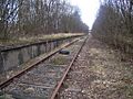
The Old Kilbirnie Junction station, later Giffen station in 2006


-
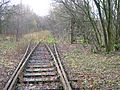
Pointwork and an old security gate
-
An old blast wall next to the station
-
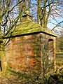
Workmen's hut near the blast wall
-
Old sign for munitions traffic operations


Giffen Limeworks
Giffen Limeworks started in the mid- to late 1800s. They were probably the last traditional limeworks in Scotland, closing in 1972. A lot of the kilns were still standing in 2009, but they have been slowly taken down since then.
Limekilns


Limekilns are common on farms in this area. They were used to burn limestone, which was dug from nearby quarries. This produced lime, which was very useful. Farmers spread it on fields to make the soil better. It was also used in building mortar and for painting farm buildings.
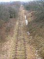
- Views of Giffen, Greenhills, and Barrmill (2007)
-
The old school site at Greenhills
-
The line and old signal running towards Giffen station
-
The old railway line running towards Lugton at Barmill
-
old line near Tandlehill Farm
-
The course of the old 'Hillhead Railway' from Barkip Junction to Broadstone limestone quarry
-
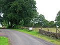
The Giffin House main entrance, near Auchenmade


-
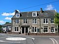
The Old Station Inn in Barrmill
-
Barrmill crossroads, with hotel and shop
-
Barrmill's Community Hall
-
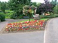
Barrmill's millennium garden
-
Barrmill's mainstreet with the railway bridge, looking towards Greenhills
-
Barrmill's park


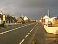
Burnhouse (The Trap)
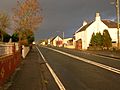
This small village is known locally as 'The Trap'. It's short for 'Man Trap'. The village is on an old road where travelers used to stop at the inn. Farmers' wives called it 'The Trap' because people would spend all their money there.
An old map from 1828 shows a Crossroads Inn. In 1858, there were two inns: the Burnhouse Inn and the Waggoners Inn. What is now the Burnhouse Manor hotel was a private house in 1858. A toll house, where people paid to use the road, used to be nearby but has been torn down.
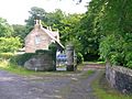
- Burnhouse Manor and 'The Trap' village (2008)
-
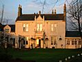
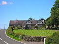
The Burnhouse Manor Hotel
-
Burnhouse village looking towards Lugton
-
Another view looking towards Lugton


More from Old Maps
The 1858 map spells the name 'Giffen'. It shows a small quarry near Burnhouse. This quarry grew over the years and eventually destroyed the site of Giffen Castle. The castle ruins are clearly marked in 1858, but not on later maps.
Drumbuie House
Drumbuie House, built in 1702, is one of the oldest homes in the Beith area. It has been home to the Boyd family for many years. Drumbuie was part of the Barony of Giffen. An old mill, Drumbuie mill, was nearby on the Dusk Water, but no remains are left.
Mossend Farm


Mossend Farm might have been a small mansion once. By the 1920s, only ruins remained. A quarry was located to the east of the house. The last people to live there were George and Ellen Black. George made curling stones, possibly using stone from the nearby quarry.
Local Stories and History


In 1837, a year before Giffen Castle fell, a directory described it as "...the stately ruined castle of the Montgomeries."
In 1958, a small collection of 16th-century coins was found near Mains of Giffen. They were hidden in a bronze box. The coins were Scottish, dating from 1558 to 1574. They were probably hidden in the late 1570s.

The Dusk Water, which powered Giffen Mill, flows into the River Garnock. The interesting Cleeves Cove cave system is downstream of Giffen.
In the 1830s, about 40 local people died from cholera. They were buried in a triangular plot near Jamesill Hill. People say the disease came from a group of travelers.
William Patrick of Roughwood hired a builder to construct the 'Barnweil Monument' near Ayr in memory of William Wallace.
Mossend Farm is now ruins in a small group of trees, next to a quarry.
Images for kids
-
Giffen castle in the 1800s with what is probably the old Giffen Farm, just visible to the left-hand side
-
The Giffen Craigs and Bank of Giffen from Burnhouse Manor Farm.
-
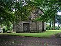
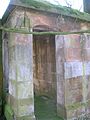
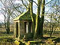
The old Giffen aisle at Beith Auld Kirk
-
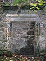
The blocked up Giffen Aisle doorway
-
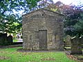
The old church end of the aisle


