
Barrio Azteca Historic District facts for kids
Quick facts for kids |
|
|
Barrio Azteca Historic District
|
|

Spanish Colonial House on Zaragoza Street
|
|

Barrio Azteca Historic District
Location in Texas

Barrio Azteca Historic District
Location in the United States
|
|
| Location | Roughly bounded by I-35, Matamoros St., Arroyo Zacate, and the Rio Grande, Laredo, Texas |
|---|---|
| Area | 120 acres (49 ha) |
| Architectural style | Mission, Spanish Revival |
| NRHP reference No. | 03000431 |
| Added to NRHP | May 21, 2003 |
El Azteca is a really old and special neighborhood in Laredo, Texas. Many of its buildings are from the 1870s! It shows off different building styles that have been popular in the border area for a long time.

Contents
Where is El Azteca?
El Azteca is a neighborhood located east of Downtown Laredo. It's bordered by Interstate 35, Matamoros Street (which is part of U.S. Highway 83), Zacate Creek, and the Rio Grande.
A Look at El Azteca's Past

The first people to live in El Azteca were descendants of Spanish colonists. They started settling along the lower Rio Grande in the mid-1700s. Later, many immigrants from Mexico moved here. They helped build the community and worked on the new international railroad that arrived in 1881.
By the early 1900s, El Azteca was a busy neighborhood. It had many homes and small businesses. Most of the people living there were of Mexican or Mexican-American heritage.
The Famous El Azteca Theater
The neighborhood got its name from the El Azteca Theatre. This theater first opened in 1922 as the Teatro Nacional. It was a place where people could watch plays and vaudeville shows. Vaudeville was a type of entertainment with different acts like music, comedy, and dance.
In the 1930s, movies became very popular. So, the theater changed its name to El Azteca movie house. It started showing movies in Spanish. Another theater nearby, the Iturbide Theater, was known as the "Home of Spanish Vaudeville." Many important people of Mexican origin also moved to this neighborhood to escape the Mexican Revolution.
Why El Azteca is Special
El Azteca was named a National Register Historic District in 2003. This means it's recognized as an important historical place. It's special because of its location, how it's laid out, and its natural features.
Amazing Location and Natural Borders
The neighborhood sits on a high cliff overlooking the Rio Grande. This river forms its southern edge and is also the border between the United States and Mexico.
Zacate Creek defines the eastern border of El Azteca. This creek has steep walls. Long ago, it provided fresh water for the people and animals living there. Zacate Creek was also the site of the Battle of Laredo in 1865. This was one of the last battles of the Civil War.
Connecting the City
The first electric streetcar line built west of the Mississippi River passed through El Azteca. It crossed Zacate Creek using the Iturbide Street Bridge. This bridge and the streetcar helped connect the neighborhood and the city of Laredo. They linked El Azteca to new shopping and living areas that were growing east of the creek.
In the late 1970s, Interstate 35 was built. This highway cut El Azteca off from the very old center of Laredo. However, the neighborhood has still kept much of its historic charm. It has many old buildings, some of which are rare and unique. These buildings show the special architecture found only in the borderlands of South Texas.
Images for kids
-
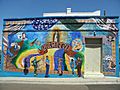
Mural on 20 Iturbide Street Building.
-
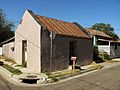
Sandstone building, one of the oldest structures in the neighborhood.


