Zacate Creek facts for kids
Quick facts for kids Zacate Creek |
|
|---|---|

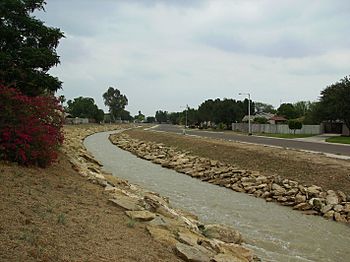
A northern branch of Zacate Creek
|
|
| Physical characteristics | |
| Main source | Laredo, Texas 423 ft (130 m) |
| River mouth | Rio Grande at Laredo, Texas 352 ft (110 m) |
| Length | 10 mi (16 km) |
Zacate Creek is a stream located entirely within the city of Laredo, Texas. It flows for about 10 miles (16 kilometers) in a southwest direction. Finally, it connects with the Rio Grande, a major river that forms part of the border between the United States and Mexico.
Many smaller streams and ditches feed into Zacate Creek. The land around the creek is mostly made of clay. You can find plants like mesquite trees, different types of cacti, and various grasses growing there.
Zacate Creek and its smaller branches cross several important roads in Laredo. These include Interstate 35, United States Route 59, Texas State Highway Spur 400, Texas State Highway 359, and United States Route 83. A small dam on the northern part of Zacate Creek creates a pond. This pond is usually full of water after storms. The city of Laredo has also created the Zacate Creek Park and the Zacate Creek Greenway. This greenway is a three-mile trail located near the creek, perfect for walking or biking.
The Battle of Laredo
During the American Civil War, which happened from 1861 to 1865, Laredo, Texas, was a very important place. It was a main route for the Confederate States to send cotton to Mexico. This cotton was then sold to help fund their war efforts.
On March 18, 1864, a group of about 200 Union Army soldiers arrived in Laredo. They were led by Major Alfred Holt. Their mission was to destroy 5,000 large bundles of cotton. These bundles were stored at the San Agustín Plaza in the city.
However, a Confederate officer named Colonel Santos Benavides was there with only 42 men. Despite being greatly outnumbered, Colonel Benavides and his soldiers bravely defended the cotton. They fought off three attacks from the Union soldiers right at Zacate Creek. This important event is now known as the Battle of Laredo.
 | May Edward Chinn |
 | Rebecca Cole |
 | Alexa Canady |
 | Dorothy Lavinia Brown |

