Battle of Cape Gloucester facts for kids
Quick facts for kids Battle of Cape Gloucester |
|||||||
|---|---|---|---|---|---|---|---|
| Part of the Pacific War of World War II | |||||||
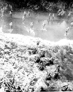 US Marines hit three feet of rough water as they leave their LST to take the beach at Cape Gloucester, New Britain, 26 December 1943. |
|||||||
|
|||||||
| Belligerents | |||||||
| Commanders and leaders | |||||||
| Units involved | |||||||
|
1st Marine Division
|
65th Brigade
|
||||||
| Casualties and losses | |||||||
| 310 killed 1,083 wounded |
2,000 killed | ||||||
The Battle of Cape Gloucester was a fight during World War II. It happened in the Pacific War between Japan and the Allied forces. The battle took place on the island of New Britain, which is part of New Guinea. It lasted from December 26, 1943, to January 16, 1944.
This operation was called "Operation Backhander." It was part of a bigger Allied plan called "Operation Cartwheel." The main goal was to take over two Japanese airfields near Cape Gloucester. These airfields were important for controlling the skies. The US 1st Marine Division led the attack. This was their second major landing of the war.
On December 26, 1943, US Marines landed on both sides of the Cape Gloucester peninsula. One group landed on the west side to distract the Japanese. They also cut a main road. The main force landed on the east side. They moved north towards the airfields. The land was very swampy, which made it hard to move. A Japanese counterattack slowed them down for a short time. But by the end of December, the Marines had captured the airfields.
Fighting continued into January 1944. The Marines pushed their control further south. The main fighting ended on January 16, 1944, when they captured a key spot called Hill 660. However, smaller clean-up operations lasted until April 1944. After that, US Army troops took over from the Marines.
Contents
Why the Battle of Cape Gloucester Was Fought
Understanding the Location: Cape Gloucester's Geography
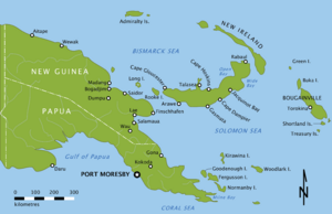
Cape Gloucester is a piece of land at the western end of New Britain island. New Britain is northeast of mainland New Guinea. It is separated from New Guinea by the Vitiaz and Dampier Straits. In 1943, this area was called the Territory of New Guinea.
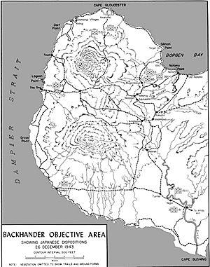
The cape is about 230 miles west of Rabaul. Rabaul was a major Japanese base. The land itself has a curved coastline. There are tall, extinct volcanoes nearby, like Mount Talawe. The area is covered in thick rainforest and swamps. In 1943, there were only a few beaches good for landing troops. There were no proper roads along the coast.
The weather was hot and humid. It rained a lot, especially during the monsoon season. This heavy rain affected when the battle could happen. Before the war, there was a landing strip at Cape Gloucester. After Japan took over New Britain in 1942, they built two airstrips there. The Allies knew the area was hard for big ships. But small boats could use the coast. Borgen Bay was used by the Japanese to move supplies by barge.
The Bigger Picture: Why the Allies Attacked New Britain
By late 1943, the Allies were winning in New Guinea. They had stopped the Japanese push towards Port Moresby. They also forced the Japanese to leave Guadalcanal. The Allies then started "Operation Cartwheel." This plan aimed to weaken the big Japanese base at Rabaul. It also aimed to cut off Japanese supply lines. The Allies wanted to move towards the Philippines next.
On September 22, 1943, General Douglas MacArthur ordered the invasion of New Britain. This was called "Operation Dexterity." The plan was to take control of the western part of New Britain. "Operation Backhander" was the part of this plan focused on Cape Gloucester. Its goal was to capture and improve the two Japanese airfields. This would help to isolate Rabaul. It would also make sure Allied ships could pass safely through the straits.
Some Allied leaders debated if invading New Britain was needed. The US air commander, General George Kenney, thought it would take too long to build up the airfields. He believed the Allies would move past them too quickly. But army and navy leaders felt it was important to protect supply routes. The Japanese thought the Allies would try to capture Rabaul directly. So, they kept many troops there. This meant fewer troops were available to defend western New Britain.
Getting Ready for Battle
Who Fought: American Marines vs. Japanese Troops
The job of taking western New Britain went to Lieutenant General Walter Krueger's Alamo Force. For Cape Gloucester, the US assigned the 1st Marine Division. This division was led by Major General William H. Rupertus. They had fought before on Guadalcanal.
The original plan included an airborne landing by paratroopers. But this was later canceled due to concerns about weather and space. So, more troops were added to the sea landing. The main attack force came from the 7th Marine Regiment and the 1st Marine Regiment. The 5th Marine Regiment was kept as a reserve. Artillery support came from the 11th Marine Regiment.
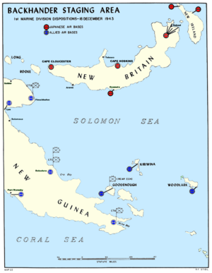
In mid-1943, parts of the 1st Marine Division were in Australia. They practiced landings there. Then they moved to New Guinea. More practice landings happened in December 1943. The troops gathered at Cape Sudest before the battle.
The US troops faced parts of the Japanese 17th Division. These troops were led by Major General Iwao Matsuda. They were called "Matsuda Force." They included the 65th Brigade and other units. Before the battle, there were almost 4,000 Japanese troops near Cape Gloucester. Their strength was weakened by sickness and lack of supplies. Japanese supply boats were often attacked by the Allies.
Preparing the Battlefield
The landing at Cape Gloucester was set for December 26. Before this, the Allies built up a month's worth of supplies at Oro Bay. On December 25, the US Army's 112th Cavalry Regiment landed at Arawe. This was a diversion to draw Japanese troops away from Cape Gloucester. It worked, pulling about 1,000 Japanese soldiers away.
For months, Allied planes bombed the area around the airfields. They used planes from the US Fifth Air Force. Japanese defenses were destroyed. The airfields were put out of action by November. Allied planes flew many missions, dropping tons of bombs. They also bombed Japanese airfields at Rabaul and Kavieng to keep Japanese planes busy. Allied scouts and coastwatchers also secretly landed to gather information.
The Japanese focused on defending the airfield. They built bunkers and trenches along the coast. The strongest defenses were to the southeast. They also had a strong position at the base of Mount Talawe. This spot overlooked the airfields. The beaches to the east were mostly left undefended because they were surrounded by swamps. The Japanese planned to defend key hills and control important paths.
The Battle Begins
The Journey to Cape Gloucester
The Allied plan was to land troops on both sides of the peninsula. Then, they would advance north to the airfields. The troops boarded their ships on Christmas Day. The convoy, called Task Force 76, had many different types of landing ships. These included large LSTs for heavy vehicles and smaller LCIs for troops. Twelve destroyers protected the convoy.
The ships carried troops, bulldozers, tanks, and trucks. They also carried enough food and ammunition for a long fight. To unload quickly, supplies were preloaded onto 500 trucks. These trucks would drive straight off the LSTs onto the beach. Medical teams were also ready to help the wounded.
The convoy was spotted by a Japanese plane. The Japanese commander thought the ships were going to Arawe as reinforcements. So, he sent a large air attack there instead of Cape Gloucester. This was a mistake that helped the Allies.
Landing on the Beaches
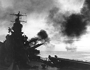
The main attack started at dawn on December 26. US Navy ships fired their guns at Japanese positions. Then, US and Australian planes bombed the area. Many squadrons of bombers and attack planes provided close air support. Fighter planes flew patrols to protect the ships from Japanese aircraft.
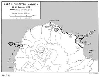
The 1st Marine Division landed at Yellow Beaches 1 and 2 on the east side. This was about 5 miles southeast of the airfield. A smaller group landed at Green Beach on the west side. This was a diversion. The main assault was on the east.
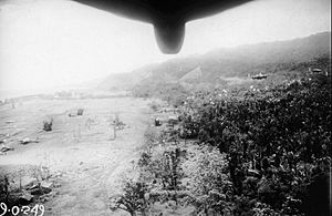
The western landing at Tauali (Green Beach) faced no resistance. The Japanese defenses there were empty. The Marines quickly secured the beachhead. They cut the coastal road, stopping Japanese movement. However, the Japanese had another hidden route.
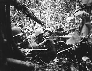
Soon after the western landing, the Japanese sent troops to respond. The Marines fought small groups of Japanese. On December 30, two Japanese companies attacked the Marines at "Coffin Corner." A five-hour battle followed. The Marines pushed back the attack. After this, there were no more major attacks on the western side. Patrols continued, and the western force later joined the main US troops.
Pushing Towards the Airfields
The main force landed on the eastern side. The 7th Marine Regiment secured the beach. Then, the 1st Marine Regiment pushed through them. They began to advance north towards the airfields. The 5th Marine Regiment stayed in reserve.
Before the landing, Navy ships and planes heavily bombed the beaches and Target Hill. The first wave of Marines landed with no opposition. However, a small group landed in the wrong spot and came under machine gun fire. The landing area was very swampy. This made it hard for the Marines and their tanks to move. It also caused a lot of traffic on the beaches, slowing down unloading.
Japanese planes attacked the Allied ships in the afternoon. One US destroyer, the USS Brownson, was sunk. Other ships were damaged. But US fighters and anti-aircraft guns shot down many Japanese planes. By the end of the first day, about 13,000 troops and 7,600 tons of equipment were ashore. The Japanese launched a quick counterattack, but it was pushed back.
The next day, the Marines moved west. They reached a Japanese blocking position called Hell's Point. This position was well hidden with anti-tank guns. Engineers worked to improve the roads. But heavy rain made the narrow coastal road muddy. This made it hard to move supplies and evacuate the wounded. On December 28, a new landing beach, Blue Beach, was set up closer to the fighting. The Marines attacked Hell's Point with tanks. Many Japanese were killed.
On December 29, the 5th Marine Regiment landed. They made a flanking move to the southwest. The 1st Marine Regiment continued along the coast. By the end of the day, the Marines had broken through Japanese defenses. They controlled most of the airfield. Bad weather stopped Japanese air attacks. The Marines expanded their control around the airfield. In early January, they linked up with the western landing force.
Securing Borgen Bay
After capturing the airfield, US troops pushed south towards Borgen Bay. They wanted to move beyond the range of Japanese artillery. The 5th Marine Regiment and 7th Marine Regiment fought against the remaining Japanese troops. These Japanese soldiers had marched north from Cape Bushing.
On January 6, US troops secured Aogiri Ridge and Hill 150. Then, they moved towards Hill 660. Bad weather, rough land, and Japanese resistance made progress slow. After three days of fighting, Hill 660 was finally captured on January 16, 1944. This marked the end of major Japanese defense in the area. The Japanese commander, Matsuda, pulled back with about 1,100 troops.
Building Up the Base
After the battle, engineers started working on the airfields. They found the Japanese airfields were in bad shape. They decided to focus on one airfield, No. 2. Heavy rain and blackout rules made work difficult. They had to remove a lot of grass and dirt. They used volcanic ash to make the ground stable. Steel mats were laid on top to create a runway.
By January 31, 1944, 4,000 feet of runway were ready. By March 18, a 5,200-foot runway was complete. They also built alert areas, parking spots for planes, a control tower, and roads. Transport planes started landing in January. Fighter squadrons moved in by February and March. The Australian Air Force also moved squadrons to Cape Gloucester. They provided air support for the Marines and protected convoys.
To support air operations, they built large fuel storage tanks. A pier was built for supply ships. They also built storage areas, warehouses, and a 500-bed hospital. A water supply system was installed. They built 35 miles of all-weather roads using local materials. A sawmill produced lumber from local timber.
What Happened Next
After Cape Gloucester, US and Australian forces also landed on Long Island. They set up a radar station there. In mid-January, the Japanese commander, Yasushi Sakai, asked to pull his troops out of western New Britain. US patrols from Cape Gloucester and Arawe met up in February. Marines also checked Rooke Island to make sure it was clear of Japanese troops.
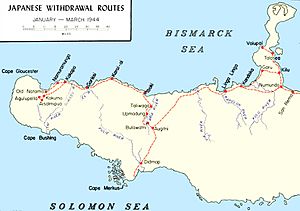
Japanese forces began to move away from western New Britain in late February. Marine patrols kept up the pressure. They fought several small battles in the center of the island. In early March 1944, the Americans launched an operation to capture Talasea. This was part of the Japanese withdrawal towards Rabaul.
The 1st Marine Division left Cape Gloucester on April 23, 1944. The US Army's 40th Infantry Division took over. The fighting on New Britain slowed down. The US focused on the western end of the island. They decided not to attack Rabaul directly. The Japanese stayed near Rabaul. Later, Australian forces took over operations on New Britain. In November 1944, they launched a limited attack to keep the Japanese confined to the Gazelle Peninsula. The Japanese stayed there until the war ended.
 | Chris Smalls |
 | Fred Hampton |
 | Ralph Abernathy |


