New Britain facts for kids
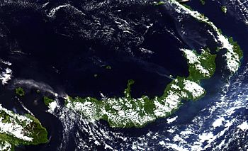
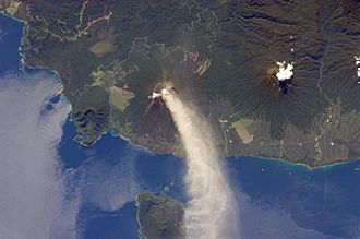
New Britain from space, June 2005. Clearly visible are ash plumes from Langila and Ulawun volcanoes
|
|
| Geography | |
|---|---|
| Coordinates | 5°45′S 150°36′E / 5.750°S 150.600°E |
| Archipelago | Bismarck Archipelago |
| Area | 35,144.6 km2 (13,569.4 sq mi) |
| Area rank | 38th |
| Length | 520 km (323 mi) |
| Width | 146 km (90.7 mi) |
| Highest elevation | 2,500 m (8,200 ft) |
| Highest point | Mount Ulawun |
| Administration | |
| Provinces | West New Britain, East New Britain |
| Demographics | |
| Population | 513,926 (2011) |
| Pop. density | 14.07 /km2 (36.44 /sq mi) |
| Ethnic groups | Papuans and Austronesians |
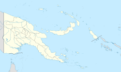
New Britain (called Niu Briten in Tok Pisin) is the biggest island in the Bismarck Archipelago. This group of islands is part of Papua New Guinea.
New Britain is separated from the large island of New Guinea by a part of the Solomon Sea. It is also separated from New Ireland by St. George's Channel. The main towns on New Britain are Rabaul/Kokopo and Kimbe. The island is about the same size as Taiwan.
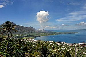
Long ago, when the island was part of German New Guinea, it was called Neupommern, which means "New Pomerania". Like many islands in the Bismarck Archipelago, New Britain was mostly formed by volcanoes. It still has active volcanoes today. These include Ulawun (the tallest volcano in Papua New Guinea), Langila, the Garbuna Group, and the Sulu Range. The volcanoes Tavurvur and Vulcan are part of the Rabaul caldera.
In 1994, a huge eruption from Tavurvur volcano destroyed Rabaul. Rabaul was the capital city of East New Britain province. Most of the town is still buried under thick ash. Because of this, the capital was moved to a nearby town called Kokopo.
Contents
Exploring New Britain's Geography
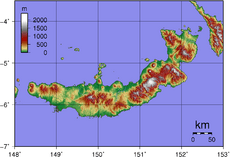
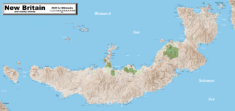
New Britain is shaped like a crescent moon. It is about 520 kilometers (323 miles) long along its southeastern coast. The island's width varies from 29 to 146 kilometers (18 to 91 miles). It is the 38th largest island in the world, covering an area of about 35,140 square kilometers (13,568 square miles).
Some parts of the coastline have steep cliffs. In other areas, the mountains are further inland, and the coast is flat with coral reefs. The highest point on the island is Mount Ulawun. This volcano is 2,334 meters (7,657 feet) tall. Most of New Britain is covered in tropical rainforest. Many large rivers flow through the island because it gets a lot of rain.
The Nakanai Range in East New Britain is made mostly of limestone. This limestone forms karst landscapes, which means it has unique rock formations. The erosion of this porous limestone has created large sinkholes and huge cave systems. The Nakanai Caves are so special that they were suggested as a World Heritage Site in 2007.
Provinces of New Britain
New Britain is part of the Islands Region of Papua New Guinea. The island is divided into two provinces:
- East New Britain: Its capital is Kokopo. It used to be Rabaul.
- West New Britain: Its capital is Kimbe.
A Look at New Britain's History
Scientists have found signs that people have lived on New Britain for thousands of years. Evidence from near Yombon shows human life dating back to 21,000 BC.
Modern History of the Island
Early European Visits
The first European to visit New Britain was William Dampier. He was a British explorer who arrived on February 27, 1700. He named the island Nova Britannia, which means "New Britain".
During the 1800s, whaling ships from Britain, Australia, and America often stopped at the island. They came to get food, water, and wood.
German Rule
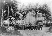
In November 1884, Germany took control of the New Britain area. The German government renamed New Britain as Neupommern ("New Pomerania"). They also renamed New Ireland as Neumecklenburg. The entire group of islands became known as the Bismarck Archipelago. New Britain was then part of German New Guinea.
By 1909, about 190,000 native people lived on the island. There were also about 773 foreigners, mostly Europeans. Most of these foreigners lived in the northeastern Gazelle Peninsula, where the capital, Herbertshöhe (now Kokopo), was located. At that time, large farms grew crops like copra, cotton, coffee, and rubber. Europeans did not explore the island's interior much at first. They thought the native people were warlike and would fight against outsiders.
World War I
New Britain was the site of one of the first battles of World War I. On September 11, 1914, Australian soldiers landed on the island. They quickly defeated the German forces and took control of the island for the rest of the war.
Between the World Wars
After World War I, the Treaty of Versailles was signed in 1919. Germany lost all its lands outside Europe. In 1920, the League of Nations put New Britain and the former German colony on New Guinea under Australia's control. This area was called the Territory of New Guinea.
World War II
During World War II, the Japanese attacked New Britain soon after the war started in the Pacific. A small Australian group called Lark Force defended important bases at Rabaul and Kavieng on New Ireland. In January 1942, the Japanese heavily bombed Rabaul. On January 23, thousands of Japanese marines landed, starting the Battle of Rabaul.
Many civilians were evacuated from New Britain in March 1942. However, others were captured in Rabaul when it fell. The Japanese used Rabaul as a key base until 1944. It was a central point for their failed attempt to invade Port Moresby on New Guinea.
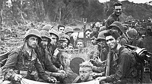
Later, the U.S. 1st Marine Division invaded New Britain. They landed in the Cape Gloucester area at the very western end of the island. Other U.S. Army soldiers landed at different coastal spots. The conditions at Cape Gloucester, with its swamps and mosquitoes, were very tough for the Marines. They captured an airfield but did not fully defeat the Japanese base at Rabaul.
The Allied plan was to avoid a direct attack on Rabaul. Instead, they surrounded it with air and naval bases on nearby islands and on New Britain itself. The nearby island of New Ireland was completely bypassed.
After 1945
In 1994, the main town of Rabaul had to be evacuated. This was because of a volcanic eruption that buried the town under a thick layer of ash.
People and Culture of New Britain
The native people of New Britain belong to two main groups. The Papuans have lived on the island for tens of thousands of years. The Austronesians arrived about three thousand years ago.
People on New Britain speak about ten Papuan languages and around forty Austronesian languages. They also speak Tok Pisin and English. Most of the Papuan people live in the eastern part of the island. Some also live in small areas in the central mountains.
In 2010, the population of New Britain was 493,585. Most people on the island are Austronesian. The largest towns are Rabaul/Kokopo in East New Britain and Kimbe in West New Britain.
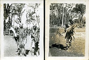
New Britain has many different and interesting traditional cultures. For example, the Tolai people from the Rabaul area have a matrilineal society. This means that family lines and property are passed down through the mother's side. Other groups follow a patrilineal system, where things are passed down through the father's side. Many traditions are still active today, such as the dukduk secret society in the Tolai area.
Languages Spoken on New Britain
Many different languages are spoken on New Britain. They can be divided into two main groups:
- Non-Austronesian (or Papuan) languages:
- Taulil and Butam (Butam is now extinct)
- Sulka
- Baining languages: Mali, Kaket, Kairak, Simbali, Ura
- Kol
- Makolkol
- Anêm
- Ata
The last two languages listed above are spoken in West New Britain. The others are mostly spoken in East New Britain.
- Austronesian languages:
- Tolai
- Lungalunga
- Siasi
- Kimbe
- Lamogai
- Mengen
- And other North New Guinea languages.
New Britain's Ecology and Environment
The island is part of two main ecoregions, which are areas with distinct types of plants and animals. The New Britain–New Ireland lowland rain forests cover areas from sea level up to 1,000 meters (3,280 feet) high. The New Britain–New Ireland montane rain forests cover the mountains of New Britain above 1,000 meters (3,280 feet).
Sadly, the forests on New Britain have been disappearing quickly in recent years. This is mostly because land is being cleared to grow oil palm trees. Lowland rainforests have been hit the hardest. Almost a quarter of the forest below 100 meters (328 feet) was lost between 1989 and 2000. If this rate of deforestation continues, it's thought that all forests below 200 meters (656 feet) could be gone by 2060.
Even with this loss, most forest birds on New Britain are still common. However, some birds that depend on the forest, like the New Britain kingfisher, could be at risk of extinction if the forests keep disappearing.
See also
 In Spanish: Nueva Bretaña para niños
 | Bayard Rustin |
 | Jeannette Carter |
 | Jeremiah A. Brown |


