
Pomerania facts for kids
Quick facts for kids
Pomerania
Pomorze, Pommern, Pòmòrskô
|
||
|---|---|---|
|
||
 |
||
| Countries | ||
| Largest city | Szczecin | |
| Demonym(s) | Pomeranian | |
| Time zone | UTC+1 (CET) | |
| • Summer (DST) | UTC+2 (CEST) | |


Pomerania (in Polish: Pomorze; in German: Pommern; in Kashubian: Pòmòrskô) is a historical region in Central Europe. It is located on the southern coast of the Baltic Sea. Today, Pomerania is split between Germany and Poland.
The name "Pomerania" comes from a Slavic phrase, po morze. This means "by the sea" or "on the sea". The region stretches from the Recknitz and Trebel rivers in the west to the Vistula river in the east.
Pomerania has several large islands, including Rügen, Usedom, and Wolin. The biggest city in Pomerania is Gdańsk. However, if you use a narrower definition of the region, then Szczecin is the largest city. Outside of its cities, Pomerania is mostly farmland. It also has many lakes, forests, and small towns. After World War II, many people who lived there before the war moved away or were asked to leave.
Contents
Exploring Pomerania's Geography

Where Pomerania is Located
Pomerania is the area along the Bay of Pomerania, which is part of the Baltic Sea. It lies between the Recknitz and Trebel rivers in the west and the Vistula river in the east. In the past, it might have reached as far south as the Noteć river. But since the 1200s, its southern border has been further north.
Pomerania's Landscape and Features
Most of Pomerania is flat coastal land. It is part of the large North European Plain. However, its southern parts are hilly. These hills are part of the Baltic Ridge. This ridge is made of piles of rock and dirt left behind by glaciers during the Ice Age. Inside this ridge, you can find many lakes formed by these glaciers. This area is called the Pomeranian Lake District. The soil in Pomerania is generally not very rich. It can sometimes be sandy or marshy.
The western coastline of Pomerania is very uneven. It has many peninsulas, like Darß–Zingst. There are also islands such as Rügen, Usedom, and Wolin. These islands and peninsulas create many bays and lagoons. The biggest lagoon is the Szczecin Lagoon.
The eastern coastline is much smoother. Lakes like Łebsko used to be bays but are now cut off from the sea. The easternmost coast, near the Gdańsk Bay, has the Hel Peninsula and the Vistula peninsula. These long strips of land stick out into the Baltic Sea.
Ancient Times and Early Tribes
About 20,000 years ago, the land that is now Pomerania was covered in ice. This ice began to melt and move north around 10,000 BC. This was during the late Paleolithic or Old Stone Age. Over time, different ancient cultures developed here. These included cultures from the Mesolithic (Middle Stone Age), Neolithic (New Stone Age), Bronze Age, and Iron Age.
From about 500 BC to 500 AD, Germanic tribes lived in Pomerania. These included groups like the Goths. Evidence from archaeology and their own stories suggest they came from Scandinavia. Roman historians wrote about Goths and Rugians in Pomerania around 98 AD. Another group, the Veneti, who were not Germanic, lived near the Vistula river. They later mixed with the Slavs. By the 600s, Slavic tribes, also known as Wends, settled in the area. One of these tribes was called the Pomeranians.
Pomerania's Place in History: Poland, Denmark, and Germany
Pomerania was first taken over by the Polish duke Mieszko I in the late 900s. But there were uprisings by pagan groups in 1005 and 1038. These led to parts of Pomerania becoming independent again. Poland regained control in 1116/1121. However, the Polish rulers could not hold onto the Duchy of Pomerania for long. By 1135, it was no longer under Polish control. Another part, Pomerelia, became part of Poland in 1138. But it was later declared a part of the Holy Roman Empire in 1156.
The western part, known as the Duchy of Pomerania, became part of the Holy Roman Empire in 1181. It was briefly ruled by Denmark from 1168/1186 to 1227. After that, it remained part of the Holy Roman Empire until 1806.
Major Cities and Towns in Pomerania
Here are some of the larger cities in the historical region of Pomerania, with their populations from 2012:
- Szczecin (West Pomeranian Voivodeship, 408,913 people; its wider metropolitan area has up to 763,321 people).
- Stralsund and Greifswald form a high-level urban center in Mecklenburg-Vorpommern (total population 113,128).
- Stralsund (57,357 people)
- Greifswald (55,771 people)
- Koszalin (West Pomeranian Voivodeship, 109,343 people)
- Słupsk (Pomeranian Voivodeship, 94,849 people)
- Stargard (West Pomeranian Voivodeship, 69,724 people)
.jpg)
,_by_Klugschnacker_in_Wikipedia_(7).JPG)
Other important cities in the Pomeranian and Kuyavian-Pomeranian regions include:
- Tricity metropolitan area (Pomeranian Voivodeship) (population in 2012: over 1,035,000 people). This area includes:
- Toruń (Kuyavian-Pomeranian Voivodeship, 205,934 people)
- Grudziądz (Kuyavian-Pomeranian Voivodeship, 96,042 people)
- Tczew (Pomeranian Voivodeship, 60,279 people)
.jpg)
Images for kids
-
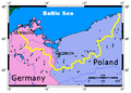
A map showing Pomerania.
-
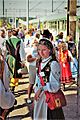
Kashubians wearing traditional clothes.
-
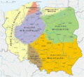
A map of Polish dialects. The Pomerania region includes the Kashubian language and a mix of Polish dialects.
-
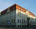
The National Museum in Szczecin.
-
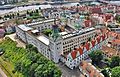
A view of Szczecin.
-
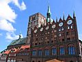
Stralsund, a city built in the typical Brick Gothic style, like many Hanseatic cities.
-
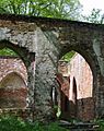
The ruins of an Augustinians' monastery in Jasienica, Police.
-
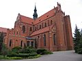
The Cathedral Basilica of the Assumption in Pelplin, one of Poland's largest churches.
-
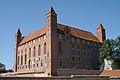
The Teutonic Knights' castle in Gniew, Pomerelia.
-
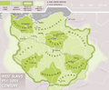
A map showing West Slavic tribes in the 9th-10th centuries.
-
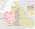
A map showing how Poland's borders have changed over time.


.jpg)


.jpg)


See also
 In Spanish: Pomerania para niños
