Kavieng facts for kids
Quick facts for kids
Kavieng
Bilas Peles
|
|
|---|---|
| Kavieng | |

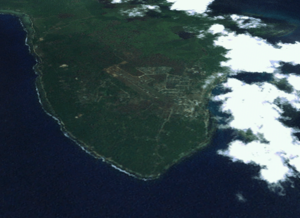
Satellite image of the Kavieng peninsula
|
|
| Country | Papua New Guinea |
| Province | New Ireland |
| District | Kavieng District |
| LLG | Kavieng Urban |
| Founded | 1900 |
| Elevation | 10 m (30 ft) |
| Population
(2012)
|
|
| • Total | 19,849 |
| • Rank | 14th |
| Languages | |
| • Main languages | Tok Pisin, English, New Ireland languages |
| • Traditional language | Tigak, and some Tiang from Dyaul Island |
| Time zone | UTC+10 (AEST) |
| Mean max temp | 30.2 °C (86.4 °F) |
| Mean min temp | 22.5 °C (72.5 °F) |
| Annual rainfall | 3,183 mm (125.3 in) |
| Climate | Af |
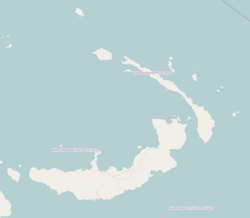
Kavieng is the capital city of the Papua New Guinean province called New Ireland. It is the biggest town on the island of New Ireland. You can find Kavieng at Balgai Bay, right at the northern tip of the island. In 2009, about 17,248 people lived there.
Kavieng is a very important port for the New Ireland province. It is a busy place for both trade and tourism. Many companies offer diving trips from the town. This area is famous for its amazing diving spots. You can explore natural reefs and even shipwrecks from the Second World War. Some plane and shipwrecks are right in Kavieng Harbor. More can be found very close by.
The town has its own airport, Kavieng Airport. You can fly from Kavieng to Port Moresby every day. Kavieng is also at one end of the Boluminski Highway. This paved road stretches for 293 kilometers (about 182 miles) all the way to Namatanai.
Kavieng offers many services, just like any local administrative center. You can find government offices and places to shop. There are also hotels like the Kavieng Hotel and the Malagan Beach Resort. The Kavieng Club used to be a "colonial club." The town has a hospital that provides general medical care, services for children, and surgery. There is also a weekly market where you can buy fresh goods. A large wharf on the edge of town is used for exporting copra (dried coconut meat). Big ships can load copra and oil directly from the land here.
From Kavieng, you can see many islands that are part of an archipelago. These islands are located between New Ireland and New Hanover. Some of these islands include Nusa Lik, Nusa Lawa, and Nango Island. Nango Island used to have a fish cannery in the 1960s and 1970s. Today, Nango is home to a new marine research center. This center is for the PNG National Fisheries Authority. The Governor-General of PNG, Mr. Paulius Matane, opened it in July 2009.
Contents
Discovering Kavieng's Past
The area around Kavieng was first explored by Dutch sailors in 1616. However, the town of Kavieng itself was not started until the early 1900s. It was founded by the German colonial government. Some people on the island became very rich by growing copra. But Kavieng remained a small settlement. It had only about eighty residents back then.
After the First World War, Kavieng became part of Papua New Guinea. It was then controlled by Australia. This change meant that German missionaries had to leave. All German property in the town was taken over.
Kavieng During World War II
On January 21, 1942, during World War II, Japanese forces heavily bombed Kavieng. That night, most Australians left New Ireland. The Japanese army then invaded and took over the island on January 24. For the next two years, almost all the Europeans who had stayed on the island were killed by the Japanese.
Rear Admiral Ryukichi Tamura gave an order. He said that all European prisoners in Kavieng should be killed if Allied forces were about to invade. At least twenty-three of these prisoners were killed in the Kavieng Wharf Massacre in March 1944. Later, the people responsible for these killings were found guilty of war crimes. By the time the Allies took back the island in 1945, Kavieng was almost completely destroyed.
Exploring War Relics Today
Because of the Japanese occupation and the Allied invasion, you can still find many wartime items in Kavieng. One notable relic is a large gun sitting above a bunker. It is right next to Harbour Road. This bunker is not officially open to the public. However, it has several openings that allow you to go inside. From the gun's position, you get a great view of the harbor.
Today, Kavieng has a growing tourism industry. People come for diving, trekking, and surfing. All this tourism depends on the rich variety of plants and animals in New Ireland. The surf tourism industry works with local land and reef owners. Together, they have created a "surf management plan." This plan helps local owners earn money from surfers. It also limits how many surfers can be at one spot at a time.
Kavieng's Tropical Weather
Kavieng has a tropical rainforest climate (Af). This means it has hot days and warm nights all year round. It also gets a lot of rain throughout the year.
| Climate data for Kavieng (1975–2007) | |||||||||||||
|---|---|---|---|---|---|---|---|---|---|---|---|---|---|
| Month | Jan | Feb | Mar | Apr | May | Jun | Jul | Aug | Sep | Oct | Nov | Dec | Year |
| Mean daily maximum °C (°F) | 30.7 (87.3) |
30.6 (87.1) |
30.8 (87.4) |
30.8 (87.4) |
30.8 (87.4) |
30.6 (87.1) |
30.4 (86.7) |
30.5 (86.9) |
31.0 (87.8) |
31.1 (88.0) |
31.1 (88.0) |
30.7 (87.3) |
30.8 (87.4) |
| Mean daily minimum °C (°F) | 24.0 (75.2) |
23.9 (75.0) |
24.1 (75.4) |
23.8 (74.8) |
23.7 (74.7) |
23.4 (74.1) |
22.9 (73.2) |
23.1 (73.6) |
23.1 (73.6) |
23.4 (74.1) |
23.5 (74.3) |
23.8 (74.8) |
23.6 (74.4) |
| Average rainfall mm (inches) | 312.6 (12.31) |
294.6 (11.60) |
325.8 (12.83) |
280.0 (11.02) |
253.0 (9.96) |
209.4 (8.24) |
246.6 (9.71) |
202.0 (7.95) |
171.6 (6.76) |
213.9 (8.42) |
210.2 (8.28) |
265.0 (10.43) |
2,984.7 (117.51) |
| Average rainy days | 23 | 21 | 23 | 21 | 21 | 21 | 22 | 19 | 17 | 19 | 19 | 22 | 248 |
| Source: World Meteorological Organization | |||||||||||||
See also
 In Spanish: Kavieng para niños
 | Bessie Coleman |
 | Spann Watson |
 | Jill E. Brown |
 | Sherman W. White |


